People are drawn to oceans coasts as places to live, work, and play. But coastal environments are continuously evolving on both short and long-time scales. Coasts are very sensitive and responsive to changes in climate and ocean conditions. When people establish permanent infrastructure in this unstable environment natural processes quickly become hazardous.
Chronic Hazards
Chronic hazards are those hazards that constantly affect the coast: beach, dune, and bluff erosion; slides, slumps, and gradual weathering of sea cliffs; and flooding of low-lying areas during major storms. Some areas may experience considerable sand buildup as well. Chronic hazards come from winter storms, associated storm surges, and wave setup; strong nearshore currents; high winds, rain, runoff, and associated lowland flooding; and elevated sea levels caused by seasonal effects, periodic El Niños, and rising sea levels.
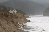
Waves, currents, tides, and storms are constantly affecting beaches and headlands, causing erosion, landslides, and flooding. Many coastal features such as beaches and sand spits are constantly changing. Attempts to stabilize such features so they cannot change in most cases are futile, because the forces that have shaped this land for millions of years are not easily overruled. For example, cliffs with marvelous views are there because land in front of them has slid away. And areas that have had one landslide are likely to have others. The coast of Oregon is constantly under attack by the ocean.
Coastal Flooding
Floods occur when water levels become so high that they exceed and submerge the surrounding land. They are typically associated with storms, which often bring large waves, low atmospheric pressure, rainfall and high winds, which push the water onshore. Also influencing the magnitude of a flooding event is the tides-- as they govern the landward extend of the water levels.
Most open-ocean coastal flooding occurs on low-lying areas such as small dunes, river inlets, and sand spits where the water levels can easily surpass (or overtop) the land. Also commonly affected by flooding events are coastal estuaries. Large amounts of rainfall and higher than normal tides frequently inundate low-lying estuaries behind the dunes.
Beach/Dune Erosion
Beaches and sand dunes are some of the most responsive landforms to environmental forces. Because they are composed of a buildup of individual sand grains, which are constantly being shifted by wind, waves and currents. However, for major erosion to occur involves a combination of unusually intense waves, strong nearshore currents that remove sand from the beach, and high water levels due to tides, storm surge and wave setup. Over the past century, the Oregon coast has undergone several periods of major coastal erosion in which the mean shoreline position retreated landward, encroaching on homes built atop dunes. It is estimated that the winter of 1939 was the worst on record as it resulted in extensive coast-wide erosion and the breaching of several low lying "sand spits".In particular, El Niñowinters tend to be responsible for increased elevated erosion of beaches and dunes, and migration of river inlets. Evidence of the impact these climate-driven events have on beaches was most recently seen during the winters of 1982/1983, 1997/1998, and most recently in 2015/2016.
Beaches and dunes are the first line of defense against harsh ocean conditions. They dissipate the energy of powerful ocean waves thereby preserving the land located behind these features. Because many of these areas in Oregon have been partitioned for development of homes/businesses and set aside for wilderness preservation and parks, erosion of fronting beaches and dunes will cause exposure of these communities and ecosystems. The bottom line is that loss of a beach is the loss of a habitat--for both humans and other organisms dependent on these environments.
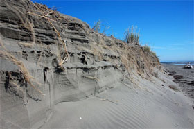
Bluff Erosion/Landslides
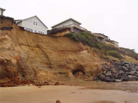
Although sandy beaches and dunes often exhibit changes such as erosion at a rapid rate, it is the long-term retreat of coastal bluffs that is responsible for the largest loss of property values. Much of the coastal infrastructure along Oregon's shore is developed on marine terraces, which have been formed on the ocean floor by a layering of mudstone and siltstones. Tectonic uplift has exposed these rocks to the weather and waves, which continue to cut away at these landforms. Additionally, these originally horizontally stratified layers have undergone deformation during the accretion process and now dip seaward, promoting landslides.
The erosion of bluffs is dependent on multiple factors including: ocean wave impact, variations in ground water levels, vegetation cover, bluff slope and bluff material properties. When coupled with the varied geologic composition of the Oregon coastline, this wide range of eroding mechanisms makes the task of estimating how fast the bluffs are eroding very complicated with large amount of uncertainty. Thus, there is no "one-size-fits-all" approach that can be applied coast wide and assessments are typically made on a case by case basis.
Catastrophic Hazards
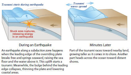
Catastrophic hazards are associated with earthquakes and related tsunamis. The eastward-moving Juan de Fuca tectonic plate dives under the westward-moving North American plate just off the Oregon coast at the Cascadia Subduction Zone. Powerful earthquakes up to magnitude 7 can take place in either the North American or the Juan de Fuca plates. The Cascadia Subduction Zone, however, is capable of generating even larger earthquakes — up to magnitude 9.
Tsunamis
Atsunamiis a series of ocean waves most often generated by disturbances of the sea floor during shallow, undersea earthquakes. Less commonly, landslides and volcanic eruptions can also trigger these wave events. Although infrequent in occurrence, tsunamis are the most dangerous natural hazard affecting the Oregon Coast. In the deep water of the open ocean, tsunami waves can travel at speeds up to 800 km (500 miles) per hour and are imperceptible to ships because the wave height is typically less than a few feet.
However, as a tsunami approaches the coast it slows dramatically and its height may multiply by a factor of 10 or more, having catastrophic consequences to people living at the coast. As a result, people on the beach, in low-lying areas of the coast, and near estuary mouths or tidal flats face the greatest danger from tsunamis.
The Oregon coast is a part of the tectonically active
Pacific Ring of Fire, posing the risk for both locally and distantly generated tsunamis. The close proximity of the Cascadia Subduction Zone, a 960-km-long (600 mile) earthquake fault zone that sits off the Pacific Northwest coast has the potential to generate earthquakes of magnitude 9.0 or greater. Following the earthquake will be a destructive tsunami, which will reach the coast in 10-20 minutes making the local event the most dangerous type of tsunami for Oregon.
A distant tsunami produced by an earthquake far from Oregon will take 4 or more hours to travel cross the Pacific Ocean, usually allowing time for an official warning and evacuation, if necessary. A distant tsunami will be smaller in size and much less destructive, but it can still be very dangerous.