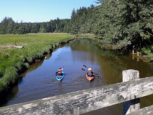
 At South Slough Reserve, freshwater streams flow through forests into the estuary, creating waterways teeming with life. Visitors who explore the Reserve via kayak or canoe can experience the rich cultural and natural history of the area, while viewing a diversity of wildlife, on a trail that flows with the tide. By boat, you may see local and migratory birds, playful seals in the distance, jumping shiner perch, jellyfish floating through the channel, and crabs crawling along the estuary bottoms.
Visitors may paddle the Reserve on their own or join a guided tour. You can bring your own kayak or canoe to the Reserve or rent one for a guided tour. All boats over 10 feet must have an invasive species permit.
Motorized boating is permitted, except in special protection zones. Boating must occur at a reduced speed and waves created by the wake must be less than one foot high, to prevent disturbance to the tidelands and wildlife habitat.
Guided Tours
Guided tours are offered several times a year, during which a naturalist guide leads groups along a water route. Shuttles are provided to transport participants to the end of the five-mile trip. A limited number of kayaks are available to rent during tours for $45, which covers the kayak, paddle, a life vest, and the guided paddle trip.
Visit the
community classes calendar to see scheduled upcoming trips and registration information.
Planning Your Paddle Trip
Cell service may be nonexistent in the South Slough, so plan accordingly. Tides are the most important factor in determining the timing of a paddle trip because an outgoing tide can leave you stuck on a mudflat or sandbar.
For more information, review the Guide to Paddling the South Slough PDF.
Water Trails
You can launch from the public dock or the tide flats at the Port of Coos Bay Distant Water Fleet Facility, located on Troller Lane in Charleston. If you launch from here, you will have to walk across an expanse of mud to reach the water during low tides.
This water trail runs along former 1900's logging camps that were situated in the surrounding hills. The four to five mile trip offers views of kingfishers, Great Blue Herons, and expansive eelgrass beds that provide hiding places for many small fish. Plan your trip through the upper portions of Winchester Creek when the tide is high, as when the tide is low there may be only a small section of water flowing through this portion (note that the tide tables for Charleston are one hour ahead of time for this area). From here it is a short distance to the north where Winchester arm widens. When returning under the Hinch bridge, you can continue south for about a mile until the channel becomes too narrow to navigate, then turn around. Or finish your trip here and use the paddle launch to exit.
Named after a family that operated a large cattle ranch in the Elliot Creek area, this trail offers opportunities to spot wildlife, like herons wading along the shallow, muddy bottoms looking for food. To access this trail, launch your boat at the Port of Coos Bay Distant Water Fleet Facility in Charleston. Continue south for about two miles until your reach Long Island Point. Sengstaken is east. There is no take-out point at the end, the waterway will just become narrower and shallower. Turn around and return to start once you reach this point.
This one way trip takes you through much of the Reserve, including past Valino Island, the northern boundary of the Reserve and a former lily farm, saloon, and hideout area. To access this trail, we recommend parking one vehicle at the bottom of Hinch Road and another at the Port of Coos Bay Distant Water Fleet Facility in Charleston, where you will launch. Once in the water, travel southwest across the channel towards Collver Point. From there aim south, staying in the channel. About two miles into the trip, you will see Valino Island on the left. The sand bars surrounding the island require those journeying south to navigate a wide path through the channel over to the long island point junction between the Sengstaken and Winchester Arm of the Slough. Here is a good place to take a break and get out of the boat to stretch your legs. Take the Winchester arm staying in the middle of the channel as you head south. You will eventually pass the Sloughside pilings and dredge spoil islands, where there are a series of boxes that shelter purple martin nests stationed along the pilings. Next, you will meander through the marshes, several of which have been restored from former tide-gated farmlands. When you reach the end of Winchester Creek, the channel narrows, watch for pilings and sandbars. Paddle under the bridge and exit at the Hinch Bridge launch.