What is a "regulatory mixing zone"?
A mixing zone is an area where wastewater discharged from a permitted facility enters and mixes with a stream or water body. A mixing zone is an established area where water quality standards may be exceeded as long as acutely toxic conditions are prevented and all beneficial uses, such as drinking water, fish habitat, recreation, and other uses are protected.
DEQ calculates mixing zones to be as small as feasible. The size of the area or zone varies based on how concentrated the wastewater discharge is, water quality standards, location of the discharge in relation to critical habitat or drinking water intakes, and size or flow of the waterbody. Not all permitted facilities have mixing zones. Most mixing zones in Oregon vary in size from 5 to 300 feet from the point of discharge.
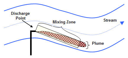
Figure 1: Example of a Typical Mixing Zone
Mixing zones are designed to be protective
DEQ does not permit mixing zones in locations where there is long-term (chronic) human exposure, such as wading beaches or drinking water intakes. Furthermore, DEQs water quality rules do not allow for the discharge of toxic pollutants in concentrations that would be dangerous for people and wildlife if they swim or float through a mixing zone. Figure 2 is an example of the type of modeling DEQ uses to evaluate the mixing zones and more information can be found at the CORMIX Mixing Zone Model home page.
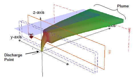
Figure 2: Example of Water Quality Modeling
Mixing zones are just one part of the process DEQ uses to protect water quality
The calculation and alignment of a mixing zone is an important component of the overall permitting process that includes the following processes:
- Review of the ambient water quality of the receiving water body
- In-depth inspection and review of facilities requesting permits or renewals
- Ongoing monitoring of all facility effluent
- Effluent sampling and characterization
- Evaluation of the receiving water body to prevent any degradation of water quality
- Development of water effluent limits to ensure the protection of public health and the environment
Are mixing zones legal?
Yes. Under federal rules, the use of mixing zones is approved in most states, including Oregon. Mixing zones are required to protect the beneficial uses of water such as drinking water, fish habitat, recreation, and irrigation.
How are mixing zones regulated?
The federal Environmental Protection Agency allows states to adopt their own mixing zone regulations as part of the states water quality standards (40 CFR 131.13). These state regulations are subject to review and approval by EPA. Oregon's mixing zone rule has been approved by EPA and can be found at Oregon Administrative Rule 340-041-0053.
In addition, there is both federal and state guidance on when mixing zones may be allowed. EPA provides guidance on mixing zones in Water Quality Standards Handbook, August 1994 and Technical Support Document for Water Quality-based Toxics Control, March 1991 PDF (6.5MB). DEQ has recently developed guidance documents to assist permit writers to properly size and locate the zones so that they are more protective of the environment and public health.
Who is subject to mixing zone regulations?
The mixing zone regulations currently affect about 300 facilities (including both municipal wastewater treatment plants and industries) that operate under existing water quality permits. DEQ will review and, if necessary, update each mixing zone every five-years during the facilities permit renewal cycle. Any permit applicants requesting a mixing zone would also need to conform to the mixing zone regulations.
Where are mixing zones located?
Information about specific mixing zones is available by:
- Contact your regional DEQ office and ask for the Water Quality Program. The staff will help in accessing public records which describe permitted facilities and the location of their associated mixing zones.
- Access DEQs Wastewater Permits Database. The database can be queried based upon county, city, zip code or watershed name, and will report location by address and geographic coordinates.
- DEQ has developed maps of the location of major sewage treatment plants and industrial facilities with mixing zones on the Willamette River. The maps show the approximate river mile location of the facilities and contain information from the permit and related documents:
How do I get information on regulatory mixing zones in my area?
For more detailed on a particular permit or mixing zone, contact the nearest DEQ office to schedule an appointment to look at permit files. The files will include specific information about the mixing zone, including its size and location. There is also a public comment and review process associated with each new permit and permit renewal.