Overview
OWRD is taking steps to reduce groundwater level declines within the Harney Basin. The Department will post all information about activities on this page as it becomes available.
OWRD Activities in Harney Basin
All dates are estimates and are subject to change. This process involves OWRD and the Office of Administrative Hearings.
Click on the timeline to see Department actions and date estimates.
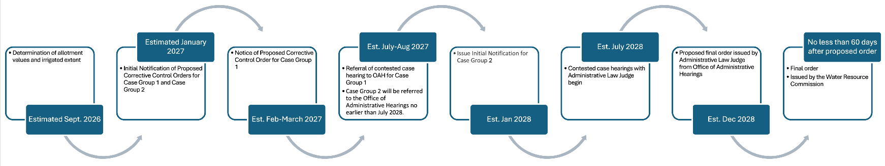
OWRD anticipates referring two groups of subareas to OAH for contested case. The first group will include the Northeast Crane, Weaver Springs, and Dog Mountain subareas. The second group will include the Silvies, Silver Creek, and Lower Blitzen subareas. The second group of subareas will be referred to OAH once the hearing for the first group is completed.
You can find information about allotment and the contested case process here.
Serious Water Management Problem Area
For more information about requirements within the Serious Water Management Problem Area, please visit the Harney Basin SWMPA Page.
Critical Groundwater Area
More information coming soon. Please visit the
Division 512 Rules for more information on the CGWA.
Place-Based Planning
A product of
OWRD’s Integrated Water Resources Strategy, the Harney Community-Based Water Planning (CBWP) Collaborative is undertaking a
place-based approach to water resources planning. This group of farmers, ranchers, business-people, government officials, tribal members, landowners, conservationists and other interests have been working together to gather information, identify strategies, and determine in-stream and out-of-stream water resources needs to help develop solutions that will meet those needs now and into the future.
For more general information, click this link:
https://harneyswaterfuture.com/.
Other