This page provides information on how to use the Klamath Basin Status Page and the Klamath Tribal Instream Claim Dashboard. More information is listed below.
IMPORTANT UPDATE ON KLAMATH BASIN WATER REGULATION AND ENFORCEMENT
Some water users in the Upper Klamath Basin will be affected by a change in regulation. The Oregon Water Resource Department (OWRD) is updating its instream flow requirements for some determined claims that incorporate a condition triggered by the return of anadromous fish to the Upper Klamath Basin. We want to ensure you have the information you need to understand these changes and how they might affect your water use.
Why is this change happening?
The recent removal of the Klamath River dams cleared the way for fish, such as Fall Chinook, to return to the Upper Basin. Because of this, OWRD is required to implement regulation for "Conditional Physical Habitat Flows." This means the instream water claims designed to support these fish habitats will now be actively regulated and enforced.
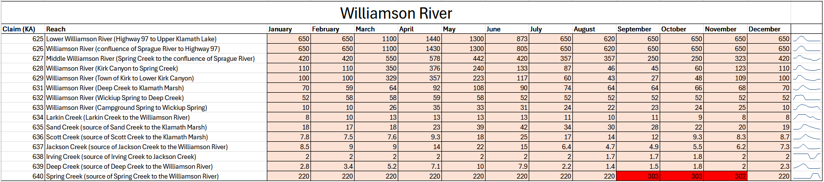
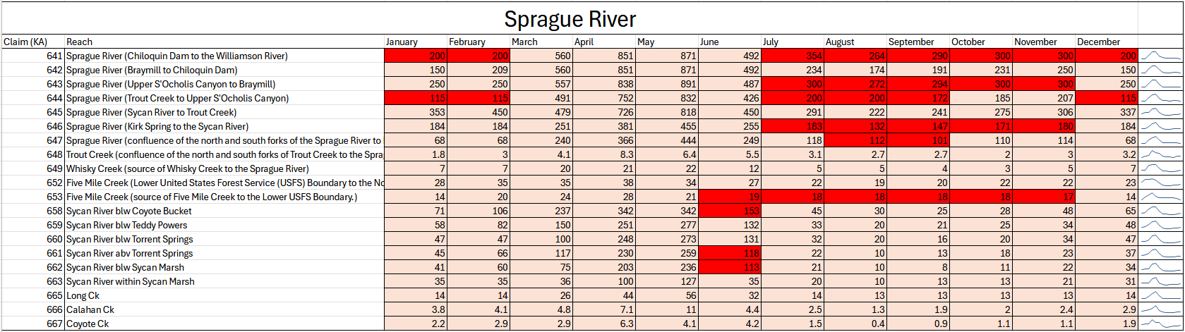
There are 38 tribal determined instream claims in the Upper Klamath Basin. The instream flow requirements increased in 10 of the 38 reaches, during certain months of the year.
Will this impact your access to water?
We anticipate that most water users will not experience a substantial change in regulation from previous years. The new conditional instream flow values apply to approximately one quarter of the Upper Basin’s tribal claims. And typically, the affected reaches are regulated by a senior call for water on the lower Williamson.
However, depending on location and the priority date of a water right, this change could potentially limit some water users’ access to water during some months of the year. We recommend that all water users monitor their status, closely.
What reaches and in what months will determined claims be affected?
Refer to the tables below for a detailed breakdown of reach‑specific and month‑specific changes to the regulation of tribal instream determined claims. The salmon‑colored boxes represent existing instream claim flow values that will remain unchanged. The red‑colored boxes identify months and reaches where flow numbers have been modified due to the implementation of the conditional physical habitat flows.
For additional clarification or questions about how these changes may affect regulation within your area, please contact the Klamath Falls Watermaster’s Office.

Klamath Basin Status Page
The Klamath Basin Status Page lists the current regulation status for river and tributary reaches in the Klamath Basin. This page is designed to inform water users when their appropriated right to pump or divert water from their source (source is specified in permit, certificate or determined claim) is under regulation or is available for use. It's updated by the Watermaster when changes are made to the regulation of appropriated water in the Basin, often the result of a senior call for water. Water users are encouraged to check this site regularly.
How to use the Klamath Basin Status page:
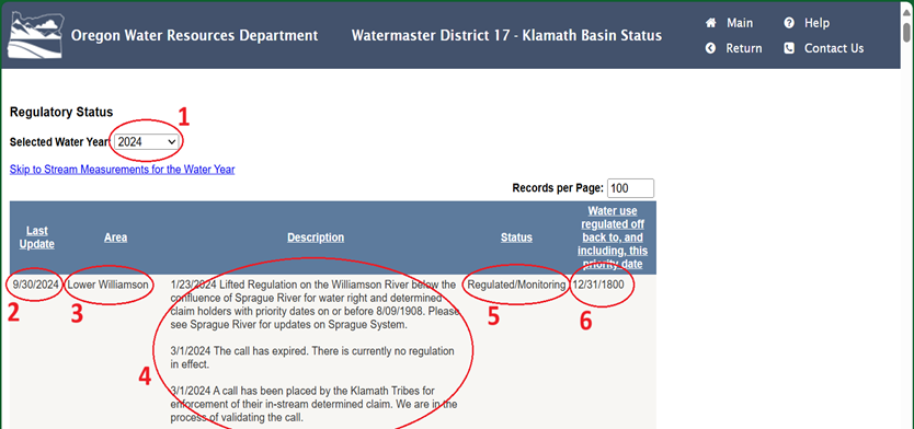
On this webpage (see above graphic):
(1) current water year is selected by default; previous water year data can also be accessed. The dashboard contains five columns, to include the (2) date of the last update, (3) the area or designated water reach, (4) a description of the current regulation, (5) the status of the regulation, (6) and the date of priority for allowed use of natural waters for valid water rights.
Navigation tools allow the water user to scroll through the page to find their specific area, designated water reach (listed in the valid water right). Once the correct water reach is identified, the description column will contain a record of regulation notices issued by the Watermaster for that water reach during the designated water year; each entry is date stamped and the most current dated entry will be the regulation currently in effect.
Visit the Klamath Basin Status Page.
Direct link: https://apps.wrd.state.or.us/apps/misc/dsb_area_status/Default.aspx?wm_district=17
Klamath Tribal Instream Claim Dashboard
The Klamath Tribal Instream Claim Dashboard is an informational tool that Oregon Water Resources Department (OWRD) provides as a visual representation of current data that is used to help water users understand current conditions and water availability in the Klamath basin as it pertains to the adjudicated instream claims.
How to use the Klamath Tribal Instream Claim dashboard:
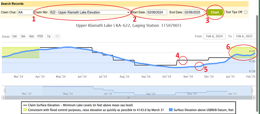
The webpage defaults to KA-622 – Upper Klamath Lake Elevation, which is the adjudicated instream tribal claim for Upper Klamath Lake (see above graph). The user can select from the (1) Claim Nbr dropdown, the designated and specific reach for their valid water right. The (2) date range can be adjusted to a designated time frame by the user. After designating the claim number and specific dates, the user can click on the (3) “Chart" button, which will update the graphic to the data from the specified water reach.
How to read the Klamath Tribal Instream Claim dashboard?
Reading the above graph: The webpage defaults to KA-622 – Upper Klamath Lake Elevation and is explained herein. The (4) black line represents the adjudicated tribal claim. The (5) blue line represents the current water level elevation of the designated reach. The (6) green box(es) represents ecological flows necessary for preserving environmental services, components, functions, processes, and the resilience of aquatic ecosystems.
Water use regulation is determined by the Watermaster, based upon current and forecasted conditions present in the Klamath Basin and the water user should always check the Klamath Basin Status page for specific details related to regulation of their designated water reach.
Visit the Klamath Tribal Instream Claim Dashboard.
Direct link: https://apps.wrd.state.or.us/apps/wr/klamath_sif_dashboard/Charts.aspx
Frequently Asked Questions
Where does the dashboard data come from?
Data is obtained from automatic monitoring equipment installed at strategic locations along streams and rivers of the Klamath Basin. Hydrological data includes flow, stage, and, at some locations, temperature of water in the designated reaches. OWRD field personnel perform on-site measurements of flow at these monitoring stations to validate automated data to ensure current regulations are true and correct.
What is a ‘priority date’ and where can I find mine?
i.
The priority date of a valid water right is typically the date the Department received the application for a permit to use water. Oregon's water laws are based on the principle of prior appropriation often referred to as “first in time, first in right." This means the first person to obtain a water right on a stream is the last to be shut off in times of low streamflow.
ii. The priority date of a valid water right will be noted in the certificate; i.e. “…that the priority of the right hereby confirmed dates from August 8, 1961”.
iii.
If you need information on water rights associated with your land, the
Water Rights Information System (WRIS) is a warehouse of information pertaining to water right applications, permits, certificates, transfers, leases and related information and can be accessed “here”.
How current is the hydrological data?
Data from monitoring sites is collected automatically by satellite telemetry and the timeframe varies depending on the site. Generally, data is collected daily but can range from every 15 minutes to once per day. Data collection is dependent upon the variable nature of the water course and weather conditions; water courses that fluctuate on a faster time scale in response to inflows (i.e. precipitation or melting) generally require data collection more frequently.
What does ‘prior appropriation’ mean?
Oregon's water laws are based on the principle of prior appropriation. Prior appropriation means the first person to obtain a water right on a stream is the last to be shut off in times of low stream flows. In water-short times, the water right holder with the oldest date of priority can demand the water specified in his or her water right without regard for the needs of junior users. If there is a surplus beyond what is necessary to fulfill the senior right, the water right holder with the next senior priority date can take what is available to satisfy needs under his or her right. This continues down the line until there is no surplus or until all rights are satisfied.
What is a ‘call’ for water?
In 1909, the Oregon Legislature adopted the Oregon Water Code, which established a system for the distribution of water use based upon the doctrine of prior appropriation. Under the doctrine of prior appropriation, when there is not sufficient water to meet all water rights, holders of senior water rights can make a “call" for water. The senior user is entitled to receive all of his or her water, before a junior user. For example, a senior user with a priority date of 1910 can make a call for water and users with a priority date that is junior to 1910) may be shut off to satisfy the senior right. OWRD is responsible for carrying out this management system on behalf of water right holders. For more information, please see 'Background Testimony for Senate Bill 206 and 264'.
Meaning of “Time Immemorial” Within the Klamath River Basin Adjudication
On March 7, 2013, the Oregon Water Resources Department (OWRD) transmitted its Final Order of Determination (FOD) for the Klamath River Basin Adjudication to the Klamath County Circuit Court. The FOD concludes an administrative process spanning nearly four decades and establishes the operative framework for regulating water rights in the Upper Klamath Basin unless and until the Circuit Court issues a final judgment following its review of any exceptions filed by participating parties. The document sets forth OWRD's determinations regarding the validity of various claims to the use or diversion of water within the Oregon portion of the Klamath Basin, including:
- water rights recognized under state law based on pre‑1909 appropriations (predating Oregon's water code), and
- federal reserved water rights.
Among the FOD's most consequential determinations are the following:
- the acknowledgment of extensive Klamath Tribal water rights with priority dates of “time immemorial" for instream flows in tributaries to Upper Klamath Lake and for maintaining water levels within the lake;
- the recognition of irrigation rights for consumptive use by landowners within the boundaries of the former Klamath Indian Reservation;
- the delineation of state‑based water rights for the Klamath Reclamation Project, including clarification of the respective interests of the United States, irrigation districts, and individual beneficial users; and
- the confirmation of federal reserved rights associated with national wildlife refuges and other federal lands.
With the filing of the FOD, the adjudication proceeds into its judicial phase, during which claimants and contesting parties may submit exceptions to the Circuit Court for review and resolution.
What are ‘ecological flows’?
“The importance of flowing water in the ecosystem was realized when the issues of dying rivers and the imminent threat to freshwater supply came to fore. Subsequently, there were efforts to understand the limit of maximum permissible withdrawal of water from a river so that its hydro-ecological functions are not drastically hampered. The term ecological flow means not only the quantity but also the quality of flowing water and also its cultural and aesthetic value. It identifies the required quantity, quality and distribution of flow patterns from the source to mouth of a river, preserving the life in and around the channels. The drastic reduction in flow in most of the river has the ecological cost. The already identifiable indicators of the ecological damage are longitudinal disconnectivity of the flowing channel, the falling level of the groundwater table and the loss of biodiversity. The greater common good of the human society does not lie in the abuse of the rivers; the future of civilization depends on fixing critical limits for the exploitation of water sources and allowing the rivers to flow."
Source: Rudra, K. (2018). The Concept of Ecological Flow. In: Rivers of the Ganga-Brahmaputra-Meghna Delta. Geography of the Physical Environment. Springer, Cham. https://doi.org/10.1007/978-3-319-76544-0_12
What are my water rights in Oregon?
OWRD has a publication explaining Oregon’s water laws and water rights. This Aquabook, titled “
Water Rights in Oregon: An Introduction to Oregon’s Water Laws”, includes information on current water law, water protections and restrictions, the application/transfer/cancelling of water rights, conservation, distribution and enforcement, and information pertaining to finding current water rights.
A printed copy of this publication is available at your local OWRD office.
What information is available for a water well?
OWRD has a publication titled “Water Well Owners Handbook: A guide to water wells in Oregon", with versions in English and Spanish, which explains general information about groundwater, water wells, well construction, protection of groundwater, water well operation and maintenance, safe drinking water supply, water well abandonment, and Oregon rules and statutes on water wells. This information is valuable if you own, wish to construct or plan to abandon a water well in Oregon. It may also be helpful to people renting, selling or buying property where wells are or will be located to meet water supply needs. This information may not apply to all situations and may change.
Where is my local OWRD office?
The Klamath Falls OWRD Watermaster's Office is located at:
3125 Crosby Ave, Klamath Falls, Oregon, 97603
Phone: 541-883-4182
Hours: Monday–Friday 8 a.m.–4:30 p.m.
The office is closed on federal holidays.