
Oregon State Flag An official website of the State of Oregon »

About the Study

We're Creating Safer, More Connected Routes

Aerial drone photo above OR 99W 

We’re working with Benton County to plan improvements that make it easier and safer for people walking, biking and rolling in north Corvallis and nearby communities.

As part of this effort, two new bike and pedestrian bridges are in development to improve key connections:

  • A bridge over Jackson-Frazier Creek near OR 99W, which will support the Corvallis to Adair Village Path. 
  • A bridge over OR 99W and the railroad, providing a critical link between the Cheldelin neighborhood and Good Samaritan Regional Medical Center.

These bridges and shared use paths will help reduce barriers, improve access to essential destinations and create safer crossings for people to travel car-free.


Click on the title or "+" below to expand the box to learn more.

This project is part of a larger vision to build a connected system of shared use paths linking neighborhoods, parks, schools and services throughout the region. 

It supports key goals in local and regional transportation and trail plans and is being developed through collaboration with Benton County, ODOT, Corvallis, Greenbelt Land Trust and others.

Community input will help guide the design process to ensure these routes ​work for people of all ages and abilities.

Owens Farm and Jackson-Frazier Wetland

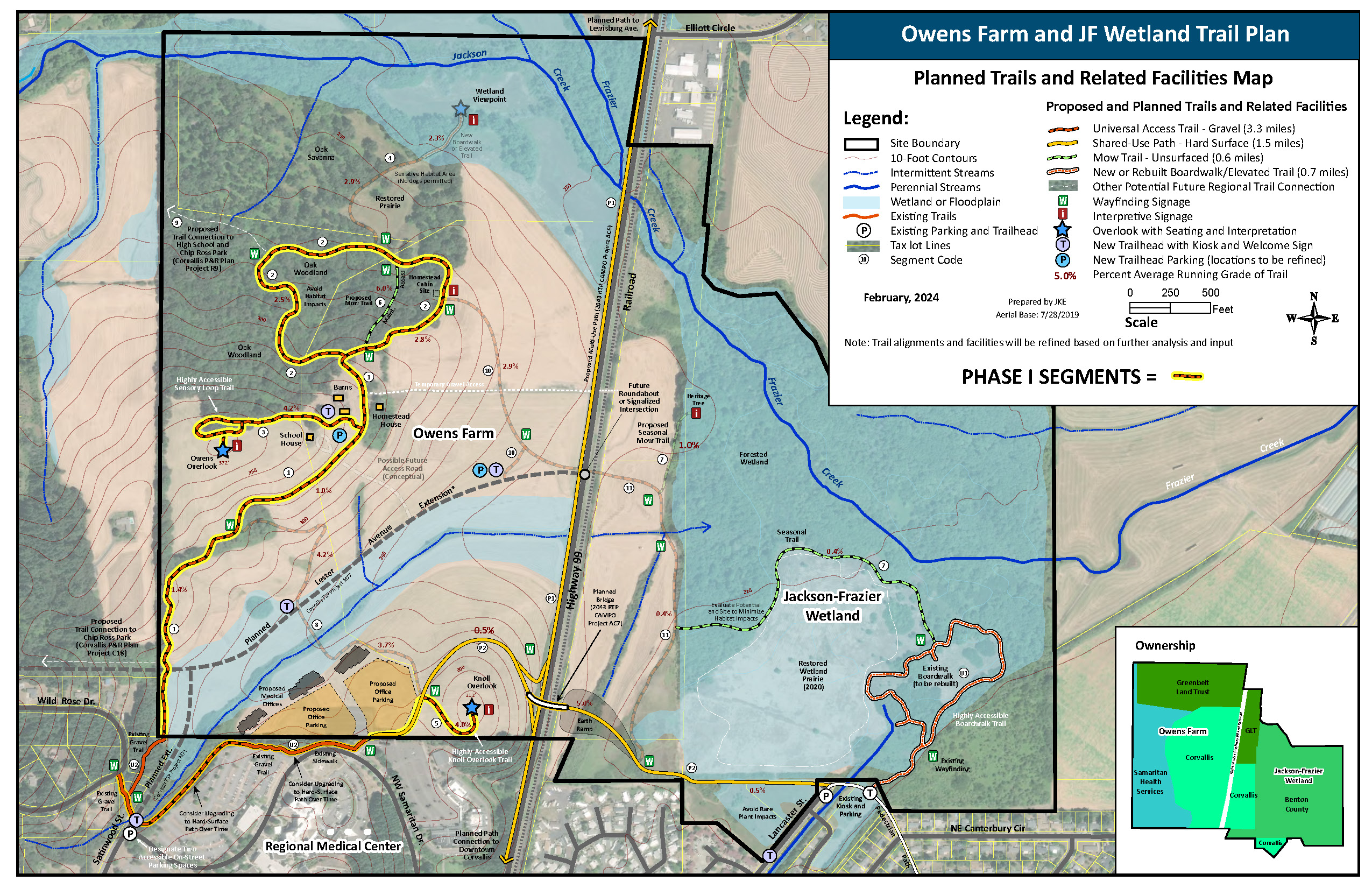
Adjacent to our community pathways project area, just north of Corvallis, the Owens Farm and Jackson-Frazier Wetland offer both existing trails and plans for expanded connections. The four-acre Jackson-Frazier Wetland features a 0.7-mile accessible boardwalk loop that winds through diverse habitats.

The 131-acre Owens Farm is being transformed into a public recreation space, with two new trails in development and plans for a future bridge linking the farm directly to the wetlands.

A key piece of a regional trail network

Our community pathways project is part of a larger vision for a connected trail system in Benton County. This network will link Owens Farm and Jackson-Frazier Wetlands to surrounding neighborhoods, schools, parks and natural areas. Located just north of the Good Samaritan Regional Medical Center and is divided by OR 99W and a parallel railroad, the area is within a half-mile of four public schools. The proposed shared use path network could eventually connect downtown Corvallis with Jackson-Frazier Wetland, Owens Farm, Chip Ross Park, McDonald-Dunn Research Forest and Adair Village.​

Building trails together

This effort is a collaboration to create an accessible trail network that promotes community health and wellbeing by improving access to nature and expanding active transportation options.

Owens Farm and Jackson Frazier Wetland Trail Plan map showing planned trails and related facilities

The project is ongoing and will include community engagement at various points before completion in winter 2026.

We started work on this plan earlier this year and will continue the planning and design process through winter 2026. 

From now through 2026, we are: 

  • Developing path alternatives through summer 2025 – your input can help us decide the best alternative for you and your community! 
  • Meeting with key interested parties – which includes about 12 people from the city, county and other groups – in summer and fall 2025 to get their feedback about our path alignment alternatives. 
  • Meeting with the Benton County Board of Commissioners in fall 2025 to define which north-south path to move forward with. 
  • Refining the preferred north-south and east-west path to 30% design. This means we'll figure out what the final overall footprint for the path will be and what areas will need to be purchased as part of the right-of-way process. 
  • Continuing to reach out to you and your community to get your feedback.
    Stay tuned and sign up to get email updates​ – we plan on having a second in-person and online open house in early 2026. 
  • Presenting to the County Board of Commissioners in spring 2026 to request their support to finalize our design. 

In the future, the county and key interested parties will be able to use the finished plan to pursue funding to finish the design process and construct the new paths.