 Back to the Open House
 Browse by Region
 Provide Feedback
 About the Map
Explore the map below to view the projects included in the 2027-2030 STIP. You may also use the button above to browse by region.
If you want to comment on any of these projects make a note of the project name or the "key number."
Using the Interactive Map
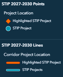
Projects are marked in one of two colors: orange or teal. Orange markers designate projects highlighted in this open house.
Circles mark projects occurring at a single location or milepoint, such as a culvert replacement or roundabout installation. Projects occurring along a section of highway, like a paving project, are marked by lines.
Select any marker to access information about the project including the name, a unique ID (key number), the phase and a brief description of the work. Projects marked in orange will also include a link to learn more about the project.
If you want to comment on a specific project, make a note of the project name or the key number. This will help us process your feedback.
Troubleshooting
Need to reset the map? Find and select the house icon, or refresh the page.