Planning for the future in Dallas
As Dallas grows, so will the demand on its transportation system. The future conditions analysis looks 20 years ahead to understand where new households and jobs are expected, how traffic patterns may change and where improvements will be needed.
Learn more by clicking on the titles or the plus signs below.
Household and employment growth within Dallas is expected to continue over the next 20 years. By 2045, the city is expected to have approximately 2,260 new households and 1,989 new jobs.
Click on the images below to enlarge.
Future traffic conditions in Dallas are expected to be impacted by growth in households and employment.
Future traffic volumes along E Ellendale Avenue and Kings Valley Highway are expected to grow by up to 30% over the next 20 years.
Several intersections along these streets are expected to approach or exceed their mobility standards and targets by 2045.
Click the image below to enlarge.
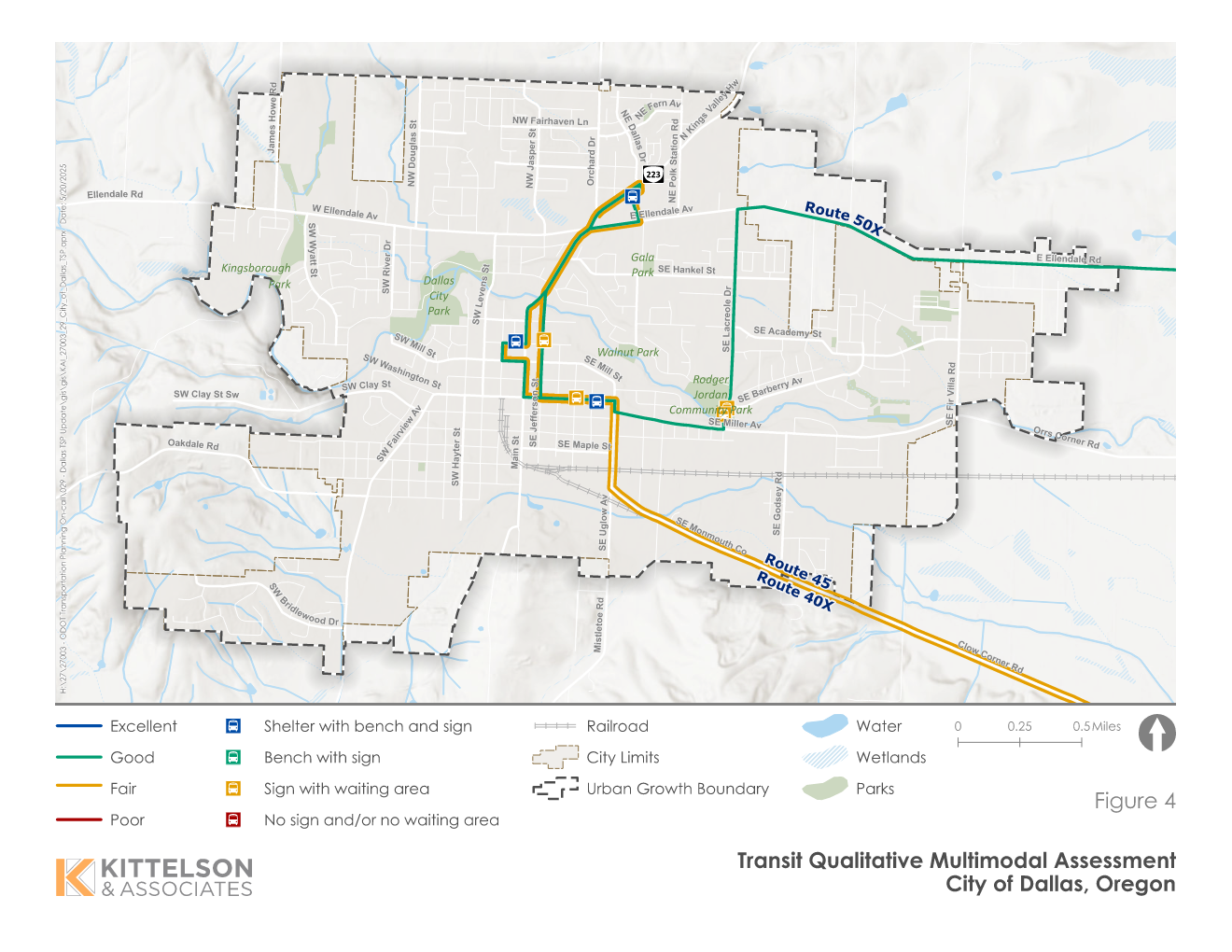
The Cherriots Long Range Transit Plan from 2022 doesn't include increased service on any of the three routes that serve Dallas. Public transit service is expected to remain the same through 2045.
An assessment of the service shows that the overall ratings for Route 40X and Route 45 is fair, while the rating for Route 50X is good. These types of ratings are typical for cities the size of Dallas.
|
Route |
Frequency
and On-Time
Reliability |
Schedule
Speed/Travel
Times |
Transit Stop Amenities |
Connecting Pedestrian/
Bicycle Network |
Overall
Rating |
| Route 40X |
Poor
(60+ min
headways) |
Excellent
(<20% slower
than driving) |
Fair
(3 stops with shelters,
benches, and signs, 2 stops
with signs and waiting area) |
Fair
(Substandard shoulders or
bike lanes and sidewalks
with no crossing) |
Fair |
| Route 45 |
Fair
(30 to 60-min
headways) |
Good
(20% to 40%
slower than
driving) |
Fair
(3 stops with shelters,
benches, and signs, 2 stops
with signs and waiting area) |
Fair
(Substandard shoulders or
bike lanes and sidewalks
with no crossing) |
Fair |
| Route 50X |
Fair
(30 to 60-min
headways) |
Excellent
(<20% slower
than driving) |
Fair
(3 stops with shelters,
benches, and signs, 4 stops
with signs and waiting area) |
Fair
(Substandard shoulders or
bike lanes and sidewalks
with no crossing) |
Good |
Click the image to enlarge.
While the city continues to expand its pedestrian and bicycle systems, several streets are expected to continue to have gaps and deficiencies that create challenges for people walking and biking.
An assessment of the pedestrian and bicycle systems shows that several streets are expected to have moderate to high stress. The target for most streets in Dallas is to make them comfortable for most adults, except near schools, where the target is to make them safe and comfortable for all pedestrians, including children.
Click the images below to enlarge.
Share your thoughts and experiences
Please use the
interactive map to identify roads and intersections that you feel are congested or unsafe for driving, walking, biking and accessing public transit.