About
The Mt. Hood Multimodal Transportation Plan built on previous planning efforts to identify ways to enhance traveler access and help reduce congestion in the short-term (five years), as well as long-term (15 years) from 2014.
Some transportation demand management programs included in the plan, include:
- increased transit.
- intelligent transportation systems.
- carpooling.
- “one stop” traveler information.
- cell coverage expansion.
- on-going transit-recreation provider coordination.
The project also looked at high-crash locations and considered additional highway safety projects for all users (vehicles, cyclists and pedestrians). The outcome of the project was a set of recommended programs and projects, along with an implementation/action and funding strategy.
Project Charge and Core Values
Input from regional stakeholders, partner agencies and the public was considered before;the options were narrowed to a final list of 38 projects; 14 of these projects were identified for early implementation based on available funding.
2022 Plan Update
ODOT is collaborating with Clackamas County, Hood River County, and US Forest Service to update the priority project list by Summer 2022.
Location
N/A
|
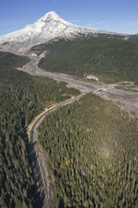
Mt. Hood Highway (U.S. 26 to OR 35) from Sandy to Hood River
Cost and Funding
This is a planning project. Projects suggested in the plan will be designed and built based on available funding.
What Problem Will This Improve?
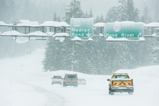
Stunning views greet the traveler along the Mt. Hood Highway (US 26-OR 35), a designated National Scenic Byway. The road provides access to an abundance of natural, cultural and historic resources. However, heavy congestion occurs during peak times, particularly winter and summer weekends.
The Mt. Hood Highway east of the City of Sandy and south of the City of Hood River is an ODOT-designated Safety Corridor due to its relatively high volume of crashes — most occurring in winter during inclement weather. Congestion is made worse by poor weather conditions and crashes. ODOT has been working with agency and community partners to increase education and enforcement along the Mt. Hood Highway Safety Corridor.