 A permit is often required to remove or fill materials in Oregon streams, side channels, and adjacent wetlands that have been mapped as Essential Salmonid Habitat (ESH).
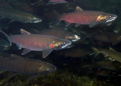
The ESH designation protects the streams where salmonid species lay eggs and where young fish grow before traveling to the ocean. Chum, sockeye, Chinook, and coho salmon, as well as steelhead and coastal cutthroat trout are all sensitive, threatened, or endangered salmonid species whose habitat may be designated as essential.
The Department of State Lands maintains
Oregon's official essential salmonid habitat map. The map uses scientific data from the Oregon Department of Fish and Wildlife to identify areas that are critical for salmonids to thrive and
require a permit to remove or fill any material.
Permit Requirements
Under Oregon state law, a
DSL removal-fill permit is required for projects that remove or place
any amount of material into the beds or banks of ESH designated waterways and some wetlands. Types of projects that likely require a permit include:
Annual Review: Map Updated for 2026
DSL has updated the Essential Salmonid Habitat map for 2026, reflecting current Oregon Department of Fish and Wildlife habitat data. Statewide, an estimated 45 additional stream miles have been added as essential habitat and about 4 stream miles will no longer be designated essential habitat. This change from 2025 to 2026 represents less than a 1% change to the overall 22,000+ stream miles of essential habitat.
See the general announcement and F.A.Q here (PDF).
Propose Edits to the Map Year-roundYou can propose map edits through the
ESH Review Request Form at any time of the year. Proposed edits should correct map inaccuracies – for example, if the mapping does not reflect current on-the-ground conditions, or if there is a new barrier that prevents fish from reaching an area. Reviews of edit requests may take more than a year to complete. Proposed edits, if accepted, would be included in the next annual map update.
Join the ESH Email List