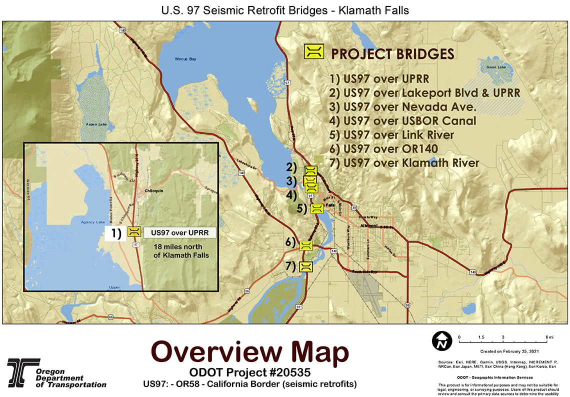
This project will improve the seismic resiliency of U.S. Hwy. 97 so the highway can continue its role as a primary north-south lifeline route in the aftermath of a major earthquake. Scientists believe a 9.0 magnitude earthquake is likely when the next Cascadia subduction event, or “Big One" strikes the Pacific Northwest coast. Many geologists believe this not only possible, but overdue.
Most of the bridges in western Oregon are expected to suffer serious damage or destruction in a major earthquake. Since the expected ground-shaking in Central Oregon is expected to be lower than that which will be experienced in the Willamette Valley and Oregon coast, the state of Oregon will look to U.S. 97 to absorb the extra traffic pressure and function as a critical transportation corridor in the days and weeks following a major earthquake.
For these reasons, U.S. 97 is designated as a Tier 1 lifeline route. Tier 1 lifelines are the most critical highways in Oregon, because they are a backbone system to provide supplies to the parts of the state most vulnerable to the Cascadia seduction earthquake.
Although Central Oregon faces lower risks of catastrophic impacts from a Cascadia earthquake than the Willamette Valley and the Oregon coast, this area is not immune to earthquake damage.
In addition to the expected Cascadia seduction event, Klamath Falls is also subject to localized earthquake activity that poses additional risks for Klamath area bridges. The Klamath Falls area, for example, has a history of significant earthquake activity, most notably magnitude 5.6 and 5.9 earthquakes in 1993.
In order to ensure that U.S 97 remains a resilient north-south highway corridor, ODOT determined that seven bridges in the Klamath Falls area are highly vulnerable to earthquake damage. ODOT decided it is necessary to retrofit six bridges and replace one – the Pelican City Bridge.
Bridges in the Klamath Falls area have been carefully evaluated, and the following bridges have been identified as the most crucial where the project improvements will be performed.
The following bridges are included as part of this project:
BRIDGE NUMBER | BRIDGE NAME | BRIDGE LOCATION | Federal index number |
BR02474B | US97 over UPPR (Lobert) | MP 252.52 | 02474B004 25252 |
BR08352 | Pelican City Bridge | | 08352 004 27299 |
BR08344 | US97 over Nevada Ave. | | 08344 004 27362 |
BR08345 | US97 over USBR Canal | | 08345 004 27371 |
BR08347 | Links River Bridge | | 08347 004 27506 |
BR09694 | Green Springs Interchange | US97 over US20 | 09694 004 27713 |
BR01895A | Klamath River Bridge | | 01895A00427869 |
Seismic retrofit measures include:
- Spread footing strengthening
- Pile cap strengthening
- Micropile and/or drilled shaft installation
- Joint modifications
- In-fill walls
- Link beams
- Shear lugs and cable restrainers
Constraints
In water work windows for Link River and Klamath River.
Three of the structures are over railroad crossings. Coordinate with BNSF and Union Pacific at these locations.
Summary of the work being done to each bridge:

Pelican City Bridge - During project development ODOT looked at retrofitting the current bridge but due to high repair costs and future maintenance costs, decided to replace the bridge. This will be accomplished will be accomplished by closing U.S. 97 for up to six weeks and using accelerated bridge construction to remove the existing bridge and build a new one in the same place. Typically replacing a bridge with conventional bridge replacement methods takes around six months (or longer). Accelerated bridge construction shortens the im
pact to the traveling public. For this bridge, much of the new structure will be constructed below the existing bridge. Once the new bridge is in place, the roadway leading up the bridge will be constructed and guardrail installed. Once all the safety elements are completed, the roadway will be reopened to traffic. While the highway is closed a detour for trucks and passenger vehicles will be in place.
US97 over Nevada Avenue - This bridge is just to the south of the PelicaCity Bridge. This bridge will require two main retrofit elements. The first are drilled shafts at behind the south end of the bridge. During drilled shaft construction, two lanes of traffic will be closed and traffic on U.S. 97 to be shifted to one side of the bridge to allow the construction contractor to work from the roadway to install the drilled shafts. The second retrofit element consists of enlarging the footings (under the ground) for interior bents on either side of Nevada Avenue. This will require shift Nevada Avenue traffic to one side, and then the other, to allow construction on the footings. During that time, the turn lane in the middle of the road will be closed. Staging to occur on Nevada Avenue under the bridge.
U.S.97 over the USBR Canal - This bridge is just to the south of the U.S. 97 over Nevada Avenue Bridge. This bridge will have two types of retrofits, those above the bridge on U.S. 97, and the other below the bridge. Within the U.S. 97 roadway, drilled shafts will be installed at the bridge ends. Similar to the Nevada Avenue Bridge, this will require closing two lanes temporarily and shifting traffic to one side of the bridge. Beneath the bridge, one support will be strengthened by installing micropiles through the existing footings. Additionally, various connections between the bridge deck and the supports will also be strengthened at all bridge supports.
U.S.97 over the Nevada Ave Bridge and USBR Canal Bridge are so close together that traffic control for both bridge will be coordinated into one stage/impact to the U.S. 97 traffic.
U.S. 97 over the Link River and Main Street - This is by far the most complex retrofit in this bridge bundle. Bridge replacement isn't an option with the current funding so the construction contractor will be essentially be strengthening or completely replacing all of the bridges supports. In addition, connections between the bridge deck and supports will be will also be strengthened. On U.S. 97, drilled shafts will be installed behind each end of the bridge, including the southbound off-ramp. During this time, traffic will be restricted to one lane due to the narrowness of the bridge.
Traffic will be flagged through the bridge, one direction at a time. While installing the drilled shafts behind the southbound off-ramp, the ramp will be closed, with traffic detoured down to OR66/Green Springs Highway Interchange. Beneath the bridge, construction project work will be extensive, and will require Conger Avenue to be closed for about a year. Local access will still be allowed during this period. During the road closure, support strengthening will take place including installing micropiles through footings, enlarging and strengthening columns, and installing restrainer cables and keys to better connect the deck onto the supports.
Main Street will be narrowed to two lanes and shifted to the south to allow the adjacent road to be replaced completely. In addition, the western access road to Veterans Park will be temporarily closed to allow access to the five supports in the Link Riverthat are being replaced entirely. Due to limitations on when work can occur within the Link River, construction is expected to take about four years.
.jpg)
Green Spring Interchange - This is the U.S. 97 Bridge over Highway OR66 Green Spring Highway. Retrofitting the bridge consists of strengthening the supports and the connections between the deck of the bridge and those supports. All work will be completed below the bridge, so no traffic impacts will occur on U.S.97. This will require closing a lane in each direction on OR66 to provide access to each support.
US97 over the Klamath River and BNSF railroad - This bridge has minimal retrofit work needed. Work will be completed from the highway at the north end of the bridge and from beneath the bridge at the south end. During construction, shoulders will be closed and traffic shifted to one side or the other on a daily basis. Traffic control measures will be installed daily, with the shoulders and roadway being opened at the end of each work shift.
A note for all bridges…
Many of the bridges will have existing guardrail replaced with new guardrail meeting current safety and crash standards. Also, three of the seven bridges are over railroads. All three of these bridges will have protective fencing installed to protect objects, road debris and snow from falling onto the railroad tracks and trains.
|
The seven structures included in this project were prioritized as seismically vulnerable structures along U.S. 97 and require improvements in order to maintain safety standards.
This project will complete seismic resiliency of bridges along highway U.S. 97. If a major earthquake or other substantial event occurs in Oregon, U.S. 97 will be used as the major north/south lifeline for the state.
Cascadia subduction earthquake
'Oregon's greatest natural threat '
U.S. 97 will be critical to recovery

When, not if, the next great Cascadia subduction zone earthquake strikes the Pacific Northwest, Oregon will face the greatest challenge in its history.
Oregon's buildings, transportation network, utilities, and population are not prepared for such an event. Were it to occur today, thousands of Oregonians would die, and economic losses would be at least $32 billion.
In their current condition, Oregon's buildings and lifelines (transportation, energy, telecommunications, and water/wastewater systems) would be damaged so severely that it would take three months to a year to restore full service in the western Oregon valleys, more than a year in the hardest-hit coastal areas, and many years in the coastal communities inundated by the tsunami that a major Cascadia event would cause.
While damaged infrastructure is removed, repaired, or replaced, normal economic activity will be interrupted. Some businesses may be forced to shut down or move. Some people may migrate out of the state. These kinds of spillover disruptions may permanently change the trajectory of the state and regional economies, imposing damages that dwarf those inflicted directly by the event.
So Oregon faces a very real threat of long-term economic decline arising from a Cascadia earthquake. That's why in 2013 the Oregon Legislature adopted the Oregon Resilience Plan, which assesses the current vulnerability of Oregon's infrastructure and outlines strategies and strategies for investing in improvements over the next 50 years to improve Oregon's ability to withstand and recover from an earthquake. Greater resilience means less direct damage from the event.
The impacts of an event like this on Oregon are impossible to predict accurately, but several studies have estimated damage and casualties, and those estimates give a sense for how far- reaching a disaster the next great earthquake will be. Forecasted consequences include:
- Earthquake deaths ranging from 650 to 5,000, with another 600 to 5,000 deaths due to the tsunami.
- 24,000 buildings completely destroyed, and another 85,000 with extensive damage requiring months to years of repair.
- Approximately $32 billion in economic losses.
- 27,600 displaced households.
Earthquakes in Oregon
Earthquake hazards have been recognized as one of the major natural hazards in Oregon since the late 1980s, a result of the geologic research into the Cascadia subduction zone and crustal faults. The March 1993 Scotts Mills earthquake (M5.6) and the September 1993 Klamath Falls earthquakes (M5.9 and M6.0) demonstrated the potential hazards of crustal earthquakes in Oregon. Because of Oregon's short history in dealing with seismic hazards, many fundamental issues, such as crustal fault activity and ground motion attenuation from subduction zone earthquakes, are still not well understood.
Earthquakes come from four different sources: crustal, subduction zone, intraplate, and volcanoes. The most common are crustal earthquakes, which occur along faults, or breaks in the earth's crust, at shallow depths of 6-12 miles (10-20 km) below the surface. The two largest earthquakes in recent years in Oregon, Scotts Mills (magnitude 5.6) and the Klamath Falls main shocks (magnitude 5.9 and magnitude 6.0) of 1993 were crustal earthquakes.
Great subduction zone earthquakes occur around the world where the tectonic plates that make up the surface of the earth collide. When these plates collide, one plate slides (subducts) beneath the other, where it is reabsorbed into the mantle of the earth. This sloping boundary between the two plates is the site of some of the most powerful earthquakes ever recorded, often having magnitudes of 8 to 9 or larger.
No one knows when the Cascadia seduction event will occur but Oregon's top scientists, engineers, and policy makers agree that it is possible to prevent a natural disaster from causing a statewide catastrophe through planning and investment in improving Oregon's resilience.
Earthquakes in Central Oregon
Earthquakes can and do happen in Central Oregon, as noted, particularly in the Klamath Falls area, which experiences crustal earthquakes.
Strategically, Central Oregon will be a major staging area in Oregon's response to a Cascadia seduction earthquake.
For example, Redmond Municipal Airport is a staging site for federal emergency response in Oregon. East-west corridors through the Cascades provide access to the more vulnerable parts of the state and are therefore a necessary part of the response and recovery system. Because there is far less likelihood of damage to facilities in these areas, they will be relied upon extensively after a Cascadia subduction zone event.