About
The I-5 Boone Bridge crosses the Willamette River in Wilsonville. It is an important link on I-5, which is the main north-south highway on the West Coast for international, national, state, and regional travel and freight movement. The bridge is at risk of failing in a Cascadia Subduction Zone Earthquake and is part of the state's designated Seismic Lifeline Route.
Currently, more than 126,000 vehicles including an average of 17,000 trucks cross the bridge every day. Expected population and economic growth in the region will increase the delays drivers experience in the project area due to congestion, which affects interstate and local road movements. The area has also been identified by ODOT as a high crash rate location.
ODOT is exploring solutions to these issues as part of the I-5 Boone Bridge Replacement Project. The project would replace the existing bridge with a new one that can withstand a major earthquake, enhance traffic flow and travel time reliability and improve safety connections. Additionally, the project would provide new walking and biking options over the Willamette River.
The Planning and Environment Linkages (PEL) and Climate Friendly Equitable Communities (CFEC) studies were completed in 2025. The studies served to narrow the design alternatives and refine the project definition, and included traffic analysis, design evaluation, environmental studies and community engagement.
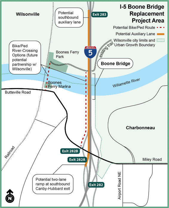
Improvements
- Replace Boone Bridge with a new bridge capable of withstanding a Cascadia earthquake event.
- Add a southbound ramp-to-ramp (auxiliary) lane between the Wilsonville Road entrance and OR 551 exit.
- Make adjustments to Miley Road (Charbonneau) interchange ramps for safer merging.
- Add wider shoulders for safety.
- Provide new walking and biking options over the Willamette River.
Technical Report and Supporting Documents
In 2022-2024, we studied how making changes to I-5 near the Boone Bridge could affect how people travel and how land is used. We put together a short version of what we found in the study along with our answers to questions about travel, land use, access and traffic. You can find this information in the project documents below.
Important discoveries from the previous work are shared in an
executive summary report submitted to the Oregon Legislature in January 2021. If you are interested in all the details about how we did the study and what we found, you can read the I-5 Boone Bridge and Seismic Improvement Project technical report.
Past Meetings and Events
- Online Open House | November 6 - December 1, 2023
- In-Person Open House | November 16, 2023, Wilsonville City Hall
- Online Open House | September 11 – 25, 2024
- In-Person Open House | September 18, 2024, Wilsonville City Hall
Project Area Map
Project Schedule
There
is no timeline for replacement since both design and construction are not
currently funded.
Location
I-5
|
I-5 at the Boone Bridge in Wilsonville
Cost and Funding
The Planning and Environmental
Linkage phase of the project was funded with $4 million. Funding for
design and construction is not available at this time.
Additional Information
Read the I-5 Wilsonville Facility Plan.
Information compiled and evaluations completed as part
of the project PEL process may be adopted or incorporated by reference
into a future environmental review process to meet the requirements of the
National Environmental Policy Act.
For ADA (Americans with Disabilities Act) or Civil Rights Title VI accommodations, translation/interpretation services, or more information call 503-731-4128, TTY 800-735-2900 or Oregon Relay Service 7-1-1.
Si desea obtener información sobre este proyecto traducida al español, sírvase llamar al 503-731-4128.
Если вы хотите, чтобы информация об этом проекте была переведена на русский язык, пожалуйста, звоните по телефону 503-731-4128.
Nếu quý vị muốn thông tin về dự án này được dịch sang tiếng Việt, xin gọi 503-731-4128.
이 프로젝트에 관한 한국어로 된 자료 신청방법 전화: 503-731-4128.
如果您想瞭解這個項目翻譯成繁體中文的相關資訊,請致電 503-731-4128.
如果您想了解这个项目翻译成简体中文的相关信息,请致电503-731-4128.