Maps for the Community Green Infrastructure Grant Program
The maps on this page are related to the directive from the legislature that the Community Green Infrastructure Program (CGI) spend 40 percent of its funds in Green Infrastructure Improvement Zones and 30 percent of its funds in tribal, rural, remote, or coastal communities. These maps identify those areas.
For the 2025 application period, Native Seed Bank, Native Plant Nursery, and Green Infrastructure Master Plan proposals must be for projects or entities in a Green Infrastructure Improvement Zone. Projects in the Community Green Infrastructure and Green Infrastructure Economic Development categories are not required be in any of the areas designated on the maps on this page – projects that are outside these areas are still eligible for funding, but for the 2025 funding round will have a much higher likelihood of receiving funds if they are in these areas.
Green Infrastructure Improvement Zones Map
Green Infrastructure Improvement Zones are made up of two parts. These zones were mapped by the Oregon Department of Forestry, in accordance with ORS 526.520.
- Pink polygons: All census tracts in Oregon that have both a high level of poverty — as established by the Climate and Economic Justice Screening Tool (CEJST) — and less than 30% tree canopy cover.
- CEJST was developed and previously hosted by the White House’s Council on Environmental Quality. It was removed from the White House website in January 2025. The Public Environmental Data Partners provide an archived version of the tool for public access.
- Purple points: The campuses of all Title I-A schools, which are schools that have a student body with a high level of poverty.
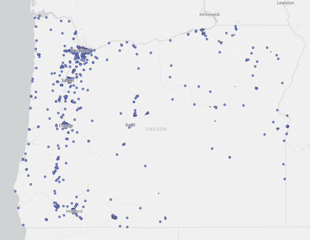
![]() Click map image to access an interactive map.
Click map image to access an interactive map.
CGI Coastal, Rural, Remote Areas Map
This map shows the areas that are designated as coastal, rural, or remote and will be used to meet the legislature's directive that 30 percent of CGI funds be allocated to tribal, rural, remote, or coastal communities. Tribal areas are not mapped because each tribe will confirm whether a project is on its reservation or trust land.
The areas were mapped as follows:
- Coastal areas, in blue, use Oregon's official coastal zone definition, established by the Oregon Legislature in 1971.
- Rural and remote areas, in green, are defined primarily by their low population and distance from urban-level amenities and services. They are all areas that are not coastal and that are farther than five miles from urban growth boundaries within a metropolitan or micropolitan area. Metropolitan and micropolitan areas were identified by using USDA rural-urban commuting area codes, which classify U.S. Census Bureau tracts based on population, urbanization, and daily commuting.
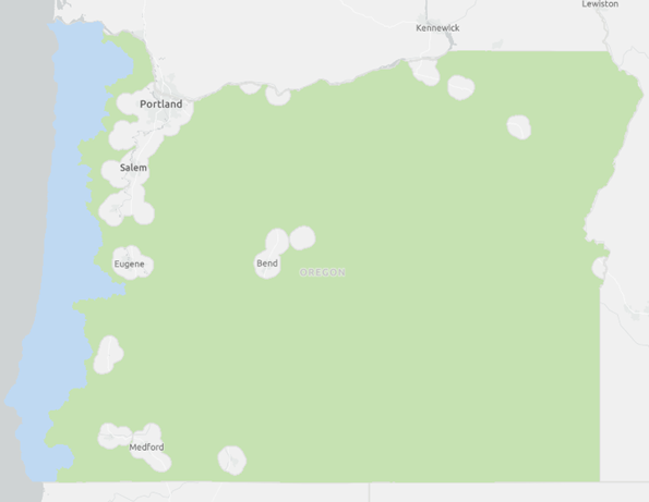
![]() Click map image to access an interactive map.
Click map image to access an interactive map.