Evaluating options for the new pathway and bridge
Our team developed options for the path east of OR 99W and the bridge over the highway and railroad. The east-west path will provide a safe and convenient way for people to walk, bike, or roll between the Good Samaritan Hospital and the Jackson-Frazier Wetland. The path options we created follow the general route we shared in previous planning maps.
The new bridge over OR 99W will need to be high enough to meet the required highway and rail clearance. The ground slopes downward to Lancaster Street, so the path needs to have a long ramp to be accessible. A gradual slope that meets ADA accessibility standards isn't just easier for those rolling in wheelchairs, pushing a stroller or riding a bike, it's also more pleasant and comfortable for all users.
Take a look below to review options we're considering for both the path and the bridge.
Click on the title or "+" below to expand the box and learn more.
We created four pathway options between the Jackson-Frazier Wetland and the bridge over OR 99W. The recommended option is called the sweeping curve. Check out the four options we developed and evaluated below. You can click on the images to enlarge.
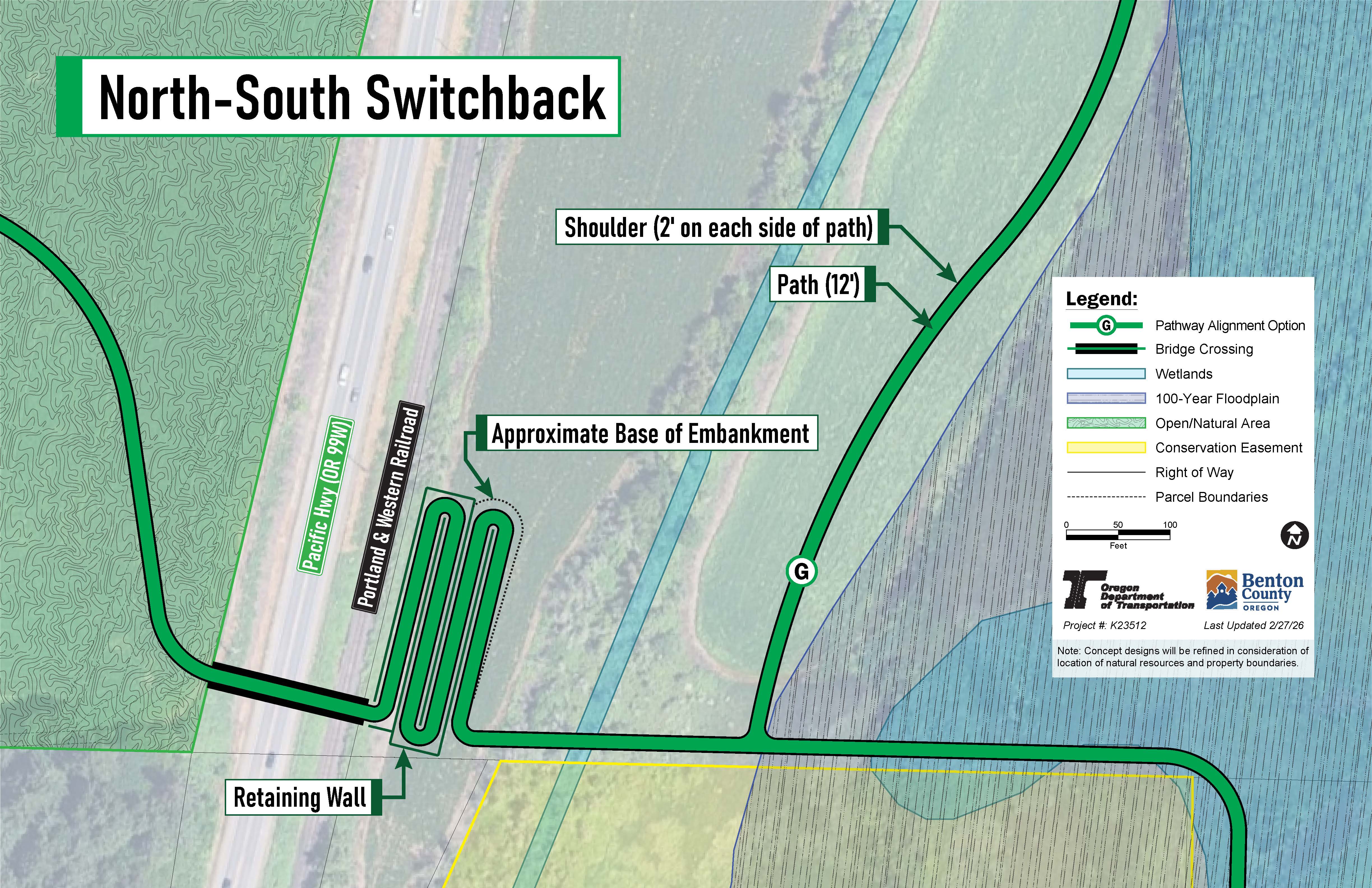
Option 1: North-south switchback
This option has the path winding north to south before reaching the bridge over OR 99W.
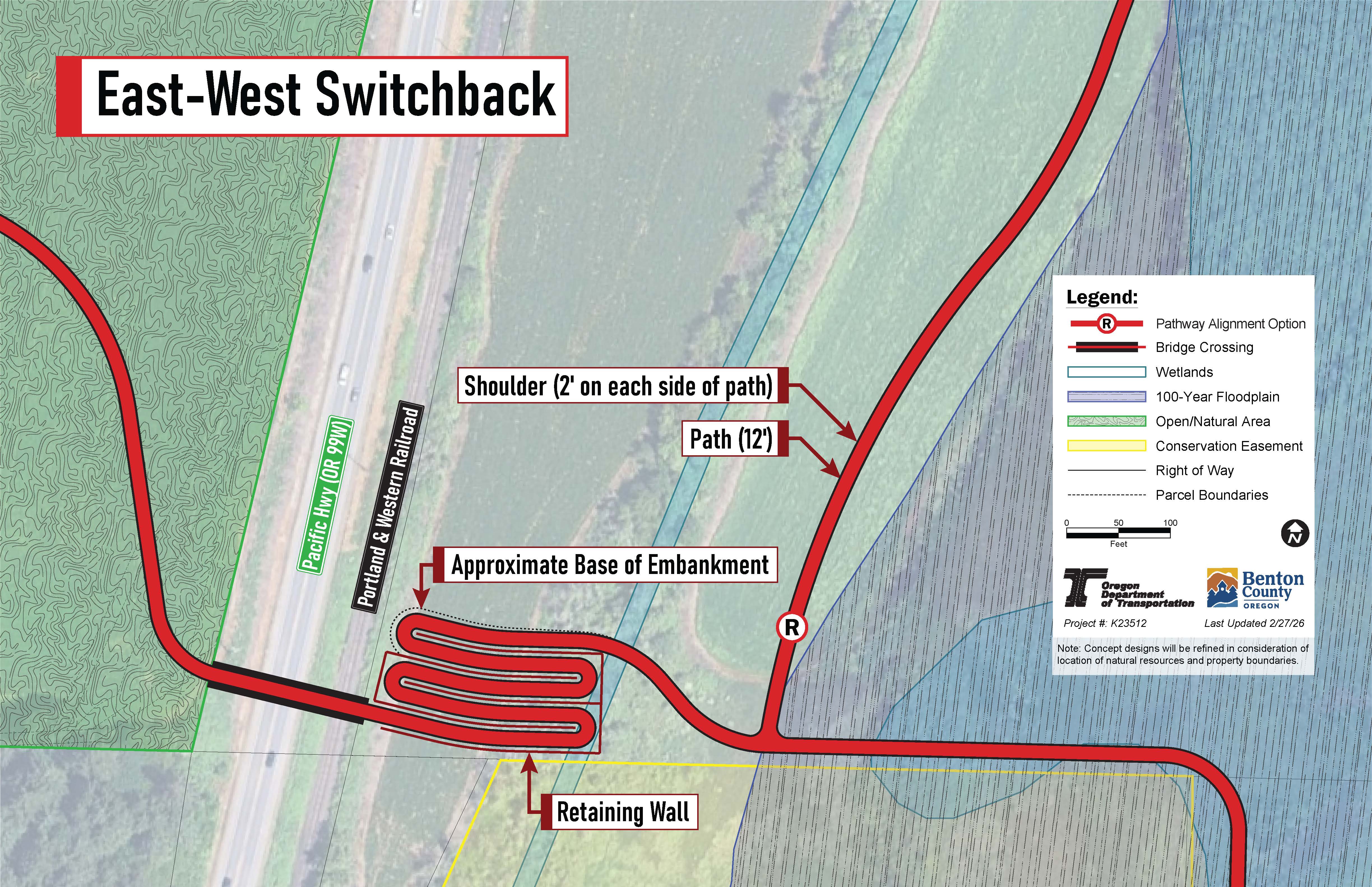
Option 2: East-west switchback
This option has the path winding east to west before reaching the bridge over OR 99W.
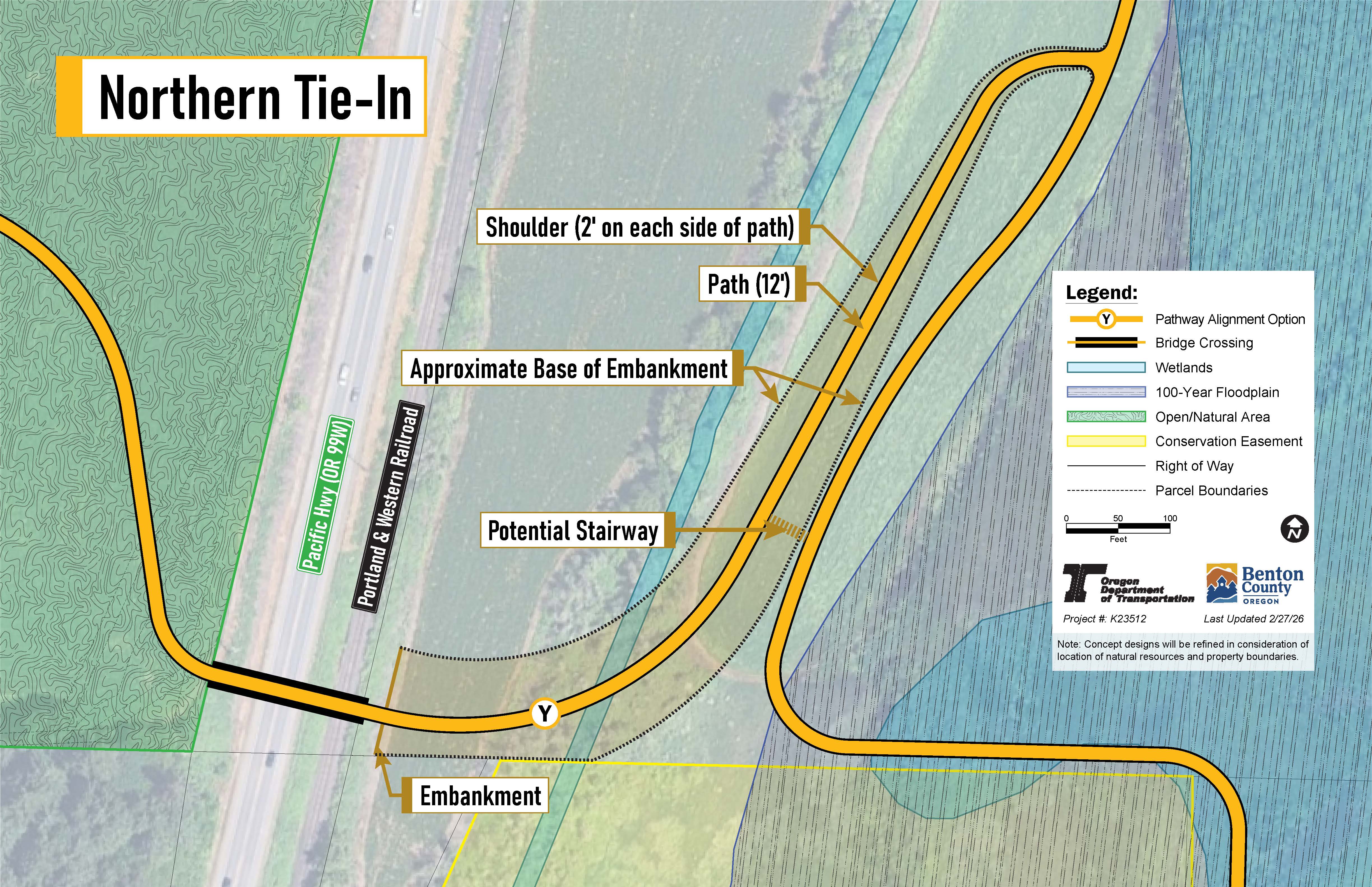
Option 3: Northern tie-in
This option has the path slope from the north down to the bridge over OR 99W.
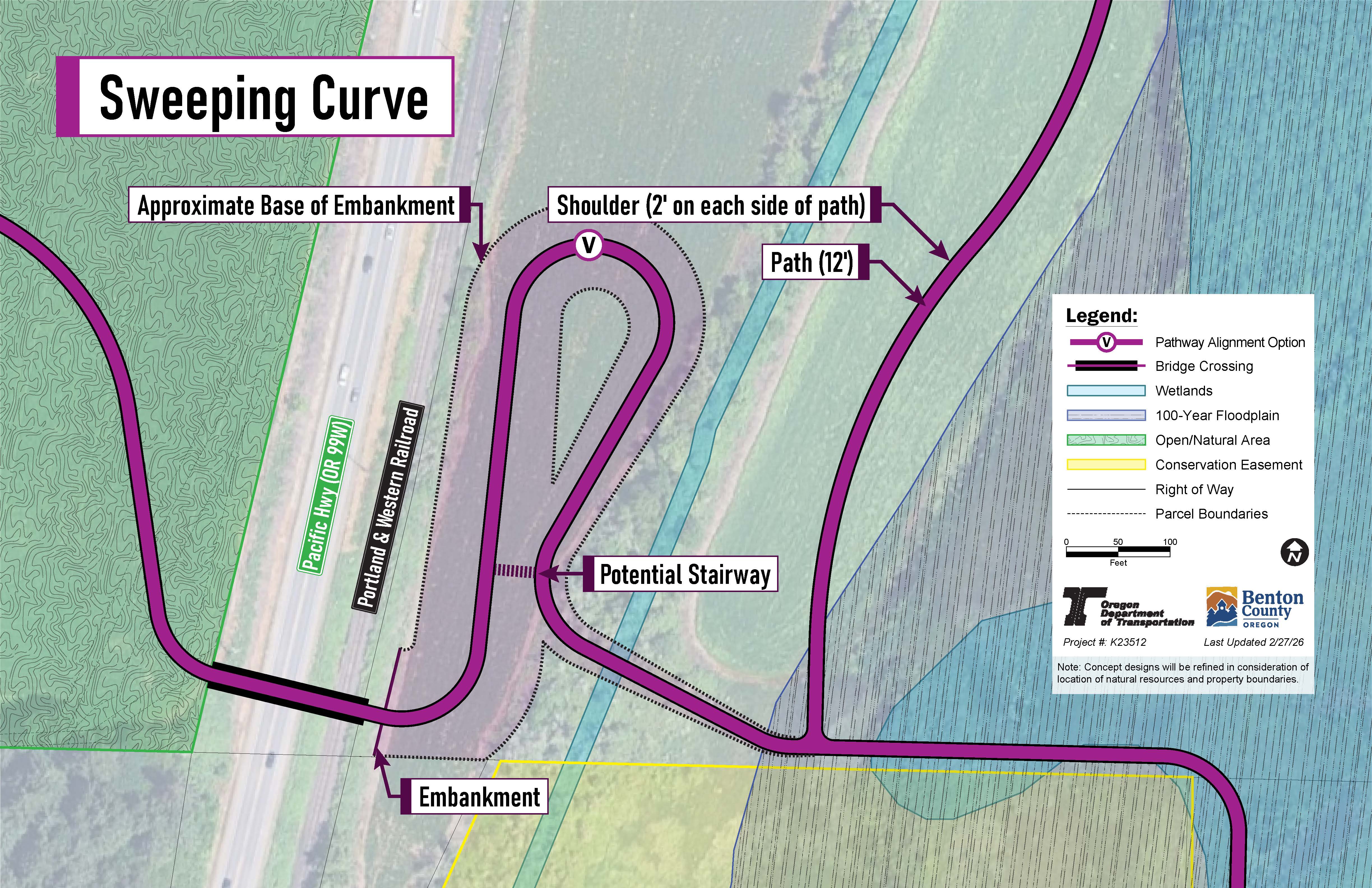
Option 4: Sweeping curve – preferred option
This option has the path sweeping north and then south before reaching the bridge over OR 99W.
We evaluated the four pathway options based on these five factors:
- Distance: The distance and travel time reflect the ease in connecting parks, schools, businesses and homes. The distance is from the east end of the bridge to Lancaster Street.
-
User experience: Perceived comfort, safety and enjoyment, consideration of conflicts between people walking and biking and design criteria.
-
Disturbance area: Measured in square footage,this is an estimate of the amount of land that the path will use.
-
Environmental impact: The impact on wetlands, floodplains and other environmentally sensitive areas.
-
Estimated cost: An estimate of the cost to build the path, which includes materials like retaining walls and building up the land to the right elevation. Each of the paths will require the use of retaining walls and building up the land.
Distance
| 2,700 feet = about a 10-minute walk
| 2,700 feet = about a 10-minute walk
| 3,200 feet = about a 12-minute walk
| 2,700 feet = about a 10-minute walk
|
|---|
User experience
| 🙂
| 🙂
| 🙂🙂
| 🙂🙂🙂
|
|---|
Disturbance area
| Less than 1 acre | Less than 1 acre
|
About 2 acres | About 2 acres
|
|---|
|
Environmental impact | ❌❌
| ❌
| ❌❌
| ❌
|
|---|
Cost
| 💲💲💲
| 💲💲💲
| 💲 | 💲 |
|---|
Based on the evaluation, the sweeping curve option is recommended.
Based on the evaluation results, the recommended pathway is the sweeping curve option.
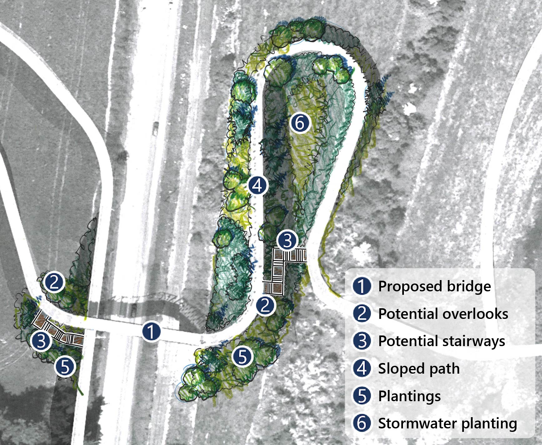
Starting from the east side of OR 99W near Lancaster Street, the path winds north and then south, sloping upward to reach the new bridge over the highway. The path continues to connect to the Good Samaritan Regional Medical Center on the west side of OR 99W.
We're looking at including two potential stairways:
- One to the east of OR 99W. This stairway would connect the lower section of the path to the higher section closer to the bridge over OR 99W.
- One to the west of OR 99W. This stairway would connect the path along OR 99W to the bridge over OR 99W.
This pathway also could include an overlook, in the drawing below it is next to the stairway on the east side of OR 99W. The design would also include native plants that would blend into the surrounding area and some in the east section of the path to help manage stormwater.
 Click on the image to enlarge.
We evaluated three types of bridges: concrete girder, steel box girder and steel truss. Each of the three bridge types has a different thickness:
- A concrete girder is 8'6" thick.
- A steel box girder is 5'6" thick.
- A steel truss is 2'6" thick.
The thicker the bridge is, the taller it will need to be to meet height requirements for trains and tall vehicles to go under the bridge safely. The taller the bridge is, the longer the pathway ramp leading up to the bridge would need to be, meaning we'd need more land for the sloped path down to Lancaster Street.
- A concrete girder bridge would need to be 38 feet tall and use 170 feet of land around it.
- A steel box girder bridge would need to be 35 feet tall and use 155 feet of land around it.
- A steel truss bridge would need to be 33 feet tall and use 145 feet of land around it.
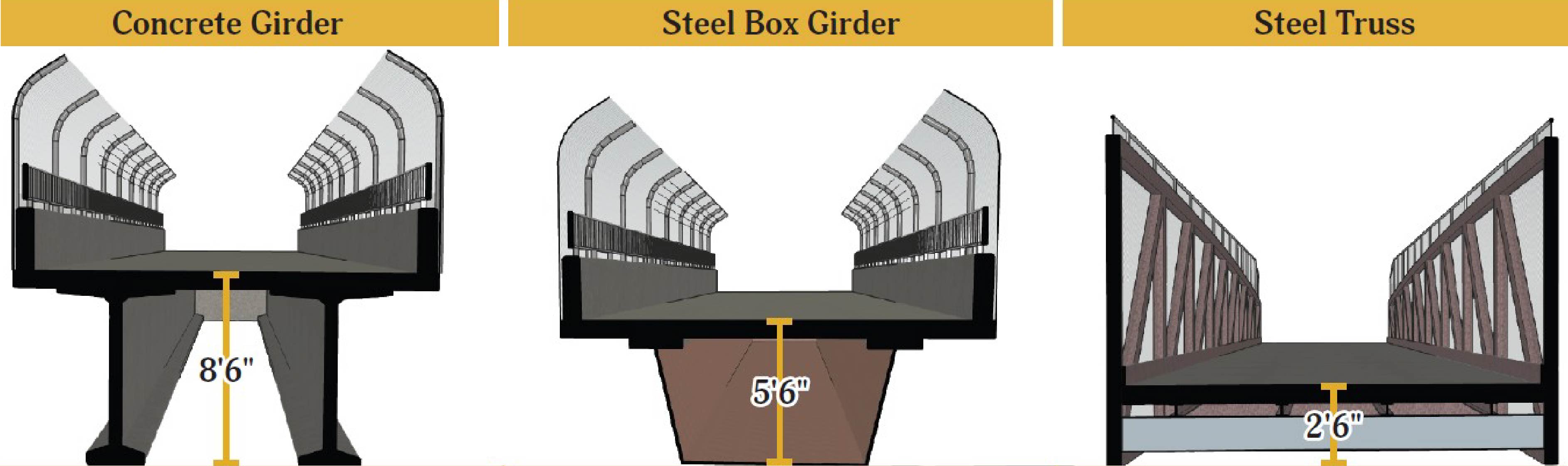 Based on these factors, the recommended option is a steel truss. It's the thinnest of the three bridges – meaning it could be lower, resulting in the shortest path to Lancaster Street and disturbing the least amount of land of the three options.