About
Between North Albany and Corvallis, U.S. 20 is a rural two-lane highway with heavy commuter traffic of more than 18,000 vehicles per day. In addition to motorists, many bicyclists use this corridor.
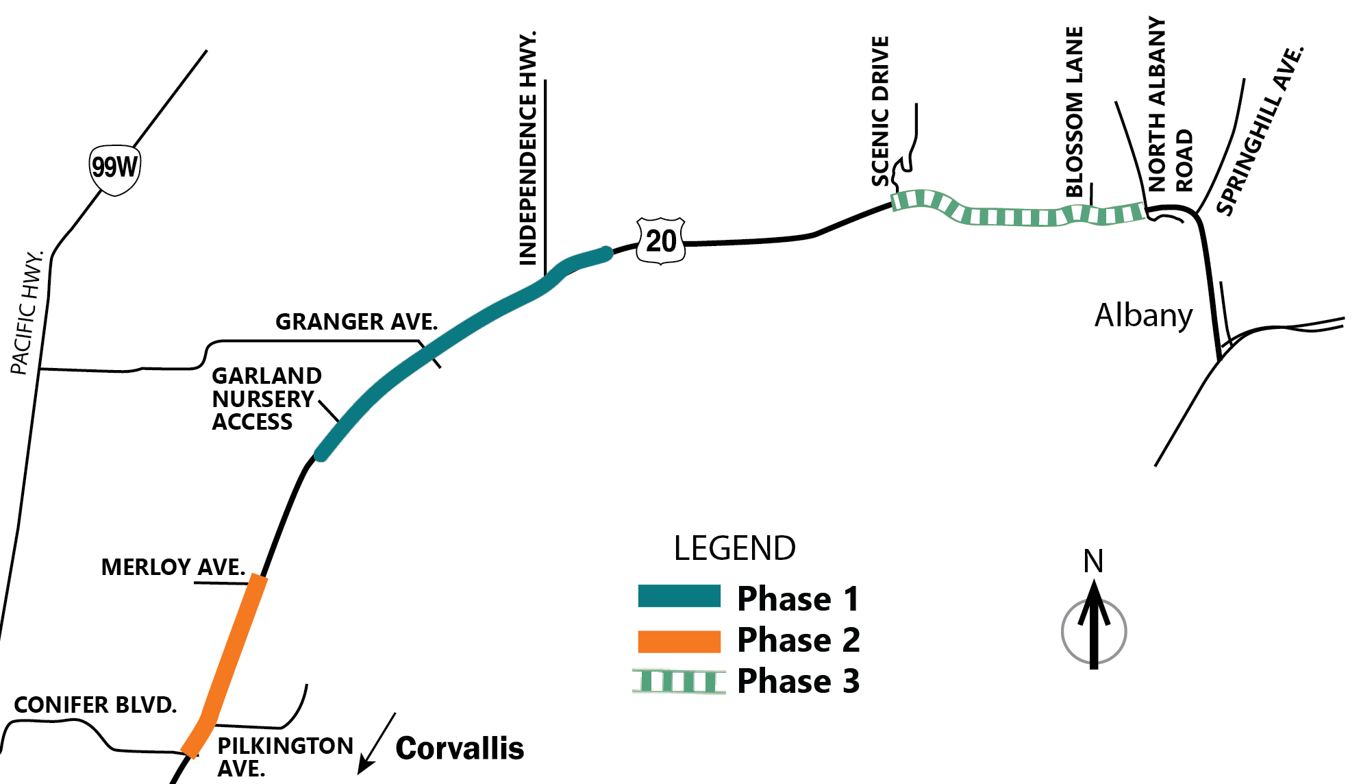
This portion of the highway had a high volume of crashes and poor visibility for travelers turning on and off U.S. 20. In 2016, we completed the U.S. 20 Highway Safety Study and recommended a variety of safety improvements along this corridor, some of which were implemented as part of this project. This work was split into three phases as shown below.

Click map image to enlarge.
Click headings below to learn more about each phase.
U.S. 20 at Granger Avenue and Independence Highway
Key Issues
- High number of crashes from cars turning onto the highway. Increased traffic reducing the number of acceptable gaps/breaks in traffic for turning.
- Limited sight distance at county road intersections due to right turning vehicle queues.
- Limited distance between highway and railroad.
Improvements
- Installed a buffered right turn lane (westbound).
- Installed a median acceleration lane for left turning vehicles (eastbound).
- Added striping and signing to guide bicycles through the intersections.
- Upgraded signing and striping for railroad crossings.
- Added centerline and shoulder rumble strips.
- Stormwater treatment.
- Built a short section of multiuse path above a new 20+ foot high retaining wall at Independence Highway for forward compatibility with the planned Benton County Bikeway.
U.S. 20 near Garland Nursery
Key Issues
- Vehicles heading westbound run off of the road at the outside edge of curve.
- Rear end crashes when vehicles slow down to enter the nursery. Improvements
- Widening shoulders.
- Adding centerline and shoulder rumble strips.
- Raising the outside edge of the pavement on the curve.
- Remove fixed objects (trees or poles) near the outside of the curve/north side of the highway where possible.
Improvements
- Widened the shoulders.
- Added rumble strips. Rumble strips are grooves cut into the pavement that create sound and vibration when they are driven over to alert the driver that they are leaving the lane.
- Raised the outside edge of pavement on the curve.
- Removed fixed objects, like trees or poles, near the outside of the curve/north side of the highway as possible.
Conifer Boulevard to Merloy Avenue
Key Issues
- Rear end and turning crashes due to slowing vehicles and limited gaps.
- Large number of highway accesses/driveways.
Improvements
- Added a center two way left turn lane.
- Treated stormwater runoff.
- Replaced sidewalks with a short section of multiuse path on the east side between Conifer Boulevard and NE Pilkington Avenue for forward compatibility with the planned Benton County Bikeway project currently in development.
Key Issues
- Rear end and turning crashes due to slowing vehicles and limited gaps.
- Large number of highway accesses and local roads.
Proposed Improvements
- Adding a center two way left turn lane.
- Adding and replacing guardrail where needed.
- Widening shoulders.
- Bicycle and pedestrian improvement alternatives are being coordinated with the City of Albany and Benton County.
- Stormwater treatment.
Note: No funding has been identified for final design or construction at this time.
Schedule
Phase One: Completed
Phase Two: Completed
Phase Three: Field work and conceptual design completed.
Location
U.S. 20
|
Conifer Boulevard near Corvallis to North Albany Road
Cost and Funding
Total funding for all phases: $28.2 million
$20 million came from House Bill 2017.
Additional Resources
Learn more about:
This project is associated with three project numbers in the Statewide Transportation Improvement Program: 21191, 23302 and 23596.