Project Background
Purpose
Publication
Acknowledgments and Funding
Map Viewer Development
Purpose
In September 2009 the U.S. Geological Survey (USGS) Cascades Volcanic Observatory (CVO) solicited proposals to use funds from the American Recovery and Restoration Act (ARRA) for a multi-hazard study of the Mount Hood area (study area extent: Plate 1 [preview]). The Oregon Department of Geology and Mineral Industries (DOGAMI) submitted a proposal entitled ?Multi-hazard risk and vulnerability assessments at select drainages around Mount Hood (OR) using methodologies that would be applicable to other volcanic areas.? That proposal was accepted and this project was funded through USGS Award Number G10AC00029. This study was completed between January 2010 and September 2011.
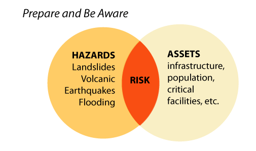
The main purpose of this project was to help communities on or near Mount Hood become more resilient to geologic hazards by providing accurate, detailed, and up-to-date information about hazards and about community assets at risk. A second purpose was to explore hazard and risk analysis methodologies that could be applied to other volcanic areas.
The main objectives of this study were to:
- Acquire input from stakeholders regarding hazard, asset, and risk analysis needs through a series of workshops and a pre-workshop poll
- Compile and incorporate existing data including the USGS Mount Hood Volcanic Hazards Map, Mount Hood Coordination Plan, and FEMA Pre-disaster Mitigation Plans
- Compile and/or create a database of volcanic, landslide, flood, and earthquake hazards
- Compile and/or create a database of critical facilities and essential infrastructure, generalized zoning, buildings, and population asset data
- Perform exposure and HAZUS based risk analysis
- Share the results through this report and on the web
The first task was to acquire input from stakeholders regarding hazard, asset, and risk analysis needs through a series of workshops and a pre-workshop poll. The two most significant results from the poll and workshops were the importance of infrastructure and the desire to have study data provided online.
The second task was to create a Geographic Information System (GIS) database of hazards and a GIS database of community assets. The databases, which include both complied data and data created for this project, are:
-
Volcano hazards
- Proximal hazard zone
- Lahar hazard zone
- Deposits from significant events
-
Landslide
- Large, deep-seated landslides
- Debris flow deposits
- Steep slope areas
-
Flood and channel migration
- 25-year flood zone
- 500-year flood zone
- 100-year channel migration zone
-
Earthquake
- 500-year shaking
- Liquefaction hazard zones
- Fault hazard zones
- Historic earthquake epicenters
-
Gridded population density
-
Generalized land use/zoning and buildings
- Generalized land use/zoning
- Building footprints
-
Critical facilities and primary infrastructure
- School, police, fire, and hospital buildings
- Electric transmission lines, tower locations, and substations
- Dams and wastewater treatment plants
- Railroads and rail bridges
- Airports
- Highways, arterial roads, and bridges
Learn more about these hazards and assets.
We believe that these databases are the most complete and accurate currently available; most have been created or updated using new high-resolution, high-accuracy lidar topographic data. Newly mapped or modeled results include newly modeled lahar hazard zones, almost 400 large, deep-seated landslides, over 1,000 debris flow fan areas, channel migration hazard zones, a gridded population density data, almost 47,000 buildings, 104 school and emergency response facilities, over 1,600 miles of road, 340 bridges, 944 primary electric transmission towers, and 615 miles of electric transmission lines.
We used these databases to perform hazard and asset exposure analysis and HAZUS-MH based risk analysis. There are approximately 5,000 people located in the 500-year volcano hazard zones, which is important information for evacuation planning. We also estimated that 20% of the highway miles in Hood River County are exposed to debris flow hazards.
Publication
The results of the study are available as DOGAMI Open-File Report O-11-16 [preview], Multi-Hazard and Risk Study for the Mount Hood Region, Multnomah, Clackamas, and Hood River Counties, Oregon, by William J. Burns, Kaleena L. B. Hughes, Keith V. Olson, Jason D. McClaughry, Katherine A. Mickelson, Daniel E. Coe, John T. English, Jed T. Roberts, Rachel R. Lyles Smith, and Ian P. Madin. Study results are also displayed on an interactive web map (Hazards and Assets Map Viewer). Users can browse or can fly to a community or an address, then select the full range of asset and hazard data for viewing. A
Help page explains the map viewer interface.
The DVD publication includes the following:
1. Thematic map plates (actual size 55 in x 61 in; scale 1:72,000):
Plate 1. Study Area Map [preview]
Plate 2. Volcano Hazards [preview]
Plate 3. Landslide Hazards [preview]
Plate 4. Flood and Channel Migration Hazards [preview]
Plate 5. Earthquake Hazards [preview]
Plate 6. Generalized Land Use/Zoning [preview]
Plate 7. Gridded 2000 U.S. Census Population [preview]
2. Report:
Text report to accompany plates (PDF file) is provided in two resolutions: *_print.pdf files are best for plotting; *_onscreen.pdf files are best for onscreen viewing. To view Adobe Acrobat portable document format (.pdf) files, download the free Adobe Acrobat Reader from Adobe Systems Inc., San Jose, CA. http://www.adobe.com
3. Appendices:
Appendix A. Stakeholder Survey (PDF file)
Appendix B. ShakeMap Background Information (PDF files)
Appendix C. Spreadsheets of inventory and exposure tables (as PDF and as Microsoft Excel files):
- Asset Inventory: Buildings, Zoning, Critical Facilities, Primary Infrastructure, Population
- Earthquake Exposure: Buildings, Zoning, Critical Facilities, Primary Infrastructure, Population
- Flood Exposure: Buildings, Zoning, Critical Facilities, Primary Infrastructure, Population
- Landslide Exposure: Buildings, Zoning, Critical Facilities, Primary Infrastructure, Population
- Volcanic Exposure: Buildings, Zoning, Critical Facilities, Primary Infrastructure, Population
Appendix D. HAZUS Reports - Five HAZUS-MH reports for the study area (PDF files):
- HAZUS-MH: Earthquake (earthquake module): 500-year earthquake hazard analysis
- HAZUS-MH: Volcanic (flood module): 500-year volcanic hazard analysis
- HAZUS-MH: Flood (flood module): 500-year flood hazard analysis
- HAZUS-MH: Volcanic (earthquake module): 500-year volcanic hazard analysis (without landslide/volcanic hazards)
- HAZUS-MH: Volcanic (earthquake module): 500-year volcanic hazard analysis (with landslide/volcanic hazards)
Appendix E. Stakeholder Meeting Posters (PDF files)
- Snow and Ice on Mount Hood, Hood River and Clackamas Counties, Oregon
- The Meandering and Terraced Sandy River at Oxbox Park, Multnomah County, Oregon
- The Parkdale Lava Flow, Hood River County, Oregon
Acknowledgments and Funding
The publication is the result of a proposal titled ?Multi-Hazard Risk and Vulnerability Assessments at Select Drainages Around Mount Hood (OR) Using Methodologies That Would Be Applicable to Other Volcanic Areas.? Funding for this project was provided by the U.S. Geological Survey Cascade Volcanic Observatory (CVO) through an ARRA grant(USGS Award Number G10AC00029), with some funds from the State of Oregon. We are very grateful to individuals from CVO and the Mount Hood National Forest who assisted us with data compilation and discussions. We would also like to thank all the people from city and county agencies and departments who assisted us with data compilation, attended workshops, completed the poll, and participated in discussion.
We thank people from other agencies who assisted on this project ? from the U.S. Geological Survey,
Cascades Volcano Observatory: Cynthia Gardner, Willie Scott, Tom Pierson, Carolyn Driedger, Dick Iverson, Steve Schilling, Julie Griswold, John Ewert, Seth Moran, and Evelyn Roeloffs; and from
U.S.D.A. Forest Service, Mount Hood National Forest: Tom DeRoo.
DOGAMI MAP DATA CREATION/DEVELOPMENT
Lidar: John T. English, Kaleena L.B. Hughes, Jed T. Roberts, Paul Ferro
Building Footprints: Kaleena L.B. Hughes, Keith V. Olson, Robert D. Chappell
Infrastructure Asset Data: Keith V. Olson, Kaleena L.B. Hughes
Volcano Hazards: William J. Burns
Landslide Hazards: William J. Burns, Katherine A. Mickelson
Flood Hazards: Daniel E. Coe, Kaleena L.B. Hughes, John T. English, Jed T. Roberts
Channel Migration Zones: Daniel E. Coe, John T. English, Robert D. Chappell
Earthquake Hazards: Ian P. Madin, William J. Burns, Kaleena L.B. Hughes, Rachel R. Lyles Smith
Gridded Population Analysis: Kaleena L.B. Hughes
Generalized Land Use/Zoning Analysis: Kaleena L.B. Hughes, William J . Burns
DOGAMI MAP PLATE PRODUCTION
Cartography: Rachel R. Lyles Smith
Text: William J . Burns, Ian P. Madin
Editing: Ian P. Madin
DOGAMI WEB MAP VIEWER CREATION/DEVELOPMENT
Lidar base map: Paul Ferro
ArcViewer for Flex development: Paul Ferro
Web map cartography: Kaleena L.B. Hughes
Map Viewer Version History
Study completed and released as DOGAMI
Open-File Report O-11-16.
Hazards and Assets Map Viewer deployed using Esri ArcGIS Server and ArcGIS Viewer for Flex version 2.3.1.