 Oregon has a LOT of volcanoes. You might be on one right now.
Volcanoes, like most earthquakes, are related to tectonic plate motion. Volcanoes can present many hazards, including clouds of hot gases carrying rock and sand, blast effects, ash falls, and mud flows. On the positive side, it can be said that, unlike earthquakes, volcanoes generally give plenty of warning that they are awakening—although the actual moment of eruption may come as an unpleasant surprise.
Following an eruption, ash may take weeks to settle from the air. This fine powder is quite harmful to lungs and incredibly abrasive to moving parts of any machinery or engine. The weight of wet ash can collapse a building.
Pyroclastic flows are sensational aspects of some volcanic eruptions. In such events, superhot, burning gas is suddenly pumped into the air to fall back to earth as a heavy cloud that moves across the landscape at hundreds of miles per hour, devastating everything in its path. Even though pyroclastic flows were known to geologists, they were only rarely witnessed and not filmed until the 1980s, when they were captured on videotape in Japan. In 1902 over 30,000 people in the village of St. Pierre on Martinique were incinerated by a pyroclastic flow, and more recently the island of Monserrat experienced the same phenomenon, fortunately without loss of life. In Oregon, deposits from pyroclastic flows are a frequent part of the geologic record east of the Cascades.
Before the 1980 Mount St. Helens episode, the incidence and impact of lateral eruptions was poorly understood. During this event, the northeastward blast knocked down trees and increased damage significantly. Since then, it has been found that lateral blasts are not uncommon in Cascade volcanoes. An urban center in the path of such a force would be totally devastated. In Oregon, there are very few populated areas that would be affected by a lateral blast.
Prehistoric and historic volcanic eruptions in Oregon
In the Cascade volcanic chain, that extends from Lassen Peak in northern California to Meager Mountain in British Columbia, over 3,000 large and small volcanoes have erupted during the past five million years. Within the vicinity of Portland alone, close to 50 volcanoes erupted more than half a million years ago. Between 1843 and 1860, a series of 21 eruptions took place in the Cascades. Many more youthful volcanoes are scattered across the vast expanses of central and eastern Oregon, including Newberry Volcano (near Bend) and Diamond and Jordan craters in far southeast Oregon.
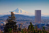
The Cascade peaks in Washington and California have erupted more recently than those in our state. Mount Hood has erupted three times over the past 2,000 years. Flows of hot ash, rock, and mud poured down the southwest side of the mountain near Crater Rock about 1,400–800 years ago, 600–400 years ago, and between 1760 CE and 1800 CE. In each event, lava reached the surface through vents, accumulated, then collapsed, sending streams of the hot debris downslope. Melting snow combined with lahars of ash, lava, rock, and mud to travel along the Sandy, Zig-Zag, and White Rivers, burying forests upright.
Predictions about future eruptions of Mount Hood have been based on observations of volcanism elsewhere. Warning times from as little as a few hours to as long as one year have been suggested as needed; but a system of seismometers, located on the mountain and recording present-day tremors, should give adequate advance notification for civil evacuation. As during earlier eruptions, molten material and an ash cloud could be expected to affect the same river valleys, and the projected hazard zone could extend to the communities of Hood River, Sandy, and Zig-Zag.
Across the Columbia River in Washington, the eruption of Mount St. Helens on May 18, 1980, devastated a wide area of the Northwest. The destruction shocked people living here and made them realize that such a violent event could easily recur.
Mount St. Helens gave substantial warning that it was to erupt. About two months prior, small earthquakes were detected by a network of seismographs, and a minor eruption on March 27 opened a summit crater. These were followed by a M 5.1 earthquake that triggered massive landslides on the north slope and brought about the rapid release of pressure on the superheated interior of the cone. The ensuing eruption took off the upper 1,300 feet of the peak. Lahars of melted snow, ice, and hot rock combined to descend the side of the volcano, and a visible plume of airborne ash was carried as far east as Denver, Colorado. Powdery gray ash fell eastward to Spokane and later south to the Willamette Valley.
Around 7,700 years ago, the eruption of Mount Mazama—now Crater Lake—in southern Oregon was more violent and would have been spectacular to any one viewing it. During the Pleistocene Epoch, over 400,000 years ago, numerous early eruptions spread individual flows of lava up to 30 feet thick. After an extended period of cone building, the stratovolcano exploded with clouds of ash and fiery debris that would have covered the present-day city of Bend 6 inches deep. Ash layers would also have accumulated on what is now Portland and the Willamette Valley. After about six cubic miles of magma had drained from the subterranean chamber, the roof collapsed into the caldera, removing approximately 2,000 feet from the mountain top. Today the beautiful blue waters of Crater Lake occupy the collapsed volcano.