Flooding in Oregon
Flooding is a widespread, common, and costly natural hazard for Oregon. The National Flood Insurance Program (NFIP) identifies 251 communities in Oregon as flood prone, including locations in all 36 counties, 212 cities, and 3 tribal nations.
The Oregon Department of Geology and Mineral Industries (DOGAMI) offers a number of services to:
- Identify and provide awareness of flood-related hazards
- Target mitigation projects to reduce flood risk
- Improve hazard mitigation, comprehensive, and climate change resilience planning
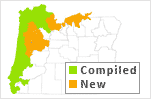
Statewide Levee Database for Oregon
The comprehensive database compiles new and existing levee information for major agricultural and urban areas of western Oregon, creating an important resource for assessing flood risk, flood mitigation planning, and emergency response during flood events.
Download the publication.
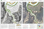
Mapping Channel Migration
Streams naturally move over time in a gradual process known as channel migration. But during flood events, significant migration can happen quickly. Channel migration has been overlooked in traditional flood insurance mapping–but DOGAMI’s new generation of maps identify the hazard.
Learn more
(last updated 07/27/2020)