DOGAMI GEOLOGIC MAP SERIES
Publication Preview
GMS-132,
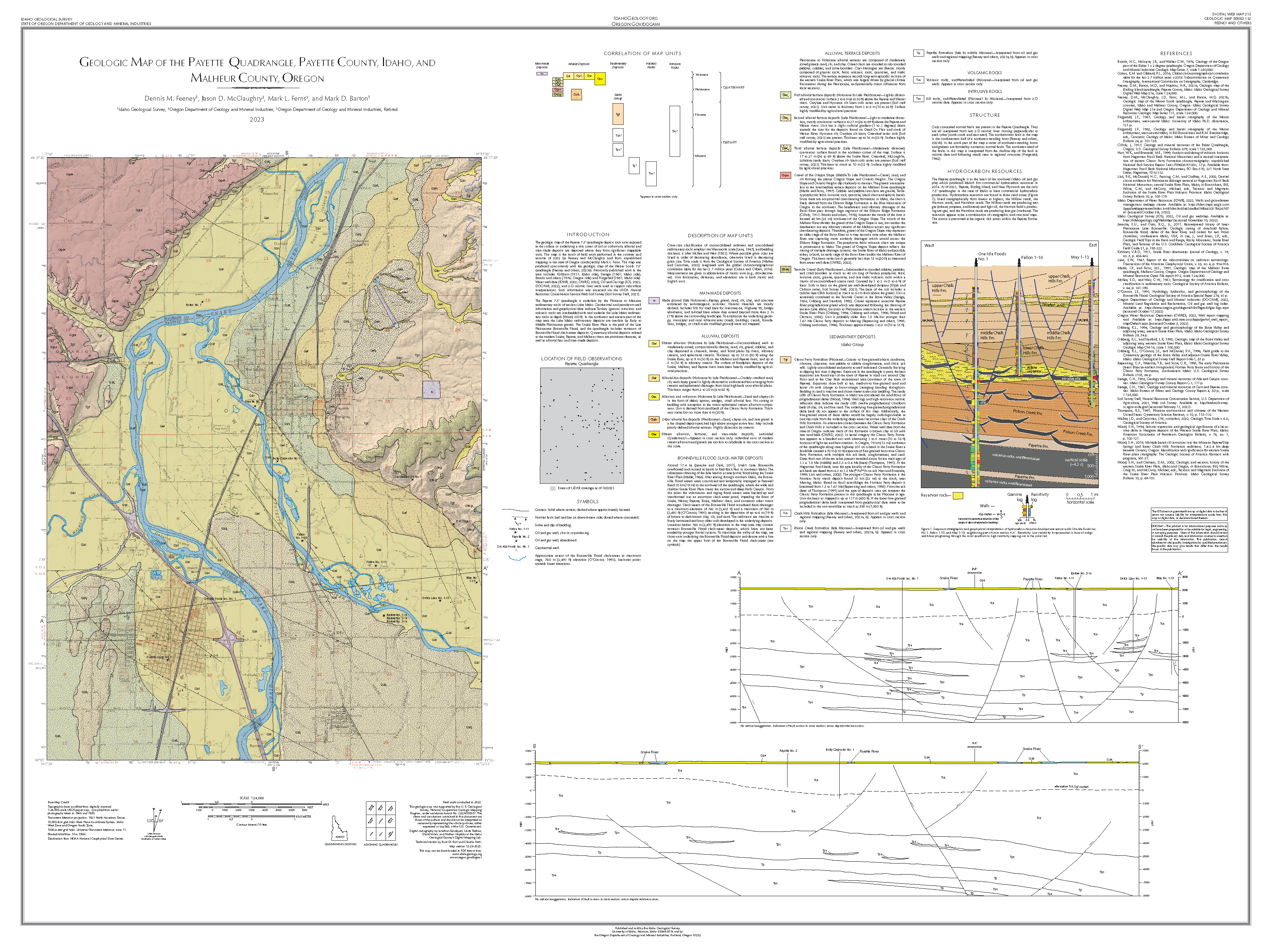
Geologic Map of the Payette Quadrangle, Payette County, Idaho, and Malheur County, Oregon, by
Dennis M. Feeney, Jason D. McClaughry, Mark L. Ferns, and Mark D. Barton; 1 map plate (scale 1:24,000), including cross sections, field photos, and explanatory text; Esri format geodatabase and metadata.
PUBLICATION DOWNLOADS
-
Map plate Geologic Map of the Payette Quadrangle, Payette County, Idaho, and Malheur County, Oregon (48" x 36"; 14.9 MB) with geologic map, explanatory text, cross sections, and field photos
-
GIS metadata (1 .xml file, 23.4 KB)
-
Full GIS data bundle, geodatabase with metadata (Esri® version 10.7 format; 1.7 MB zip file)
-
Complete publication bundle (map plate, geodatabase, metadata; 16.5 MB zip file)
INTRODUCTION
The geologic map of the Payette 7.5' quadrangle depicts rock units exposed at the surface or underlying a thin cover of soil or colluvium; alluvial and man-made deposits are depicted where they form significant mappable units. This map is the result of field work performed in the summer and autumn of 2022 by Feeney and McClaughry and from unpublished mapping in the state of Oregon conducted by Mark L. Ferns. This map was produced concurrently with the geologic map of the Weiser South 7.5' quadrangle (Feeney and others, 2023b). Previously published work in the area includes Kirkham (1931; Idaho side), Savage (1961; Idaho side), Brooks and others (1976; Oregon side) and Fitzgerald (1981; Idaho side). Water well data (IDWR, 2022; OWRD, 2022), Oil and Gas logs (IGS, 2022; DOGAMI, 2022), and 2-D seismic lines were used to support subsurface interpretations. Soils information was accessed via the USDA Natural Resources Conservation Service Web Soil Survey (Soil Survey Sta_, 2023).
The Payette 7.5' quadrangle is underlain by the Pliocene to Miocene sedimentary rocks of ancient Lake Idaho. Geothermal and petroleum well information and geophysical data indicate Tertiary igneous intrusions and volcanic rocks are interbedded with and underlie the Lake Idaho sedimentary rocks at depth (Wood, 2019). In the northwest and eastern part of the map area the Lake Idaho sedimentary deposits are overlain by Early to Middle Pleistocene gravels. The Snake River Plain is the path of the Late Pleistocene Bonneville Flood, and the quadrangle includes remnants of Bonneville Flood slack-water deposits. Quaternary alluvial deposits related to the modern Snake, Payette, and Malheur rivers are prominent features, as well as alluvial fans and man-made deposits.
GEOGRAPHIC INFORMATION SYSTEM (GIS) DATA
Geodatabase is Esri® version 10.7 format.
Metadata is embedded in the geodatabase and is also provided as separate .xml formatted files.
MAP PLATE (PDF Format)
Map plate.
Geologic Map of the Payette Quadrangle, Payette County, Idaho, and Malheur County, Oregon, scale 1:24,000, 48" x 36"