DOGAMI OPEN-FILE REPORT SERIES
Publication Preview
 Open-File Report O-25-09, Debris Flow Hazard, Risk, and Risk Reduction in the Eagle Creek, Beachie Creek-Lionshead, Holiday Farm, and Archie Creek Fire Areas, Multnomah, Hood River, Marion, Lane, and Douglas Counties, Oregon, by William J. Burns, Jon J. Franczyk, Nancy C. Calhoun, Matt C. Williams, Cynthia M. Smidt, Katherine Daniel, Christina Barrows, Taylor Cates, Jessica M. Wilder, and Laura L.S. Gabel; 43 p. report, four PDF fact sheets, four PDF road maps to risk reduction, four appendices (each including a PDF and Esri® geodatabase with internal metadata and external metadata in .xml format).
WHAT’S IN THIS REPORT?
This paper evaluates channelized debris flow hazard and risk within the 2017 Eagle Creek Fire and the 2020 Beachie Creek-Lionshead, Holiday Farm, and Archie Creek fires, Oregon. The intended audience for this paper includes those in government, industry, academia, and the public.
PUBLICATION DOWNLOADS
-
Text report (43 p., 6.4 MB PDF)
-
Appendix A: Eagle Creek Fire (1 PDF, 1 geodatabase, 16 .xml files, 68.3 MB .zip file)
-
Appendix B: Beachie Creek and Lionshead Fire (1 PDF, 1 geodatabase, 19 .xml files, 86.9 MB .zip file)
-
Appendix C: Holiday Farm Fire (1 PDF, 1 geodatabase, 19 .xml files, 104.4 MB .zip file)
-
Appendix D: Archie Creek Fire (1 PDF, 1 geodatabase, 19 .xml files, 38.5 MB .zip file)
-
Roadmaps to risk reduction (4 PDF files, 7.5 MB .zip file)
-
Postfire debris flow fact sheets (4 PDF files, 189.4 MB .zip file)
-
Complete publication bundle (500.9 MB .zip file)
INTERACTIVE WEB MAPS
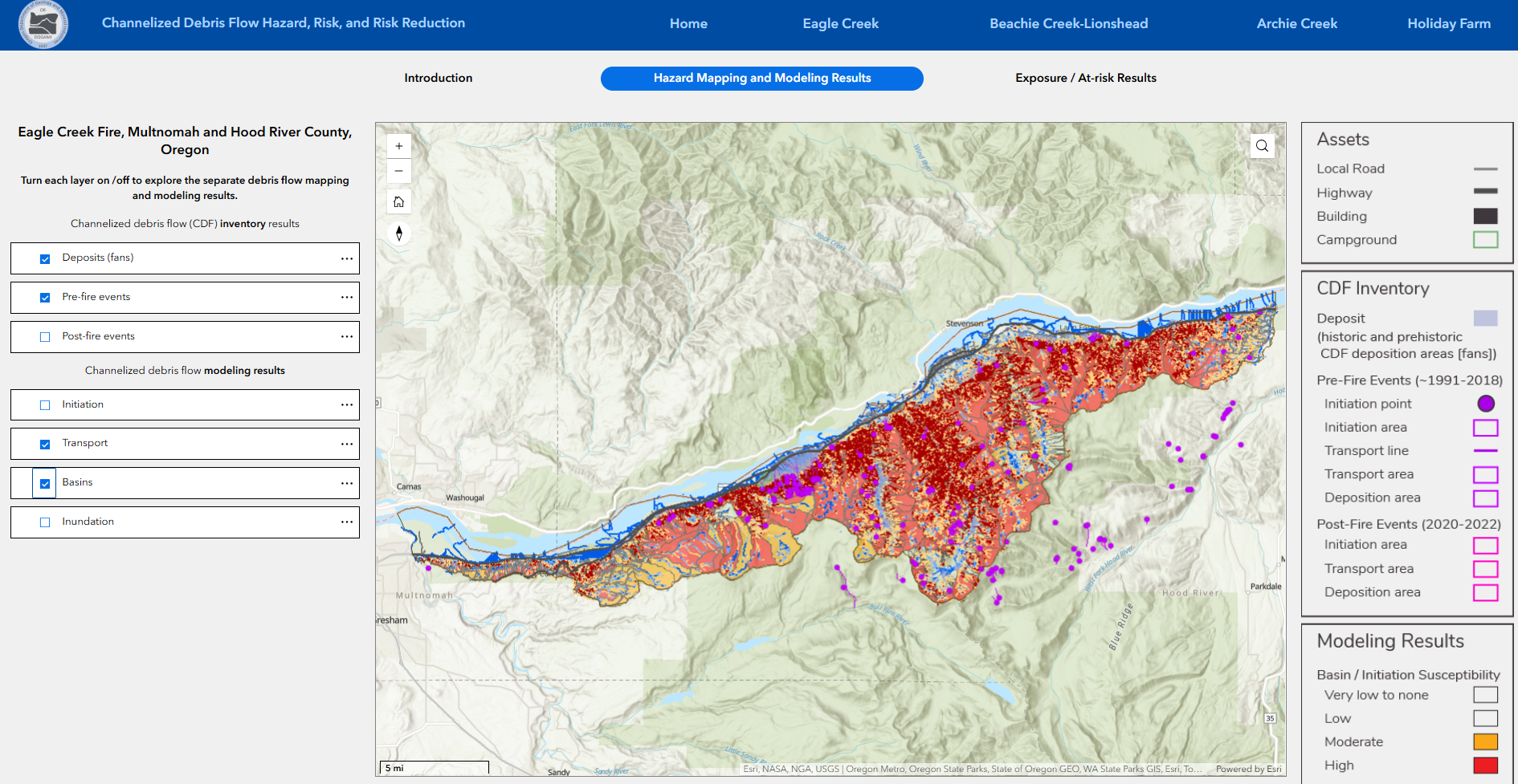
Interactive web maps of historic channelized debris flows and modeled potential future channelized debris flows can be viewed and explored for each of the four study areas
at this link. For example, the below screencap shows the interactive web map of the Eagle Creek fire area showing the location of fan deposits, pre-fire events, modeled transport regions, and modeled depositional basins.
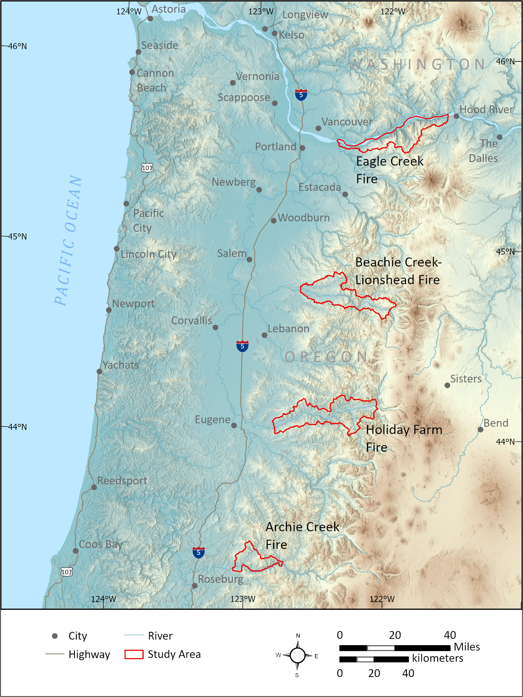
LOCATION MAP
Figure 1-1. Map of the four study areas: Eagle Creek Fire, Beachie Creek-Lionshead Fire, Holiday Farm Fire, and Archie Creek Fire.
EXECUTIVE SUMMARY
Channelized debris flows (CDFs) are one of the most widespread and damaging natural hazards in Oregon. They can destroy buildings and infrastructure and move rapidly, faster than a person can run, and thus pose a threat to life safety. In September 2020, the Labor Day megafires burned a large portion of the debris flow-prone Oregon Cascades and then, only months later in January 2021, a debris flow in the Columbia River Gorge initiating from the area scorched in the 2017 Eagle Creek Fire (termed a postfire debris flow) resulted in a fatality. The combination of the two devastating events encouraged the Oregon Department of Geology and Mineral Industries (DOGAMI) to propose the project described in this report to the Federal Emergency Management Agency (FEMA). Funding for this project was provided by FEMA grant number EMS-2021-CA-00011.
The purpose of this project is to identify areas susceptible to CDFs and postfire CDFs, analyze the potential assets at risk, and develop a road map to risk reduction in collaboration with the communities. To accomplish this purpose, we performed 4 primary tasks:
- Mapping past CDF events and deposits,
- Modeling future CDF susceptibility,
- Risk analysis,
- Development of a roadmap to risk reduction.
The mapping revealed 2,009 CDF deposition areas (fans) and hundreds of historic and prehistoric CDF events within each study region. The modeling resulted in the creation of three inundation zones: Typical, Intermediate, and Extreme. We identified the need to add an additional inundation zone to identify areas of potential avulsion. The results of the inundation and avulsion modeling are displayed in each study region in Appendices A-D and via the online interactive map.
For the risk analysis, we compiled and created datasets that included buildings, permanent population distribution, critical facilities, land use, roads, and campgrounds. The asset dataset results are summarized by communities within each of the four study regions. The primary results of the risk reduction activities include:
- Compiled list of previously published reports and fact sheets with recommendations for risk reduction
- Community meetings
- Roadmaps to risk reduction
Although we cannot predict when and where the next CDF events will occur, we were able to provide detailed maps of areas previously impacted by historic and prehistoric CDFs and model where future CDFs are more and less likely to occur. We conclude that central and eastern portions of the study regions are generally more susceptible to CDFs and postfire CDFs, depending on the exact locations burned. We mapped 1,061 CDFs and 450 postfire CDFs in the study area, which indicates a relatively high CDF hazard.
The overall annualized rate of pre-fire CDFs for all four study regions is approximately 44 CDFs/year with a range from 6–20 CDFs/year for the individual study regions. The overall annualized rate of postfire CDFs for all four study regions is approximately 129 CDFs/year with a range from 25–58 CDFs/year for the individual study regions. These rates may be slightly less than reality because of limitations of mapping with aerial photos in Western Oregon, but the differences in rates are likely more accurate. The main conclusion is the CDF rates go up in areas that have burned.
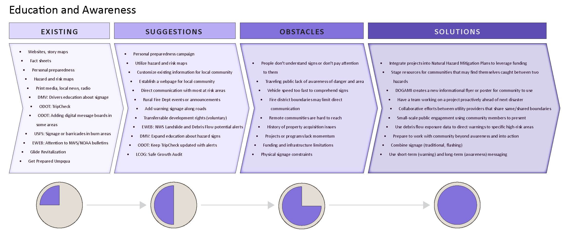
ROADMAPS TO RISK REDUCTION
To support risk reduction in regions vulnerable to channelized debris flows, study authors collaborated with community members from the study areas to develop four roadmaps to risk reduction. These roadmaps incorporate existing methods of risk reduction, suggested ideas for additional risk reduction strategies, obstacles to those ideas, and potential solutions to those obstacles.
Roadmap 1 - Awareness and Education (2.2 MB PDF)
Roadmap 2 - Emergency Preparedness and Warning Systems (1.8 MB PDF)
Roadmap 3 - Planning and Regulation (1.9 MB PDF)
Roadmap 4 - Physical Mitigation (2.0 MB PDF)
FACT SHEETS
Study authors developed fact sheets summarizing debris flow risks following wildfires and for specific risks in each of the four study areas. The first page of the fact sheets is shown below, followed by the site-specific information.
Eagle Creek Fire Fact Sheet (2 p., 45.5 MB PDF)
Beachie Creek and Lionshead Fire Fact Sheet (2 p., 43.5 MB PDF)
Holiday Farm Fire Fact Sheet (2 p., 45.5 MB PDF)
Archie Creek Fire Fact Sheet (2 p., 56.2 MB PDF)
FINAL PROJECT MEETING PRESENTATION
The following video presents the final presentation for this project. The material presented in this video can also be read about in the text report.