FS-17
| 2025
|
Trifold brochure PDF
Fact sheet PDF
Experience Builder website
|
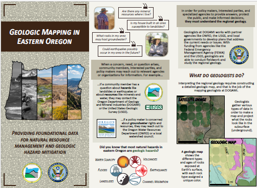
Outreach Materials for Exploring Geologic Mapping in Eastern Oregon, 2025
|
|
FS-16
| 2022 |
PDF |
Cascadia Earthquake Knowledge Points for Emergency Managers and the Public,2022, 9 p. |

|
| FS-15 | 2019 |
PDF |
Hydraulic Fracturing in Oregon,originally released 2015; latest revision 2019, 1 p. |

|
| FS-14 | 2014 | --- |
Base Flood Elevation Determinations, 2014, 2 p.
Note: DOGAMI no longer produces Base Flood Elevation reports. |

|
| FS-13
| 2013 |
PDF |
Tsunami Inundation and Evacuation Maps for Oregon, 2013, 2 p. |

|
| FS-12 | 2012 |
PDF |
Geothermal Exploration & Development in Oregon, 2012, 4 p. |

|
| FS-11 | 2012 |
PDF |
Mount Hood Multi-Hazards Risk Study, 2012, 4 p. |

|
| FS-10 | 2011 |
PDF |
Oregon Lidar Consortium (OLC), 2011, 2 p. |

|
| FS-9 | 2011 |
PDF |
New FEMA Flood Maps for Coos County, Oregon, 2011, 4 p. |

|
| FS-8 | 2010 |
PDF |
Understanding Landslide Deposit Maps, 2010, 2 p. |

|
| FS-7 | 2010 |
PDF |
TsunamiReady™, TsunamiPrepared, Oregon Coast-Wide National Tsunami Hazard Mitigation Program, 2010, 2 p. |

|
| FS-6 | 2009 |
PDF |
FEMA Flood Map Modernization, 2009, 2 p.
Prepared for the 2009 Oregon Legislative Session |

|
| FS-5 | 2014 |
PDF |
Lidar Data Acquisition, Uses, & Partners,
Originally prepared for the 2009 Oregon Legislative Session,
2014 revision, 2 p. |

|
| FS-4 | 2013 |
PDF | Oregon Department of Geology and Mineral Industries,
2013 revision,
2 p. |

|
| FS-3 | 2008 |
PDF
(printer-friendly version) |
Tsunami Hazards in Oregon, 2008,
04-03-2009 revision, 4 p. |

|
| FS-2 | 2007 |
PDF |
LNG - Liquefied Natural Gas -- building & regulation of LNG import facilities, 2007, 2 p. |

|
| FS-1 | 2006 |
PDF |
Landslide Hazards in Oregon, 2006, 2 p. |

|