DOGAMI OPEN-FILE REPORT SERIES
Publication Preview
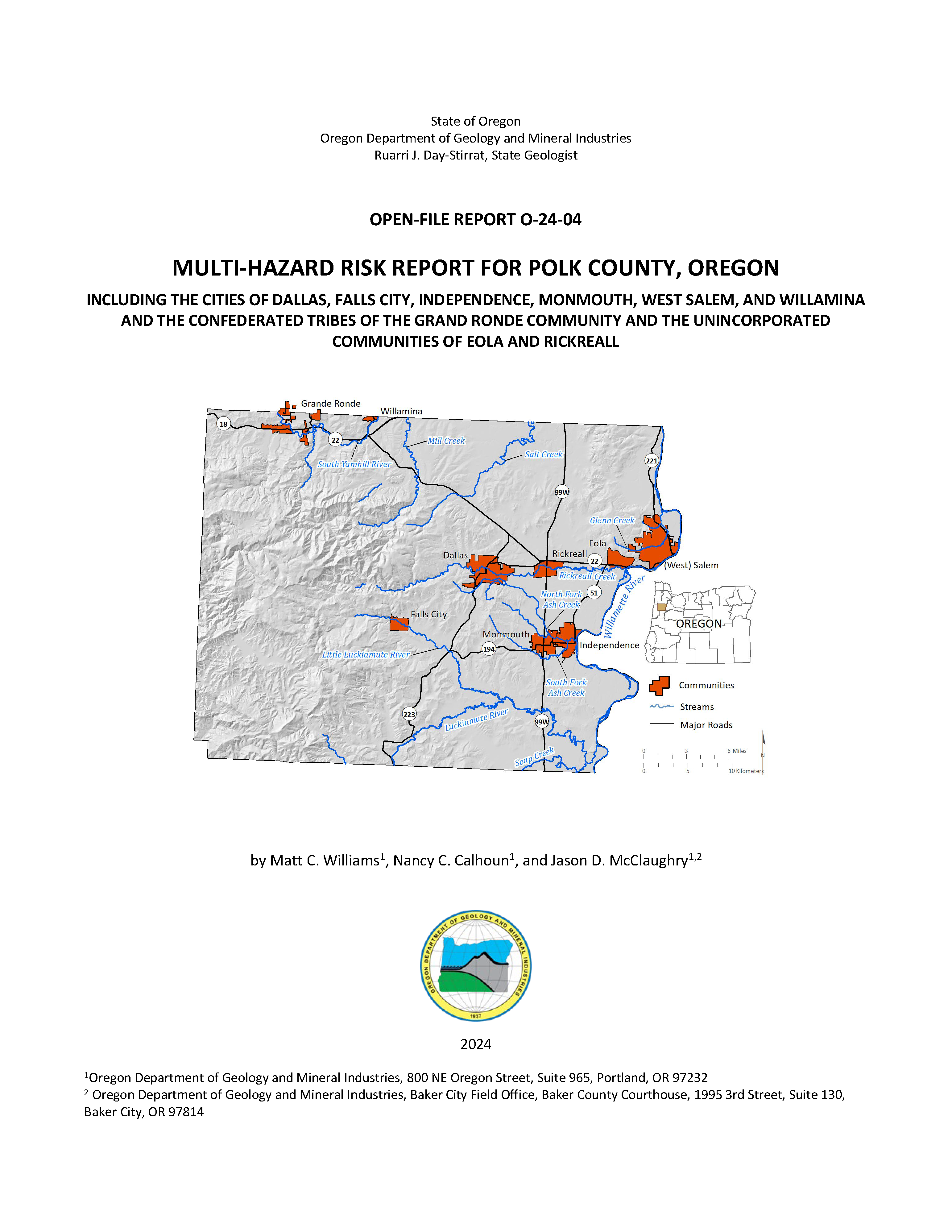
Open-File Report O-24-04, Multi-Hazard Risk Report for Polk County, Oregon, by Matt C. Williams, Nancy C. Calhoun, and Jason D. McClaughry; 94 p. report, 9 tabloid size map plates, two Esri® geodatabases with internal metadata, external metadata in .xml format.
WHAT’S IN THIS REPORT?
This report describes the methods and results of a natural hazard risk assessment for communities in Polk County. The results quantify the impacts of natural hazards to each community and enhance the decision-making process in planning for disaster.
PUBLICATION DOWNLOADS
EXECUTIVE SUMMARY
This report was prepared for the communities of Polk County, Oregon, with funding provided by the Oregon Department of Land Conservation and Development (DLCD). It describes the methods and results of a natural hazard risk assessment performed in 2023 by the Oregon Department of Geology and Mineral Industries (DOGAMI) within Polk County (herein referred to as the study area). The purpose of this project is to provide communities with detailed risk assessment information to enable them to understand and compare hazards and act to reduce their risk. The risk assessment results quantify the consequences of natural hazards to each community and support the decision-making process in planning for disaster.
We arrived at our findings and conclusions by completing three main tasks: compiling an asset database, identifying and using the best available hazard data, and performing a natural hazard risk assessment.
- In the first task, we created a comprehensive asset database for Polk County by synthesizing assessor data, United States (U.S.) Census information, Federal Emergency Management Agency (FEMA) Hazus®-MH general building stock information, and building footprint data. This work resulted in a single dataset of building points and their associated building characteristics (e.g., construction materials, number of floors, usage, etc.). Using these data, we were able to represent accurate spatial locations and vulnerabilities on a building-by-building basis.
- The second task was to identify and use the most current and appropriate hazard datasets for the study area. Most of the hazard datasets used in this report were created by DOGAMI and produced using peer-reviewed methods and with high-resolution, lidar topographic data. Although not all the data sources used in the report provide complete, countywide information, each hazard dataset used was the best available at the time of the analysis. Data sources and coverage are discussed in detail for each hazard in Assessment Overview and Results.
- In the third task, we analyzed risk using Esri® ArcGIS Desktop® software. We took two risk assessment approaches: (1) estimated loss (in dollars) to buildings from floods and earthquakes using the Hazus-MH methodology, and (2) calculated the number of buildings, their value, and associated populations exposed to earthquake, flood, landslides, channel migration, and wildfire hazards. Details on recurrence intervals, susceptibility, hazard levels and other particulars are discussed in detail for each hazard in Assessment Overview and Results.
The findings and conclusions of this report show the potential impacts of hazards to communities within Polk County. A Cascadia subduction zone (CSZ) earthquake is expected to cause significant damage and losses (10%) throughout the county. Our findings indicate that most of the study area’s critical facilities are at high risk during a CSZ earthquake. A modeled Mw 6.6 earthquake on the Turner and Mill Creek fault system is expected to cause moderate damage for heavily populated areas in the eastern portion of Polk County. We exhibit the potential for the reduction in damages and losses from seismic retrofits through building code simulations in the Hazus-MH earthquake model. Flooding is identified as a very high-risk hazard event for some communities in the county (e.g., Grand Ronde, West Salem, and Independence) and we quantify the number of elevated structures that are less vulnerable to flood hazard. Our analysis shows that areas with moderate to steep slopes or at the base of steep hillsides are at greatest risk to landslide hazards, which are present in areas near West Salem and throughout the central portion of the county. We also found that the hazards with the highest potential of population displacement are landslide hazards with more than 12,000 people residing on high or very high susceptible landslide zones. Our wildfire exposure analysis shows a higher risk for buildings within the wildland-urban interface (WUI) portions of the county and in the forested central portions of the county.
The information presented in this report is designed to increase awareness of natural hazard risk, to support public outreach efforts, and to aid local decision-makers in developing comprehensive plans and natural hazard mitigation plans. This study can help emergency managers identify vulnerable critical facilities and develop contingencies in their response plans. The results of this study are designed to be used to help communities identify and prioritize mitigation actions that will improve community resilience.
Results were broken out for the following geographic areas:
- Unincorporated Polk County (rural)
- Community of Eola
- Community of Rickreall
- City of Dallas
- CIty of Falls City
- Confederated Tribes of the Grand Ronde Community**
- City of Independence
- City of Monmouth
- City of West Salem*
- City of Willamina
*Only the part of the city of Salem within Polk County was examined in this report. This portion is referred to as West Salem throughout the report. See O-22-05 (Williams and Madin, 2022) for a multi-hazard risk assessment for the entire city of Salem.
**The Confederated Tribes of the Grand Ronde Community is referred to as “Grand Ronde” in this report.
Selected Countywide Results
Total buildings : 42,552
Total estimated building value: $13 billion
|
Cascadia Subduction Zone
Magnitude-9.0 Earthquake
Red-tagged buildingsa : 1,111
Yellow-tagged buildingsb : 4,404
Loss estimate: $1.3 billion
| Turner and Mill Creek faults
Magnitude-6.6 Earthquake Scenario
Red-tagged buildingsa : 626
Yellow-tagged buildingsb : 2,258
Loss estimate: $726 million
|
100-year Flood Scenario
Number of buildings exposed: 592
Exposed building value: $35 million
| Landslide Exposure (High and Very High Susceptibility)
Number of buildings exposed: 8,004
Exposed building value: $1.9 billion
|
Wildfire (High and Moderate Risk):
Number of buildings exposed: 907
Exposed building value: $192 million
|
|
aRed-tagged buildings are considered uninhabitable due to complete damage
bYellow-tagged buildings are considered limited habitability due to extensive damage
|
GEOGRAPHIC INFORMATION SYSTEM (GIS) DATA
Geodatabase is ESRI® version 10.7 format. Metadata are embedded in the geodatabase and are also provided as separate .xml format files.
Polk_County_Risk_Report_Data.gdb |
Feature dataset: Asset_Data
|
|
Building_Footprints |
polygons | .xml
|
Communities |
polygons
| .xml
|
UDF_points
| points | .xml
|
| Polk_County_Depth_Grids.gdb |
| FL_Depth_10 | polygons | .xml
|
| FL_Depth_50 | polygons
| .xml
|
FL_Depth_100
| polygons | .xml
|
FL_Depth_500
| polygons
| .xml
|
APPENDIX E: MAP PLATES (PDFs, 17x11 inches each)