The Oregon Department of Transportation is working to improve the overall safety and mobility of US 97. Learn about the project and provide your input in this interactive online open house.
Below you will find topic-specific comment forms to provide your feedback on the following four topics below. Please feel free to respond to topics that interest you. Alternatively, you may select the general comments form for broader project input.
Why the Project is Needed
US 97 is the main north-south transportation corridor through Central Oregon and a critical part of the state’s transportation system. Demand continues to increase along US 97, with average traffic rates of over 12,000 vehicles per day.
Safety is a concern due to limited passing opportunities, leading to lengthy following times that sometimes result in drivers making passing maneuvers with high speeds and limited sight distances.
This section of highway also has a high frequency of animal/vehicle collisions, with over 150 reported deer/elk collisions occurring in the past five years.
This project aims to improve the overall safety and mobility for the freight industry, local commuters, and recreationists by expanding US97 to create a four-lane divided highway. The proposed six-mile project is located within the Deschutes National Forest and plans to include aesthetics associated with the Forest Plan-designated Scenic View corridor.
The proposed wider, forested median reduces the need for a continuous raised median barrier and allows for views from the highway and toward the highway to be compatible with the surrounding forest. It will tie into approximately 15 miles of recently constructed highway improvements north of this proposed project creating a more cohesive transportation system along the US 97 corridor.
Open House Topics
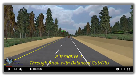
This project proposes three alternatives for US 97 at "the knoll," a topographic high point located near milepost 156. The three options are presented in the video and by the images below.
As you review the video and images, keep in mind the following project goals:
- Reduce wildlife collisions and promote continued use of historic wildlife migration routes.
- Include aesthetics associated with the Forest Plan-designated Scenic View corridor.
Aerial images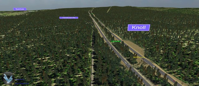 US 97 NB through the knoll
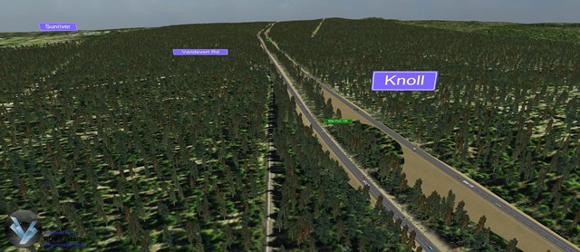 US 97 NB over the knoll
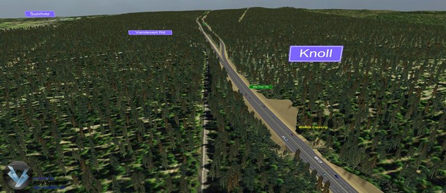 US 97 NB around the knoll
| Through the knoll (K1) |
Divided highway with northbound lanes through the knoll; balanced cut/fill at knoll. |
Vegetated median; compliant with the scenic view component of the Forest Plan. Allows for wildlife undercrossing at milepost 156. The majority of the new alignment can be built outside of the existing travel lanes, reducing delays to the traveling public during construction. |
|---|
| Over the knoll (K2) |
Divided highway with northbound lanes up and over the knoll. |
Vegetated median; compliant with the scenic viewcomponent of the Forest Plan. The majority of the new alignment can be built independent of the existing highway, reducing delays to the traveling public during construction. |
|---|
| Around the knoll (K3) |
Balanced cut/fill; brings divided highway together at knoll with barrier separation. |
Smaller footprint resulting in less loss of wildlife habitat. Allows for wildlife undercrossing at milepost 156. Balanced cut/fill design requires less soil to be hauled in or off the project site. |
|---|
This project proposes to construct wildlife crossings within the project area on US 97. Wildlife undercrossings are being considered near milepost 154 and milepost 156, and either a wildlife overcrossing or undercrossing is proposed to be constructed at milepost 157. The video and images below highlight the wildlife crossing alternatives at milepost 157.
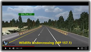 This video simulation starts on the south end of the proposed project, at milepost 159, near the County Transfer Station access. Along the six-mile alignment, the simulation points out three proposed wildlife undercrossing at milepost 154.4, 156.2, and 157.2. At milepost 157.2, a possible overcrossing is also being evaluated as part of the project scope.
Aerial images
 Wildlife overcrossing option at MP 157
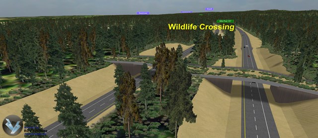
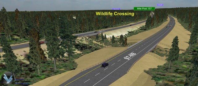 Wildlife undercrossing option at MP 157
| Wildlife overcrossing |
Vegetated wildlife crossing over US 97 at milpost 157. |
Increased habitat connectivity, wildlife mobility and reduced wildlife/vehicle conflicts. Most animals, including elk and deer, prefer wildlife overcrossings because they are more open by design. |
|---|
| Wildlife undercrossing |
Vegetated wildlife crossing under US 97 at milepost 157. |
Increased habitat connectivity, wildlife mobility and reduced wildlife/vehicle conflicts. |
|---|
This project proposes improvements to the intersection of US 97 and Vandevert Road to improve safety and traffic mobility. In the last five years, there were 10 crashes reported at this intersection, nine resulted in injuries. These incidents were recorded as “angle movement” crashes, commonly caused by “crossing conflicts” at this location, which historically results in higher severity injuries.
Existing conditions and two alternative improvements are highlighted in the video and images below:
Aerial Images
US 97 and Vandevert Road existing intersection
US 97 and Vandevert Road - Option V1A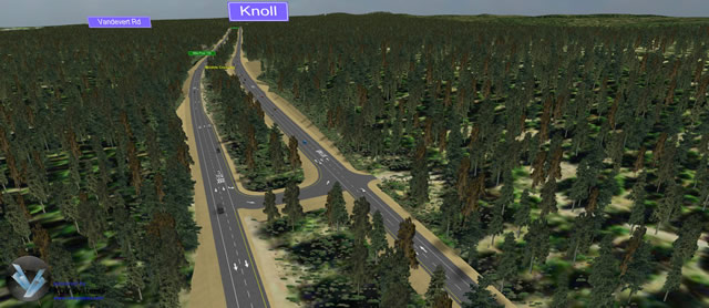
US 97 and Vandevert Road - Option V2
| Existing (no build) |
Existing |
All turning movements maintained; no out of direction travel. |
|---|
| Option V1A |
Vandevert to Bend left turn |
This alternative reduces conflict points by 56% compared to existing conditions. No out of direction travel for the higher volume moves (Vandevert north to Bend and Bend south to Vandevert). |
|---|
| Option V2 |
South median u-turn with northbound acceleration lane |
This alternative reduces conflict points by 50% compared to existing conditions and reduces crossing conflicts, which typically result in higher severity crashes, by 88%. This alternative also accommodates all existing turning movements with some out of direction travel. |
|---|