The Oregon Coast
The Oregon coast is about 560 km (360 miles) long with long stretches of sandy beaches bounded by resistant headlands. These types of systems are referred to as "littoral cells" and include both a cross-shore and a longshore extent. There are at least 18 major littoral cells on the Oregon coast, with the majority of the shoreline (72%) consisting of either dune- or bluff-backed sandy beaches, while the remaining 28% of shore is a mixture of rocky shores, mixed sand and gravel beaches, and coarse grained (gravel) beaches. Most beaches of Oregon are backed by sea cliffs that have eroded into Tertiary mudstones and siltstones, in places capped by Pleistocene terrace sands (million-year old uplifted beaches and dunes), while along low-lying stretches of coast the beaches are backed by modern active sand dunes or are part of barrier spits that have developed across estuaries and bays.
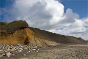
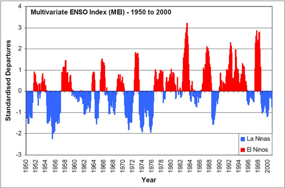
Dunes backing Rockaway Beach, OR (left), Bluffs backing Beverly Beach, OR (middle), Headlands of Cape Meares (right)
An Evolving Coast
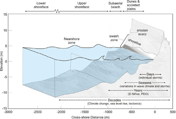
Coasts are some of the most dynamic and changeable of all landforms, responding to a myriad of complex variables that reflect the interaction of processes that drive coastal change (waves, currents, and tides), and the underlying geological and geomorphological characteristics of the beaches (sediment grain size, shoreline orientation, beach width, sand supply and losses, etc.). They exhibit long-term evolutions oferosionandaccretionon the order of decades and millennia, but are also strongly influenced by large storms which can dramatically change the coast in a matter of hours.
How Does Coastal Change Occur?
One of the primary ways that coastlines evolve is through the processes of erosion and accretion. Erosion is the wearing away of land and removal of beach sediment by wave and wind forces. Sediment eroded from one area is typically redistributed in another through the form of accretion, the process of sediment building up a beach. Because coastlines can be largely populated areas, changes occurring to the landform can have a large impact on infrastructure, communities and ecosystems. Check out the coastal hazards link to learn more about these types of hazards, the processes that cause them and mitigation approaches.
Dune-Backed Shores
An impressive stretch of sanddunesoccur along the Oregon coast. Born by sediments distributed by waves and carried inland from the beaches by wind, an estimated 45 percent of the Oregon coast is backed by sand dunes.
How Do Dunes Form?
The three ingredients necessary for dune formation are: loose sand, wind and plants. Small sand granules are picked up from the beaches and carried inland until they are captured by vegetation, which slows the winds enough to cause them to release and deposit the sand particles. In fact, were it not for the Oregon's dense coastal forests, sand would be carried inland all the way to the base of the Coast Range.
Varying Dune Morphologies
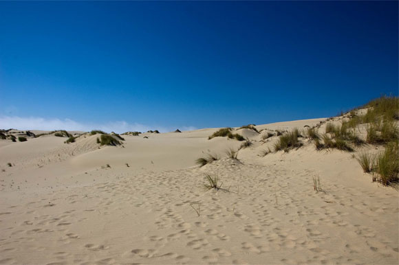
Coos Bay dune sheet - Stretching nearly 97 meters (60 miles) on the central/Southern Oregon coast from Coos Bay to Heceta Head, an expansive unit of continuous dunes known as the "Coos Bay dune sheet" is the largest dune field in the United States. Bounded by ocean and forest this extensive feature creates a desert –like landscape with wind-sculpted dunes that are often times over 46 meters (150 feet) tall. Unlike much of the Oregon coast which is backed by steep headlands, this stretch of the Oregon shoreline has gently sloping coastal bedrock of marine sandstone, allowing the sand to drift inland by as much as 4 kilometers (2.5 miles).
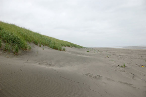
Clatsop Plains - A much narrower and more heavily vegetated band of dunes are those in the Clatsop Plains region. Although most of the sediment from the Columbia River flows northward into Washington, some of the sand is diverted to Oregon beaches, forming Clatsop Plains just south of the Columbia River inlet. Extending for 32 kilometers (20 miles) to Tillamook Head, this continuously growing feature (due to the Columbia River jetty) has some dune crests that reach 14 meters (45 feet).
Influence of Humans
Structures such as jetties have had a large influence on dune geomorphology. For example, construction of the Columbia River jetty increased the water velocity from the estuary, scouring out massive amounts of sand from the inlet and pushing it offshore. This sediment has slowly been making its way back to the coast just north and south of the river, creating the effect of very large dunes and wide beaches.
Introduction of European (Ammophila arenaria) and American (Ammophila breviligulata)beach grasses in the early 1930s also dramatically changed this dune morphology as well as the local ecology. Initially used for stabilization, these grasses quickly spread throughout the coastlines of Washington, Oregon and California. Areas dominated by European beach grasses are much more successful at capturing blowing sand, causing the dunes to build upward resulting in tall, narrow dunes that are fixed close to the shore. American dune grasses create shorter, wider dunes.
Bluff-Backed Shores
Sea cliffs (also called bluffs) are characteristic of much of the Oregon coast. Typically, a cliff is composed of a base of Tertiary mudstone and siltstone deposits, which originated on the deep ocean floors. Pleistocene terrace sandstone from ancient dunes and beaches was then overlain, forming the cap of the bluffs. Subduction of the Juan de Fuca plate has uplifted these layers where they are continuously eroded by the wind and water.
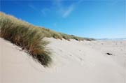
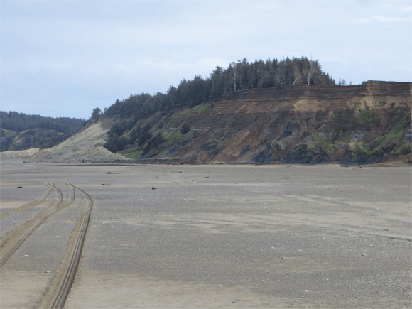 Uplifted marine terrace near the Elk River Spit, OR
The ENSO Effect
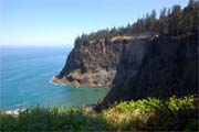
Recently, it has been recognized that the occurrence of severe storm events and associated "hot spot" erosion are related to major climate regime shifts such as the El Niño/La Niña Southern Oscillation (ENSO) phenomenon. El Niños occur roughly every 5 to 6 years but may recur on 2 to 7 year cycles. During an El Niño, the ocean sea level along the Oregon coast is typically raised by tens of centimeters along the Oregon coast. As a result, waves superimposed on the tides are able to reach much higher elevations on beaches and bluffs , contributing to much higher rates of coastal erosion. Furthermore, because the storm tracks are shifted further south so they mainly cross the California coast, wave approach offshore of the coast is increasingly from the southwest, contributing to "hot spot" erosion along the southern ends of the littoral cells, northern ends of river mouths, and tidal inlets to the bays, with a net drift of beach sands to the north. Less well known is the coastal response associated with a La Niña, largely because of the relatively few La Niñas that have occurred over the past 40 years. During this climate phenomenon, mean water levels tend to be much closer to normal, while large winter storm systems cross the PNW coast. As a result of the storm tracks, wave energy levels tend to be elevated during La Niña events and coastal erosion may increase.