Closed Mining Permit Viewer (closed prior to 2016)
 The Closed Mining Permit Viewer interactive map shows mine site locations and information, including downloadable permit files. The permit data and files available were compiled from the hard copy permit held by the Oregon Department of Geology and Mineral Industries (DOGAMI) Mineral Land Regulation and Reclamation (MLRR) program.
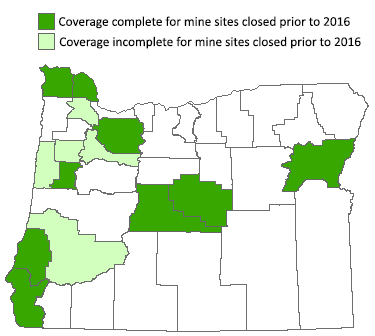
*Please note that the information currently available through the Mining Permit Viewer is for surface mine sites that were closed prior to 2016. The Mining Permit Viewer does not have information regarding currently open mine sites.
Coverage
Currently the map shows permit data for the following counties. Data for other counties will be added as resources allow.
Baker
Benton
Clackamas
Clatsop
Columbia
Douglas (incomplete)
Lincoln (incomplete)
Marion (incomplete)
Polk (incomplete)
Washington (incomplete)
Types of Permit & Data Files
The information contained in the PDF downloads has been collected over the life of the mine site beginning as early as July 1, 1972 and ending with the latest data. Each mine site may have many records available for download. Please note: Files that exist only in the electronic version of the permit are not available for download. Data have not been reviewed for completeness or accuracy.
There are three types of records; the suffix in the document title and the description help identify what files are available.
Mining Files
"LS" - "Left Side - Permits and Inspection" -
These records are from the left side of the physical mining file and contain information regarding issued permits and inspections.
"RS" - "Right Side - Permit Info and Communications" -
These records are from the right side of the physical mining file and contain information regarding the permit; such as the site plan, reclamation plan, and coordination between DOGAMI and the permittee or other agencies.
Water Quality Files
"WQLS" - "Left Side - Permits, Inspections, Renewals, Compliance" -
These records are from the left side of the physical water quality file and contain information regarding the permit, inspections, renewals, and compliance.
"WQRS" - "Right Side - Applications, Monitoring, Plans, Correspondence" -
These records are from the right side of the physical water quality file and contain information regarding the application, monitoring plans, and correspondence.
Large Format Maps
"M__" -
These records are large format maps from the file; they may include site plan information, permit boundaries, topographic features, etc.
Permit Codes & Explanation
Mining Permit and Status Code Reference:
Excel |
PDF
Getting started
The map is hosted on Esri® ArcGIS.com® The map link takes you to that site.
To view mining permit documents:
- Open the map.
- Click on a mine site.
- In the popup window that appears, note the Document Description (see list record types above) and click on the Document PDF link to view the PDF.
- Note that a mine site may have several documents. Look at the top of the popup window to see how many documents are available. Click on the arrow to advance to the next document type.
Show me (video).
For more information on understanding the map, see the
Help page.
Map viewer history
- 08/02/2016 site deployed.
(last updated 05/13/2022)