
Oregon State Flag An official website of the State of Oregon »

OR 229 Landslide Closure and Rebuild

OR229 slide aerial

Contacts

Jim Doll
Transportation Project Manager
📞 541-286-8358
james.p.doll@odot.oregon.gov 


Mindy McCartt

Public Information Officer
📞 503-507-6045
mindy.m.mccartt@odot.oregon.gov


Highway 229

OR 229 remains closed after a major landslide destroyed a section of the highway between mileposts 14.2 and 15.1 in December 2025.

ODOT is beginning the next phase of work responding to the landslide. In the coming weeks, nearby residents may see heavy equipment working in and around the slide area as crews prepare for subsurface investigations.

This is an important milestone and a critical step toward designing the highway repair. The information gathered over the coming months will guide the design of both temporary and permanent repair options.

Much of the work is happening underground and behind the scenes, but it will provide engineers with the information needed to design a safe, long-term repair.

There is currently no estimated schedule for reopening OR 229. ODOT expects to have further information to share this fall.

View photos of the landslide and response efforts in our OR 229 Landslide Flickr album. We'll add new images as work continues. 


On Dec. 12, 2025, a large landslide occurred on OR 229 (Siletz Highway) at milepost 14.

Initial movement was reported around 3 a.m., followed by full slope failure between 4 and 5 a.m.

The landslide impacted approximately 1,000 feet of highway. It originated at least 200 feet above the road on private property before moving downslope and destroying the roadway.​

ODOT is now focused on collecting information below the surface to better understand the landslide and guide future repair designs.

A geophysical survey near the bottom of the landslide began in July. This non-invasive method maps underground soil and rock layers without excavation. The information gathered will help guide drilling teams and refine where additional subsurface exploration is needed. Field work is expected to be completed in August.

Crews are also creating temporary access paths so drilling equipment can safely reach investigation sites. Heavy equipment will be used to move fallen trees and grade rough paths while minimizing disturbance to the landslide.

Geotechnical drilling is expected to begin in mid-August and continue through the end of October. During drilling, engineers will collect soil and rock samples and install monitoring equipment in each drill hole.

After drilling is complete, ODOT will continue monitoring the sites to better understand how the landslide moves over time and how groundwater affects slope stability, especially during the winter months.

Most of the drilling work will occur outside the existing highway right of way with permission from adjacent property owners.

Why is this work necessary?

Before engineers can design a safe repair, they need a better understanding of what is happening below the surface.

The subsurface investigations will help engineers:

  • Map underground soil and rock layers.
  • Determine how deep the landslide extends.
  • Measure groundwater levels.
  • Monitor ongoing ground movement.
  • Design long-term highway repairs and slope stabilization measures.

Temporary access road and highway repairs

ODOT remains committed to restoring access as safely and quickly as possible.

Initial investigations identified areas of continued wet soil and unstable slopes within the landslide that require additional subsurface exploration before engineers can safely design a temporary access road or permanent highway repair.

The information collected over the coming months will help ODOT develop repair concepts, estimate costs and establish future construction timelines.

There is currently no estimated schedule for reopening OR 229, but ODOT expects to have further information to share this fall.
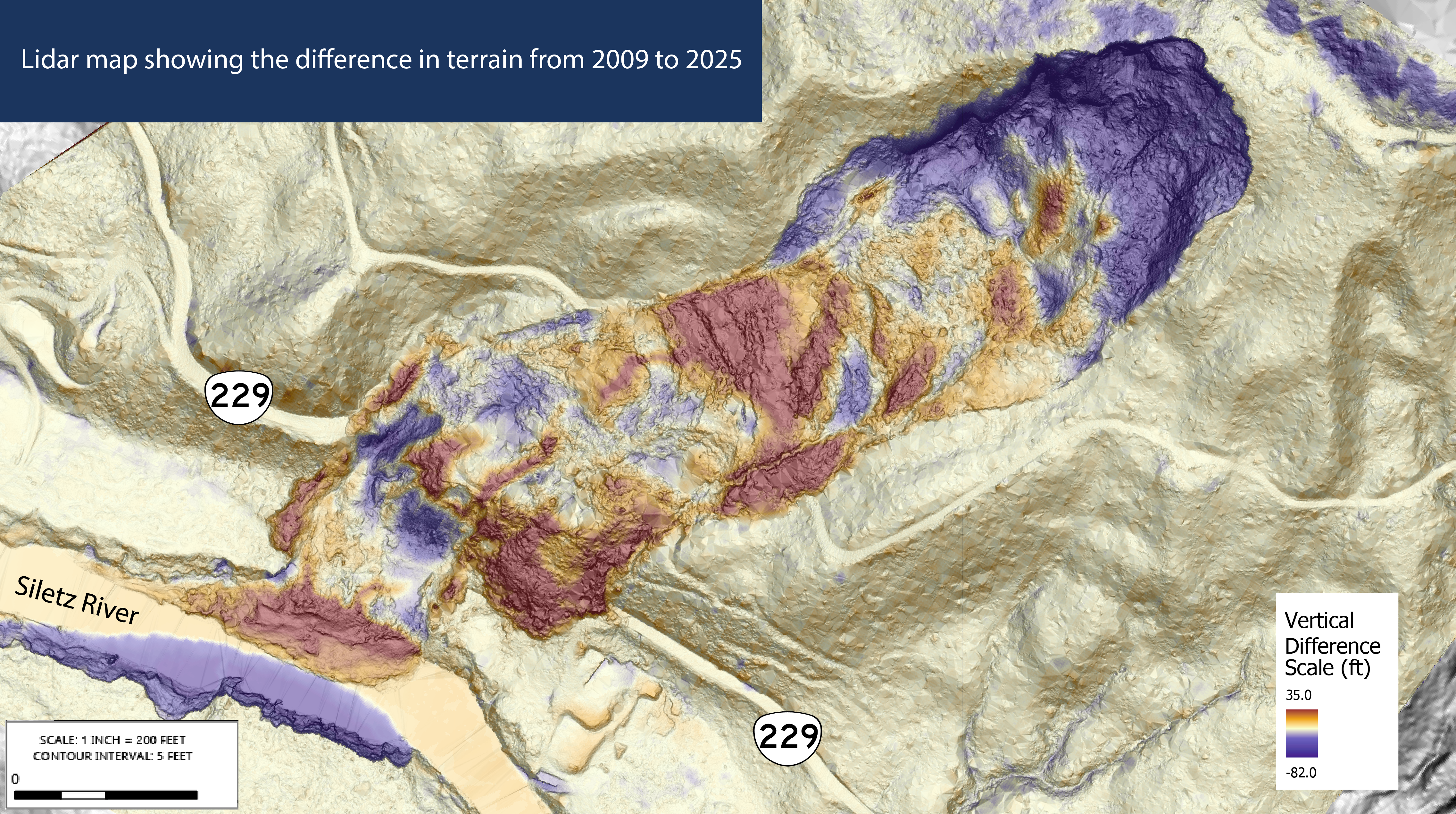


Lidar map of the OR 229 slide area

Lidar is a technology that uses laser pulses to measure distances and create detailed 3D maps of the ground and objects.

Rebuilding OR 229 is a complex process. Before traffic can fully return, work will include:

  • Completing detailed surface and subsurface investigations.
  • Understanding the depth and movement of the landslide.
  • Monitoring groundwater and slope conditions.
  • Developing measures to stabilize the slope.
  • Designing drainage to manage groundwater and surface water.
  • Developing temporary and permanent repair options.
  • Completing environmental review and permitting.
  • Identifying and securing funding for the permanent rebuild.
  • Reconstructing the damaged highway.

The subsurface work underway now will provide critical information needed before repair alternatives can be designed and construction schedules developed.​


There is currently no local detour. We have developed a long-term detour plan and are evaluating potential short-term solutions.

Travelers should plan for longer travel times and use caution on alternate routes. 

Detour map showing traffic using U.S. 20 and U.S. 101 to get around the OR 229 closure​​​​

The Governor declared a state of emergency on Dec. 30, 2025. This allowed us to request Emergency Relief funding from the Federal Highway Administration, which was approved on Feb. 4, 2026. 

ODOT is tracking costs associated with the emergency response and ongoing investigation. Because the state declared an emergency following the landslide, eligible work is expected to qualify for reimbursement through the Federal Highway Administration's Emergency Relief Program.

A cost estimate for the permanent highway repair has not yet been determined. Additional engineering and subsurface investigations are needed before repair alternatives can be designed and construction costs estimated.​

ODOT is monitoring the landslide to better understand slope movement, groundwater levels and conditions below the surface.

During geotechnical drilling, monitoring equipment will be installed in the drill holes. After drilling is complete, ODOT will continue monitoring these locations to track movement within the landslide and changes in groundwater levels.

Groundwater is an important factor because continued wet soil can contribute to slope instability. Monitoring through changing weather conditions, especially during the winter months, will help engineers better understand how the landslide behaves over time.

ODOT is also working with the Oregon Department of Geology and Mineral Industries and Oregon State University. Oregon State University is supporting monitoring efforts through an existing research partnership with ODOT.

Monitoring helps engineers understand slope behavior over time. It does not mean the area is stable or safe for public access.​


Oregon's landscape includes steep terrain, layered soils and heavy seasonal rainfall. These natural conditions increase the risk of landslides along highways, particularly in western parts of the state. 

We continually assess and track unstable slopes statewide. We currently have more than 4,100 identified unstable slopes along Oregon highways, affecting about 7% of the state highway system, or roughly 495 miles of road. 

These include approximately: 

  • 70 debris flows 
  • 2,200 landslides 
  • 1,800 rockfalls 

We prioritize sites based on risk. Currently: 

  • 26 are classified as Critical State 
  • 120 as Immediate Need 
  • 774 as High Priority 
  • Additional sites are categorized as medium or low priority 

All unstable slopes present some level of risk. 

Climate change and earthquakes can increase the likelihood of slope movement. Our focus is on monitoring conditions, responding when needed and keeping roads as safe and reliable as possible for travelers. 

Learn more about how we identify and manage unstable slopes statewide on our Unstoppable Slopes, Landslides, Debris Flows, and Rockfalls webpage. ​