Channel Migration
The Oregon Department of Geology and Mineral Industries (DOGAMI) maps historic stream channels to determine future channel migration hazards.
Channel migration is the natural process by which streams move laterally over time. This process includes bed and bank erosion, sediment deposition, and channel avulsion, an event in which the stream abruptly moves to an entirely new location on the floodplain.
Channel migration can occur gradually across thousands of years or rapidly, usually associated with flood events. It can undermine buildings, roads, levees, and other infrastructure. It can erode land, redirect flooding to new areas, cut off evacuation routes during floods, and, in rare cases, endanger lives. The process of channel migration is not considered in FEMA Flood Insurance Studies and, as a result, channel migration may impact homes outside of the 1%-annual-chance flood zone.
To interact with DOGAMI channel migration zone (CMZ) maps, please see links to individual publications at the bottom of this page or review the
Channel Migration Zone Storymap.
Channel Migration Zones
Channel migration zone (CMZ) maps define the area in which a given stream is likely to move laterally and change its channel course within a defined period of time. The components that comprise DOGAMI CMZ maps are the active channel (AC); historical migration area (HMA); 30-year high, 30-year medium, and 100-year low erosion hazard areas (EHAs); avulsion hazard area (AHA); and flagged streambanks. The method primarily based on the interpretation of historical aerial photographs, high-resolution lidar topography, geologic maps, and flood inundation maps.
CMZ maps are designed to aid in community planning, raise awareness of riverine flood and erosional hazards, and to inform decisions about environmental and emergency management and land use. The maps may be used to identify which buildings, critical facilities, transportation infrastructure, and utility lines are potentially at risk from channel migration and to prioritize areas for pre-disaster risk reduction. These hazard maps provide a valuable resource for Tribal, county, and community planning efforts, including during the development of emergency plans and updates to Natural Hazard Mitigation Plans (NHMPs). DOGAMI often partners with the Oregon Department of Land Conservation and Development to identify strategies that communities can use to reduce risk.
Please note that the maps in these studies do not replace a site-specific analysis by a land surveyor, geologist, engineer, or some combination thereof.
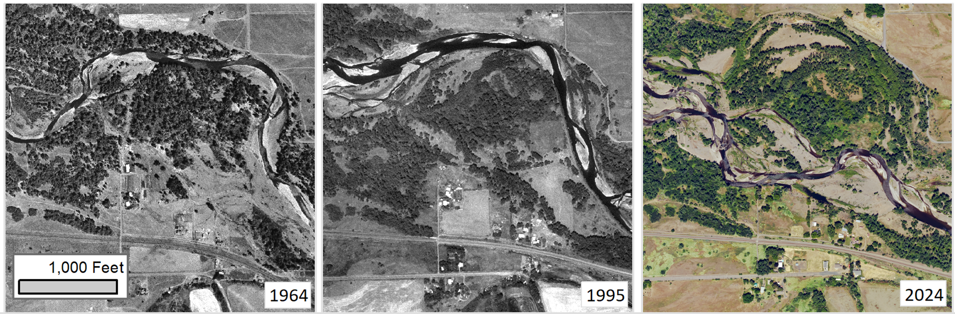 An example of channel migration from 1964 (U.S. Geological Survey, 1964), 1995 (U.S. Department of Agriculture, 1995), and 2024 (Oregon Geospatial Enterprise Office, 2025) along the Umatilla River near Mission, upstream of Pendleton, in Umatilla County, Oregon.
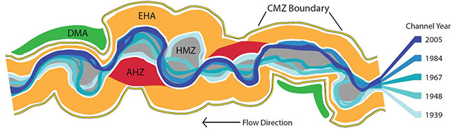
Schematic of channel migration zone and its components.
Historic Channels
Lidar reveals historic channel patterns in ways never before possible. We have created a series of landscape maps to highlight the evolution of channel configurations in the Willamette Valley and beyond.
 Portion of the
Willamette River Historical Stream Channels, Oregon, poster showing historic channels near Albany in the central Willamette Valley..
Portion of the
Willamette River Historical Stream Channels, Oregon, poster showing historic channels near Albany in the central Willamette Valley..
In-Progress and Future Channel Migration Zone Mapping Projects
- Coast Fork Willamette River and tributaries in Lane County
- Rogue River, Little Butte Creek, and Bear Creek in Jackson County
- Yamhill River in Yamhill County
Completed Channel Migration Zone Maps
Lidar Landscapes
Contact DOGAMI
For questions or comments regarding channel migration zone mapping or related topics, contact DOGAMI geologist Christina Appleby by mail, email, or telephone.
Address:
Portland Administrative Office
800 NE Oregon Street, Suite 965
Portland, OR 97232
Email: christina.appleby at dogami.oregon.gov
Phone: 503-505-3284