Florence Project (Last DOGAMI Inundation Map Using the 1997 Approach)
The tsunami inundation map of Florence (DOGAMI IMS-25) is an example of the tsunami hazard mapping approach developed by DOGAMI in 1997 (see DOGAMI Open-File Report O-97-34 for a complete explanation and
Probabilistic tsunami hazard assessment at Seaside, Oregon, for near- and far-field seismic sources [JGR, v. 114, C11023, doi:10.1029/2008JC005132, 2009]). Three Cascadia subduction zone earthquake sources are used to define extreme (~Mw 8.6-8.7), high (~Mw 9), and moderate (~Mw 9+) inundation boundaries:
Vertical deformations caused by the three earthquake sources are illustrated below:
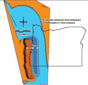
Vertical earthquake deformation for tsunami source used to map the extreme hazard zone (Source 2Cs).
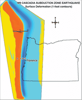
Vertical earthquake deformation for tsunami source used to map the high hazard zone (Source 1A). The uplift offshore for this source is roughly twice that of the 2Cs source.
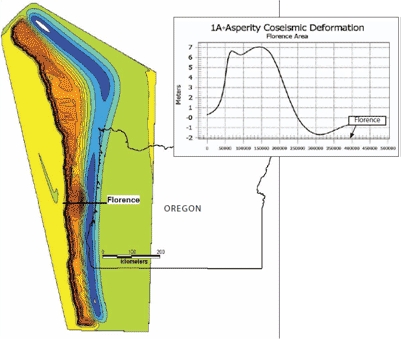
Vertical earthquake deformation for tsunami source used to map the moderate hazard zone (Source 1A-Asperity). The uplift offshore for this source is roughly twice that of the 1A source. A Gaussian-shaped “asperity” is added to the 1A source to simulate an area of unusual uplift analogous to the Prince William Sound (Alaska) Earthquake of 1964.
The 1997 approach was used to produce inundation maps for Gold Beach, Florence, Coos Bay, Alsea Bay, Yaquina Bay, Seaside-Gearhart, and Warrenton-Astoria. The approach has been abandoned in favor of a new technology that maps many more possible tsunamis from the Cascadia subduction zone (see the
Cannon Beach and
Bradley Lake projects). The new approach also simulates two maximum considered tsunamis from the most dangerous distant source, the subduction zone in the Gulf of Alaska.