We cannot prevent a tsunami but we can prepare for one.
Oregon’s Tsunami Hazard Mitigation Program (THMP)
People who live along or visit the Oregon coast critically need accurate educational materials and effective mitigation tools to prepare for the next great Cascadia earthquake and tsunami. The Oregon Department of Geology and Mineral Industries (DOGAMI) has requested over $3 million in funding from the
National Tsunami Hazards Mitigation Program (NTHMP) to complete the next generation of tsunami inundation maps along the state’s 362-mile-long Pacific coastline. The primary goal of Oregon’s five-year plan (2009 to 2013) is to reduce loss of life and property damage from tsunamis. Two other components of Oregon’s tsunami program involve the development of mitigation products that promote community preparedness, and the implementation of a coast-wide, volunteer-driven education and outreach initiative to support the National Weather Service’s
TsunamiReady™ program.
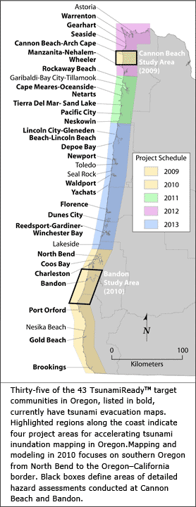
Thirty-five of the 43 TsunamiReady™ target communities in Oregon [see image below;
click for larger image], currently have tsunami evacuation maps. Highlighted regions along the coast indicate four project areas for accelerating tsunami inundation mapping in Oregon. Mapping and modeling in 2010 focuses on southern Oregon from North Bend to the Oregon–California border. Black boxes define areas of detailed hazard assessments conducted at Cannon Beach and Bandon.
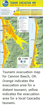
 In the wake of the 2004 Indian Ocean tsunami, DOGAMI advanced the priority to reexamine tsunami hazards for the entire length of the Oregon coast. Reports of tsunami runup as high as 30 to 35 m near the epicenter of the great Sumatra-Andaman Islands earthquake of 2004 raised the question: could the Cascadia subduction zone produce a wave as large as the devastating Indian Ocean tsunami? The urgency for this reassessment is underscored by the results of a recent study of Oregon’s tsunami vulnerability (Wood, 2007), which indicates that the Oregon tsunami-inundation zone on average, every day contains approximately 22,201 residents, 14,857 employees, and 53,714 Oregon State Parks visitors. The outcome of a comprehensive tsunami hazard assessment at Cannon Beach, Oregon (DOGAMI Special Paper 41, Priest and others, 2009) highlights the potential severity of future Cascadia tsunamis and shows that new maps are critically needed.
Oregon’s tsunami hazard mitigation program consists of three components: tsunami mapping, mitigation and education, and community preparedness.
Tsunami Mapping
The first objective aims to complete a new generation of tsunami inundation maps for Oregon by 2013. The new approach builds on inundation mapping technology first developed by DOGAMI in 1995 (Siletz Bay) and refined in 1997 (Florence). Computer simulations of tsunami inundation used to develop the maps rely on a numerically efficient hydrodynamic model that takes advantage of new,
high-resolution lidar topography acquired in 2009. Selected tsunami scenarios will map the variability of inundation and reflect knowledge gained from sophisticated earthquake source studies at Cannon Beach and Bandon, Oregon.
The accelerated schedule for new tsunami inundation mapping and modeling is ambitious. In 2009 DOGAMI completed a pilot tsunami hazard assessment at
Cannon Beach, which applied advances in our understanding of the Cascadia subduction zone and tested a new approach of mapping tsunami inundation along the Oregon coast. In 2010 DOGAMI completed a similar project in Bandon and focused tsunami inundation mapping along the southern coast between North Bend and the Oregon-California state line. In 2011 modeling and mapping will target the coastline of Tillamook County. Continued efforts will develop new maps for the Clatsop County coastline in 2012. Finally, DOGAMI plans to complete new tsunami inundation maps for the coasts of Lincoln, Lane and Douglas Counties in 2013.
Mitigation and Education
The second objective is to empower people in Oregon to prepare for tsunamis and build communities that are resilient to a broad spectrum of coastal hazards. Mitigation and education efforts will focus on revising
tsunami evacuation maps for 43 coastal communities and launching a variety of web-based products to facilitate the dissemination of tsunami information to the public. In 2009, DOGAMI released the new
Cannon Beach tsunami evacuation map; seven new evacuation map brochures are planned for southern Oregon coastal communities in 2010. By 2013, DOGAMI plans to complete new and revised evacuation maps for the entire Oregon coast.
DOGAMI also releases and maintains a variety of web-based educational products to promote tsunami preparedness. For example, tsunami evacuation zones may also be studied in detail by using DOGAMI’s
interactive evacuation map viewer, a web-based map interface that allows residents and visitors to custom design their own maps for emergency planning. The viewer also includes information on how to prepare for a tsunami, how to recognize tsunami warnings, tsunami facts and other important information. DOGAMI’s Oregon Tsunami Clearinghouse, launched in 2010, is intended to be the source of tsunami information for residents and visitors of the Oregon coast.
Community Preparedness
The third objective involves building sustainable, volunteer-driven outreach and education programs in every coastal community to promote a culture of tsunami preparedness. Regional coordination of community organizers supports local preparedness activities, facilitates the transfer of information between state agencies and stakeholders, and helps Oregon communities meet
TsunamiReady™ guidelines specified by the National Weather Service.
In 2009, DOGAMI initiated the TsunamiReady™, TsunamiPrepared program to help coastal communities build on existing plans or start new work toward tsunami preparedness by offering financial support, material resources, mentoring and guidance. DOGAMI’s TsunamiPrepared Outreach Coordinator will help recruit Community Organizers and volunteers, and facilitate community-based preparedness activities, including:
- Tsunami awareness surveys
- Door-to-door outreach campaigns
- Community-wide tsunami evacuation drills
- Workshops targeting businesses, the lodging industry, residents and visitors
- Tsunami education in K-12 schools
See the
TsunamiReady™, TsunamiPrepared Program Fact Sheet to learn more.