Risk Assessments
Earthquake and Tsunami Impact Analyses
These reports evaluate a Cascadia subduction zone earthquake (Mw 9.0) and tsunami (M1, L1, and XXL1 scenarios) affecting coastal Oregon counties, in order to understand the degree of potential destruction, including building losses, debris generated, fatalities and injuries, and estimated numbers of the displaced populations. The goal is to help coastal communities prepare for this inevitable disaster.
Coummunity profiles are single-page graphical summaries of the modeled impact from M1, l1, and XXL1 scenarios showing:
- Area analyzed
- Population demographics
- Distance to safety
- Distance to safety and building type
- Building losses
- Fatalities and displaced population
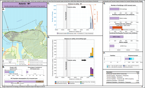 Example Astoria community profile page for the M1 scenario.
Reports by county from north to south:
-
Clatsop. Includes community-specific profiles for Astoria, Jeffers Garden, Warrenton, Gearhart, Seaside, Cannon Beach, and Arch Cape
-
Tillamook. Includes community-specific profiles for Manzanita, Nehalem Bay State Park, Nehalem, Wheeler, Rockaway Beach, Barview, Garibaldi, Bay City, Tillamook, Cape Meares, Oceanside, Netarts, Cape Lookout Sate Park, Sand Lake Recreation Area, Tierra Del Mar, Pacific City, and Neskowin
-
Lincoln. Coming soon as O-20-02. Includes comunity-specific profiles for Lincoln City, Gleneden Beach, Lincoln Beach, Depoe Bay, Otter Rock, Beverly Beach State Park, Noewport, South Beach State Park, Toledo, Seal Rock, Bayshore, Waldport, Beachside State recreation Site, Tillicum Beach Campground, and Yachats
-
Lane. Expected release mid 2021.
-
Douglas. Expected release late 2021.
-
Coos. Expected release early 2022.
-
Curry. Expected release mid 2022.
Cross-county pilot study. For Gearhart, Rockaway Beach, Lincoln City, Newport, and Port Orford
Natural Hazard Risk Assessments
These county-wide risk assessments provide Oregon communities with a detailed understanding of their risk from many natural hazards, including tsunamis, to give communities the ability to compare their risk across multiple hazards and to prioritize and take actions that will reduce risk. The results can also inform the natural hazard mitigation planning process.
Available reports by coastal county from north to south; reports for other counties expected in mid to late 2021:
-
Clatsop County. Includes Astoria, Cannon Beach, Gearhart, Seaside, and Warrenton and the unincorporated communities of Arch Cape, Svensen-Knappa, and Westport
-
Lincoln County. Includes Lincoln City, Depoe Bay, Siletz, Newport, Toledo, Waldport, and Yachats, Confederated Tribes of Siletz Indians land, and the unincorporated communities of Otis-Rose Lodge, Salishan-Lincoln Beach, Otter Rock, Seal Rock-Bayshore, and Wakonda Beach
-
Curry County. Includes Brookings, Gold Beach, and Port Orford and unincorporated communities of Harbor and Nesika Beach