Siletz Bay Project (First DOGAMI Tsunami Inundation Map)
In 1995, DOGAMI, in collaboration with the Oregon Graduate Institute of Science & Technology and Portland State University, completed a tsunami hazard map for Siletz Bay (DOGAMI Open-File Report O-95-5). Siletz Bay was picked because it has prehistoric tsunami deposits whose thickness and distribution give clues about the elevation of prehistoric tsunamis from the Cascadia subduction zone. In the map below, Cascadia tsunami sands deposited ~300 and ~800 years ago are absent in cores behind higher parts of Salishan Spit, suggesting that these two tsunamis were lower than these parts of the spit. When uncertainties in tides and height of the sand spit 600-800 years ago are taken into account, these two Cascadia tsunamis were probably 23-30 ft high at Salishan Spit with a maximum range of 16 and 39 feet high.
These estimated heights were used to establish the order of magnitude of likely run-up from Cascadia subduction zone tsunamis. A computer-generated Cascadia subduction zone earthquake source was then constructed to approximately match these run-up heights at Salishan Spit. The resulting tsunami hazard map illustrated inundation from this most likely event and the uncertainty of inundation using a worst case and minimum Cascadia event. This same general approach was followed for inundation maps completed between 1996 and 2007 but with more sophisticated earthquake sources and tsunami simulation software (see
Florence project). DOGAMI has recently updated the tsunami inundation mapping technology (see
Cannon Beach project) and is in the
process of remapping the entire coast by 2013
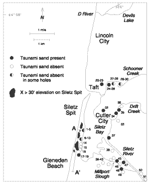
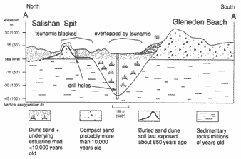
Map and cross section above illustrate the data used to infer the run-up heights of ancient Cascadia subduction zone tsunamis ~300-800 years ago. Note that the cross section also shows the ancient Siletz River channel filled over the last 10,000 years with sediment as sea level rose to its present height. The channel fill was penetrated by the deepest drill hole. Drill holes provided geotechnical data for a complementary study (DOGAMI GMS-93) of earthquake hazards. Illustrations are from DOGAMI Open-file Report O-95-5.
 Siletz Bay tsunami inundation map (DOGAMI GMS-99) illustrates the minimum, most likely, and worst case inundation from Cascadia tsunamis. Corresponding run-up heights at the open coast are ~20-25 ft, 30-35 ft, and 50-55 ft.