Background
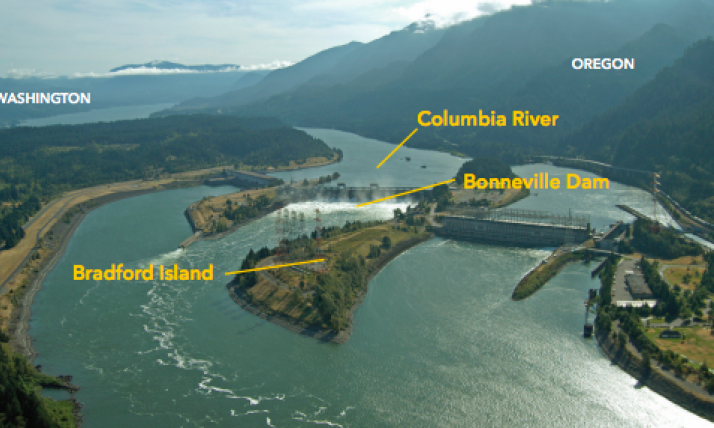
Bradford Island is situated on the Columbia River about three miles west of Cascade Locks, Oregon and 40 miles east of Portland, Oregon. Bradford Island is part of the Bonneville Dam Complex, owned and operated by the United States Army Corps of Engineers (USACE). Beginning with the Bonneville Dam's construction in 1928, USACE used Bradford Island for many activities, including chemical storage, equipment storage and waste disposal. Until 1982, USACE disposed of hazardous waste in a landfill on the eastern side of Bradford Island. There was also an outdoor pistol range and several light bulb/electrical equipment disposal sites, both on the island itself and in the river.
Photo Credit: Bonneville Power Administration
These activities resulted in chemical pollution (i.e., contamination) across Bradford Island's soil, groundwater, and in the sediment off its shore. Beginning in 1997, USACE has conducted studies to determine the extent of the pollution and explore cleanup options. The primary contaminants that have been identified in soil and/or groundwater include selected metals; polychlorinated biphenyls (PCBs); semivolatile organic compounds (SVOCs), including polycyclic aromatic hydrocarbons (PAHs); butylins; volatile organic compounds (VOCs); and a few pesticides/herbicides. The contaminants of interest identified in the offshore sediments and/or resident fish tissue samples include selected metals, PCBs, pesticides, and PAHs. These chemicals are harmful to human and ecological health. PCBs, which are highly toxic, do not easily break down and can accumulate in the bodies of resident fish. PCBs have been found in resident fish at levels that are considered unsafe to eat. Both the Oregon Health Authority and the Washington State Department of Health have "Do Not Eat"
fish consumption advisories for resident fish in the area. Although electrical equipment was removed from the river in 2002 and some contaminated sediment was removed in 2007, contamination is still a problem. If you would like to learn more about the cleanup process, view the
EPA's Bradford Island Superfund Site webpage:
Click HERE.
In March 2022, the U.S. Environmental Protection Agency added Bradford Island to the National Priorities List (NPL), making it a Superfund site. The NPL is a list of sites throughout the U.S. that EPA prioritizes for cleanup due to known releases or threatened releases of hazardous substances, pollutants, or contaminants.
Bradford Island Public Health Assessment
The listing of Bradford Island as a Superfund site initiated a requirement for EHAP to create a Public Health Assessment of the site on behalf of ATSDR. A Public Health Assessment (PHA) evaluates the human health risks associated with use(s) of the site. EHAP is working closely with agency and Tribal partners to understand the ways Bradford Island has been and is used. EHAP will use this information to evaluate the health risks associated with the uses of the site.
If you would like to receive email updates on the Bradford Island PHA, please email ehap.info@odhsoha.oregon.gov or call (971)-673-0482 and we'll add your name to our Bradford Island listserv.
Community Concerns
The area that encompasses the Bradford Island site stretches from the Bonneville Dam upstream one mile, to the mouth of Ruckel Creek (the border of Multnomah and Hood River counties). This entire area is designated for Tribal fishing. There are many fishing platforms along both sides of the river, used during salmon and steelhead harvests.
The Columbia River Inter-Tribal Fish Commission (CRITFC) operates and maintains 31 fishing sites along Zone 6 of the Columbia River. These areas are for the exclusive use of Tribal fishers from the four CRITFC member Tribes, which includes the Confederated Bands and Tribes of the Yakama Nation, Confederated Tribes of the Umatilla Indian Reservation (CTUIR), Confederated Tribes of the Warm Springs Reservation of Oregon, and the Nez Perce Tribe. (Three sites do have shared-use facilities with the public.) These sites were set aside by Congress to provide fishing locations to Tribal fishers who traditional fishing grounds were inundates behind dams. See more at the
CRITFC website:
 Click HERE
Public Communications and Engagement
Check back here for updates on engagement opportunities. Or, email ehap.info@odhsoha.oregon.gov or call (971)-673-0492 and we'll add your name to our Bradford Island listserv.
Health Education Resources
Fish Advisory Poster
This one-page poster shows where fish are unsafe to eat, which fish should be limited, and which are healthy.
Fish Advisory Flyers
This one-page flyer shows where fish are unsafe to eat, which fish should be limited, and which fish are healthy choices. This flyer also explains why there is a fish consumption advisory, health risks and when the advisory is in effect.
Fish Advisory Fact Sheets
This two-page fact sheet provides information on where the fish consumption advisory applies, which fish should be avoided or limited, and health risks. It also discusses why there is a fish consumption advisory and healthier fish preparation methods.
Safe Fish Choices for Pregnancy and Children Brochure
People who are or may become pregnant, breastfeeding, and children under age six are more at-risk for harmful health effects from eating polluted fish. Use this brochure to learn which fish are safe to eat from the Lower and Middle Columbia River and near the Bonneville Dam.