
Oregon State Flag An official website of the State of Oregon »

Drone Map Classification Criteria Feedback


January 30, 2024 12 PM Update:

We asked and received your thoughts, feedback, and ideas from Oct. 23 through Dec. 29, 2023. The feedback period is now closed. Thank you for your feedback. 

Staff worked to gather the feedback received and take back to the workgroup. All comments are located here as an excel file: 2023 Drone_Feedback _results-website.xlsx sheet and all attached letters are compiled in this file

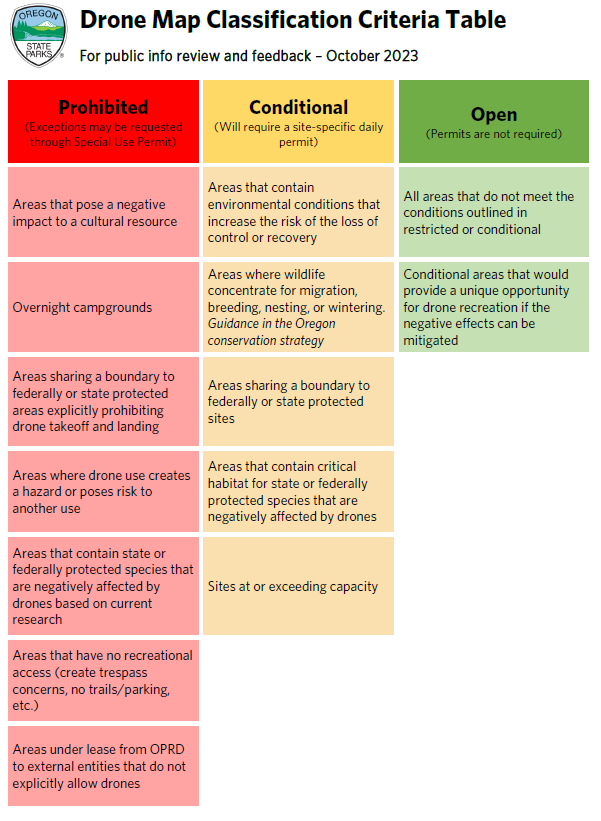
A workgroup of conservation groups, drone users, state, and federal natural resource agencies, and OPRD staff worked to create criteria where each park maps can easily identify where drones are allowed take-off and land (the table to the right will open as a pdf by clicking on it). The maps will also show areas where drones cannot take-off and land.

We shared three sample areas with maps developed following the classification criteria developed by the workgroup and staff.

Watch the virtual open house that was held on Nov. 8. 
Questions asked during the Q&A time (40:20): Drone open house Question Report.pdf


Helpful Resources

dronetimeline202312.PNG