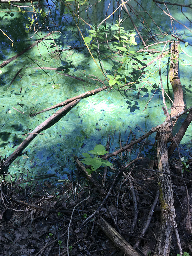
Oregon State Flag An official website of the State of Oregon »

Oregon Health Authority logo

Current Cyanobacteria Advisories

Current cyanobacteria harmful algal bloom (CyanoHAB) recreational use health advisories are listed in the table below and displayed on the Oregon Harmful Algal Bloom Advisories map. Both the table and map are updated regularly with the latest information as advisories are issued and lifted throughout the season for monitored water bodies. 

Help us improve CyanoHAB advisory notifications! We're collecting feedback to improve how we share information about beach water quality. Please take a few minutes to complete our short survey here: https://forms.office.com/g/ErFtL3cL1j

Remember: Only a fraction of all water bodies in Oregon are visually monitored or sampled due to limited physical and monetary resources. A water body with no recreational health advisory is not an indication that a bloom is not present. You are your own best advocate when ensuring your safety, and that of your family and pets. Be aware and "when in doubt, stay out."

Click the buttons below to access the interactive Oregon Harmful Algal Bloom Advisories map: 

Advisory Map (English)  Mapa de Advertencia (Español)  Advisory Map (Mobile)  Mapa de Advertencia (Móvil)  

Report a suspected cyanobacteria harmful algal bloom (CyanoHAB) or related illness: 

HAB Reporting Form  Animal Illness Reporting Form  Human Illness Reporting Form 

Advisory Levels

permanent= Advisory in effect  advisory= Precaution in effect lifted= Advisory/precaution has been lifted

  • Advisory: Cyanotoxins have been confirmed through testing and are at unsafe levels, or a bloom has been sighted and water will be sampled within 1 business day. 
  • Precaution: A bloom has been sighted and water sampling is unavailable within 1 business day due to limited resources. 
  • Advisory/Precaution Lifted: An 'Advisory' is lifted when water testing shows safe levels. If a site has previously tested at unsafe levels, regular testing continues until the bloom is visibly gone and cyanotoxins are at safe levels. A 'Precaution' is lifted when testing shows cyanotoxin levels are safe, or when the bloom is visibly gone. 


Waterbody 
Status
Date/Link 
County 
Toxin  Data   


North and South Tenmile Lakes
advisoryPrecaution Lifted
12/3/2025
Coos
Oswego Lake
Red.svgAdvisory Lifted
10/15/2025
Clackamas
Prineville Reservoir
Red.svgAdvisory
9/19/2025
Crook
Microcystin
231 ug/L
Haystack Reservoir
advisoryPrecaution Lifted
9/15/2025
Jefferson
Lake Simtustus
Red.svgAdvisory Lifted
8/29/2025
Jefferson

Ochoco Lake
Red.svgAdvisory Lifted
9/30/2025
Crook


Ross Island Lagoon, Willamette River
liftedPrecaution Lifted
9/16/2025
Multnomah
Powder Arm, Brownlee Reservoir
Red.svgAdvisory Lifted
11/7/2025
Baker


Hells Canyon Reservoir
Red.svgAdvisory Lifted
11/18/2025
Baker & Wallowa


Odell Lake
Red.svgAdvisory Lifted
8/26/2025
Klamath


Willamette River, Ross Island Bridge to Wapato Bridge and Kelley Point Park
Red.svgAdvisory Lifted
8/19/2025
Multnomah
Cullaby Lake
Red.svgPrecaution Lifted
9/5/2025
Clatsop
Devils Lake
advisoryPrecaution Lifted
10/21/2025
Lincoln
Loon Lake
Red.svgPrecaution Lifted
8/12/2025
Douglas
Brownlee Reservoir
Red.svgAdvisory
8/1/2025
Baker
Microcystin
>50 ug/L
Gerber Reservoir
advisoryPrecaution
8/1/2025
Klamath

Smith Reservoir
advisoryPrecaution Lifted
10/7/2025
Klamath
Eckman Lake
Red.svgAdvisory Lifted
10/21/2025
Lincoln


Upper Klamath Lake 
Red.svgAdvisory
7/24/2025
Klamath
Microcystin
8.19 ug/L
Bully Creek Reservoir
Red.svgAdvisory Lifted
11/7/2025
Malheur


Thief Valley Reservoir
Red.svgAdvisory
8/20/2025
Baker & Union
Microcystin
37.7 ug/L
Upper Klamath National Wildlife Refuge
Red.svgAdvisory Lifted
12/3/2025
Klamath


Antelope Flat Reservoir
advisoryPrecaution Lifted
8/19/2025
Crook
Unity Reservoir
Red.svgAdvisory Lifted
11/7/2025
Baker


Lake Billy Chinook
Red.svgAdvisory Lifted
7/1/2025
Jefferson


Fern Ridge Reservoir
Red.svgAdvisory Lifted
6/24/2025
Lane
Lost Creek Lake
Red.svgAdvisory Lifted
7/1/2025
Jackson


Crane Prairie Reservoir
advisoryPrecaution Lifted
6/13/2025
Deschutes
Lake Owyhee (northern portion, starting at Indian Creek Campground extending to the reservoir outflow
Red.svgPrecaution Lifted
7/30/2025
Malheur

Emigrant Lake
Red.svgAdvisory Lifted
5/9/2025
Jackson

Wapato Marsh at Oaks Bottom Wildlife Refuge
Red.svgAdvisory Lifted
12/2/2025
Multnomah


South Umpqua River and mainstream Umpqua River permanentPermanent Advisory
Posted SignDouglas


Note: This table only includes health advisories for HABs affecting water bodies in the state of Oregon. To find advisories for water bodies in bordering states, please refer to the following websites:


Douglas County Permanent Recreational Use Advisory: South Umpqua River and mainstem Umpqua River

The advisory covers the South Umpqua River from Canyonville downstream to the confluence with the mainstem Umpqua River, and the mainstem Umpqua River downstream past Elkton to Sawyers Rapids. Pools in the bedrock along the rivers edge are known to develop cyanobacteria (blue-green algae) blooms that can be harmful to pets and people if accidental ingestion occurs. Signs have been posted at several access areas along the river.