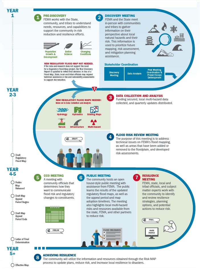
The multi-year
Risk MAP process can provide a suite of services that can include mapping, analysis, public outreach, trainings, technical assistance, and grant assistance to support a community's priorities toward addressing vulnerabilities to flooding and other types of natural hazards.
FEMA, communities, and residents collaborate throughout and after the flood mapping process of the Risk MAP assessment. First, the Risk MAP project team learns as much as it can about local flood risk challenges and goals in the
Discovery process. Public input can help identify potential impacts to natural and cultural resources, low-income and minority communities, and tribes. This can also help shape project scopes to provide better mitigation outcomes.
Next, the
Risk Analysis and Mapping phase begins and the Risk MAP project team determines what communities will be included in the study area and meets with local officials to talk about next steps and share resources to support the process. The team also begins engineering analysis that leads to the initial, draft updates to the flood maps, called
work maps.
Creating the work maps is a technical effort that can take months or years. Precise and accurate topographic information is key to producing good, accurate flood maps. Mapping updates use
LiDAR, short for 'light detection and ranging.' This is a remote surveying technology that sends laser pulses to map the landscape from a small airplane as it flies over the terrain. Risk MAP LiDAR surveys are performed by a range of institutions and organizations. The Oregon LiDAR Consortium (OLC) is led by the
Oregon Department of Geology and Mineral Industries (DOGAMI) to coordinate LiDAR efforts, data quality control, and data distribution through
the OLC website.
LiDAR maps are analyzed to identify ground hazards, geologic features, active faults, and levees. Surveys may also include detailed
hydrologic (how much water) and
hydraulic (where the water goes) analyses. Some areas, especially those near populated areas, will be mapped and reviewed by teams on the ground as well. The Risk MAP project team works with technical experts in each community to make sure the work maps line up with community knowledge and pinpoint areas with a 1% annual chance of flooding and how high floodwaters may rise along a waterway.
Download
Multi-year Risk MAP process in detail
Once a flood risk project begins, FEMA and its mapping partners move forward with analysis and data development. This phase depends on when funding was procured, timing of survey collection, and alignment with other third-party data. Quarterly Reports will keep communities up to date on the progress. When draft flood hazard areas are established, FEMA and their contractors schedule a
Flood Risk Review (FRR) meeting. Community officials can review draft flood hazard areas, water surface elevations, significant changes from the previous products, and mitigation opportunities for newly identified hazards. Communities are given a review period to identify areas of concern that may need additional refinements to flood mapping analysis. Following the FRR, FEMA and their contractors will consider map revisions based on the provided data.
The
Consultation Coordination Officer (CCO) Meeting occurs after the preliminary Flood Insurance Study (FIS) report and Flood Insurance Rate Map (FIRM) have been distributed. The CCO Meeting provides an avenue to review preliminary products, build upon discussions from prior phases, and facilitates planning for future due process and adoption stages.
If communities identify a need for outreach at the CCO Meeting, FEMA and state partners can hold a
Public Open House. The Open House allows for direct conversations about changing flood risk with the public, prompts property owners to talk about their risk, and provides time for community members to meet with subject matter experts.
A final touchpoint in the Risk MAP process is a
Resilience Workshop. This meeting brings together local agencies to network and learn about available mitigation and resilience resources. The goal is to strengthen the community's resilience by identifying risks, protecting against potential impacts, and providing a means to recover effectively after a disaster. Resilience is unique to each community. FEMA works with communities to integrate Risk MAP outcomes, such as best available hazard data, into their existing planning mechanisms. This will help communities to prepare for and act on their risk.