
Oregon State Flag An official website of the State of Oregon »

Oregon.gov Homepage

Contact

Contacts


Directions and Maps

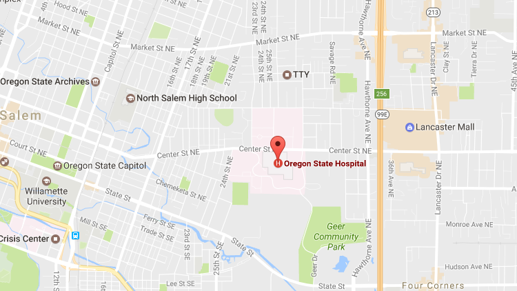
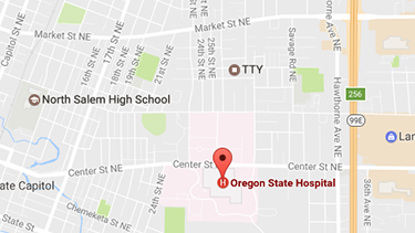
Oregon State Hospital – Salem
2600 Center Street NE
Salem, Oregon 97301
Phone: (503) 945-2800
Toll free: 1-800-544-7078
Map: Salem Campus (PDF)

Driving Directions to Salem campus

Northbound on I-5

  1. From I-5 Northbound, take the OR-213 S/Market Street NE exit, EXIT 256
  2. Use the left lane to keep left at the fork and follow signs for Fairgrounds/Amphitheatre
  3. At the light turn left onto Market St NE then immediately merge left into one of the left turn lanes
  4. At the first stoplight, turn left onto Hawthorne Avenue NE
  5. At the second stoplight, turn right onto Center Street NE
  6. Go approximately half a mile and turn left onto Recovery Drive

Southbound on I-5

  1. From I-5 Southbound, take the OR-213 S/Market Street NE exit, EXIT 256
  2. Keep right, follow the signs for City Center and merge onto Market Street NE
  3. Immediately merge left into one of the left turn lanes
  4. At the first stoplight, turn left onto Hawthorne Avenue NE
  5. At the second stoplight, turn right onto Center Street NE
  6. Go approximately half a mile and turn left onto Recovery Drive

Westbound on OR-22 E

  1. From OR-22 Eastbound, follow OR-22 E to Center Street NE in Salem
  2. Continue on Center Street NE through downtown and continue through the stoplight at 24th Street
  3. Turn right onto Recovery Drive

Parking

To park, take the right fork which leads down the hill. Feel free to park in any space marked either "visitor," "staff" or "C." There are plenty of handicapped parking spaces for those with placards. Depending on the time of day, parking can be limited, so please leave about five minutes to walk to the main entrance. You can also drop off passengers at the entrance via a circular driveway. When you arrive in the main lobby, you will sign in at the reception window and get a visitor badge.

Map Online

Salem Campus in Google Maps

google map screenshot of salem campus

 Scroll Up

Oregon State Hospital – Junction City
29398 Recovery Way
Junction City, Oregon 97448
Phone: (541) 465-2554
Toll free: 1-877-851-7330
Map: Junction City Campus (PDF)

Driving Directions to Junction City campus

Northbound on I-5

  1. From I-5 Northbound, take exit 195B onto the Randy Pape Beltline
  2. Take exit 6 towards Eugene Airport/Junction City
  3. Turn left on Highway 99 N toward Junction City
  4. Continue 6.6 miles turn right on Milliron Road
  5. Turn right onto Dreas Way
  6. Turn left on Recovery Way and into the parking lot of the hospital

Southbound on I-5

  1. From I-5 Southbound, take exit 209 Harrisburg/Junction City
  2. Turn right on Diamond Hill Road to Harrisburg
  3. Turn left onto OR-99 E to Junction City
  4. Continue through Junction City on Ivy Street/OR-99 S
  5. Continue on OR-99 S approximately 3.5 miles
  6. Turn left on Milliron Road
  7. Turn right on Dreas Way
  8. Turn left on Recovery Way and into the parking lot of the hospital

From the Oregon Coast

  1. Turn onto OR-126 E from Highway 101 in Florence
  2. Take OR-126 through Veneta to Green Hill Road
  3. Turn left onto Green Hill Road
  4. Turn right onto Clear Lake Road
  5. Turn left onto OR-99 N
  6. Turn right onto Milliron Road
  7. Turn right on Dreas Way
  8. Turn left onto Recovery Way and into the parking lot of the hospital

Parking

Feel free to park in any "visitor" or unmarked spaces. There are plenty of handicapped parking spaces for those with placards. Depending on the time of day, parking can be limited. You can also drop off passengers at the entrance via a circular driveway. When you arrive in the main lobby, you will sign in at the reception window and get a visitor badge.

Map Online

Junction City Campus in Google Maps

Junction City campus map google screenshot

 Scroll Up