
Oregon State Flag An official website of the State of Oregon »

Erosion and Sediment

An excavator works to repair and shore up a roadside that has eroded.
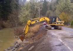
The goal of project erosion and sediment control is to prevent pollution of water resources as required by National Pollutant Discharge Elimination System permits and by other laws, permits, agencies and agreements.

Project Design Objectives include:

  • Establish specific measures to prevent soil erosion and off-site sedimentation.
  • Satisfy permit requirement for an Erosion and Sediment Control Plan.
  • Create clear contract documents to facilitate project construction.
  • Minimize project and permit problems for ODOT and project partners.

Guidance Materials

Additional support for specific geo-hydro and environmental needs in the form of:

  • ​Standard drawings and details,
  • Drafting manuals,
  • CAD standards,
  • ODOT workspace, and
  • Example drawings and templates.

Contact the Geo-Environmental Section's Drafting Program for information.

Federal

State

Climate Data

  • PRISM Climate Group - Gather climate observations from a wide range of monitoring networks to reveal short- and long-term climate patterns.

Soil Survey


​1200-CA Permit

  • This Final of the 1200-CA Permit is the document released for public review.  This permit provides an update to the last update in 2005 and the changes to the new permit are significant.  Among the new requirements are: a cover sheet for the Erosion and Sediment Control Plan (ESCP), natural buffer zone requirements between project work and water bodies, an Environmental Management Plan (EMP) to control pollutants and contaminated materials on project sites, an electronic portal for all communications with DEQ and a requirement that ESCP sheets be provided for each phase of work.
  • Appendix A is the guidance document on the development and use of the Environmental Management Plan (EMP) for contaminated media and pollutant control. 
 Appendix B
  • Appendix B is the guidance document regarding the new requirement that buffer zones of undisturbed vegetation be preserved between project work and water bodies.  Appendix B provides explanations of a variety of buffer zone conditions and it provides perimeter control direction if buffer zone conditions can not be met.
1200-CA-PER 
  • ​The PER is a Permit Evaluation Report.  This document is intended to provide guidance to permittees, and DEQ personnel, including inspectors, on the intent and interpretation of the permit.  The PER includes history, legal justification, guidance on interpretation and explanations of Permit language.  The intent of the PER is to standardize how the Permit will be interpreted and enforced across the state by all DEQ personnel.​
  • DEQ Response to Comments received​ by DEQ during the public comment period for the permit between 2/14/22-3/28/22​.

Contact the Geo-Environmental Section

4040 Fairview Industrial Drive SE, MS 6
Salem, Oregon 97302
Phone: 503-986-3252
Fax: 503-986-3249

Program Lead

Phone: 971-719-3796